نقشه پوشش اراضی ساحل عاج BNETD 2020 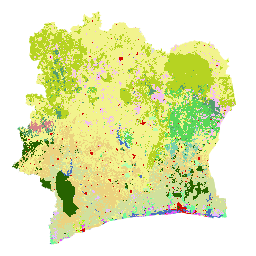
نقشه پوشش اراضی ساحل عاج BNETD 2020 توسط دولت ساحل عاج از طریق یک موسسه ملی، مرکز اطلاعات جغرافیایی و دیجیتال از دفتر مطالعات ملی، تکنیکها و توسعه (BNETD-CIGN)، با حمایت فنی و مالی اتحادیه اروپا تهیه شده است. روش ... طبقهبندی جنگلزدایی پوشش زمین جنگلی کاربری -پوشش زمین طبقهبندی جهانی جنگلها در سال ۲۰۲۰ برای تخمینهای زیستتوده روی زمینی IPCC، نسخه ۱ 
این مجموعه دادهها، کلاسهایی از جنگلهای جهانی را بر اساس وضعیت/وضعیت در سال ۲۰۲۰ با وضوح تقریباً ۳۰ متر ارائه میدهد. این دادهها از تولید تخمینهای سطح ۱ برای تراکم زیست توده چوبی خشک بالای زمین (AGBD) در جنگلهای طبیعی در اصلاحیه سال ۲۰۱۹ دستورالعملهای IPCC سال ۲۰۰۶ برای گلخانههای ملی پشتیبانی میکنند… زیست توده روی زمین ، طبقه بندی کربن، جنگل ، زیست توده جنگلی نقشه جهانی سه کلاسه PALSAR-2/PALSAR جنگلی/غیرجنگلی 
نسخه جدیدتری از این مجموعه داده با ۴ کلاس برای سالهای ۲۰۱۷-۲۰۲۰ را میتوانید در JAXA/ALOS/PALSAR/YEARLY/FNF4 پیدا کنید. نقشه جهانی جنگل/غیرجنگل (FNF) با طبقهبندی تصویر SAR (ضریب پراکندگی برگشتی) در موزاییک SAR PALSAR-2/PALSAR با وضوح جهانی ۲۵ متر تولید میشود، به طوری که پیکسلهای قوی و کم پراکندگی برگشتی ... آلوس، طبقهبندی آلوس۲، جنگل اروک ، زیستتوده جنگلی نقشه جهانی 4 کلاسه PALSAR-2/PALSAR جنگلی/غیرجنگلی 
نقشه جهانی جنگل/غیرجنگل (FNF) با طبقهبندی تصویر SAR (ضریب پراکندگی بازگشتی) در موزاییک SAR PALSAR-2/PALSAR با وضوح جهانی ۲۵ متر تولید میشود، به طوری که پیکسلهای با پراکندگی بازگشتی قوی و کم به ترتیب به عنوان "جنگل" و "غیرجنگل" تعیین میشوند. در اینجا، "جنگل" به عنوان جنگل طبیعی با ... تعریف میشود. آلوس، طبقهبندی آلوس۲، جنگل اروک ، زیستتوده جنگلی
Datasets tagged classification in Earth Engine
[null,null,[],[],[]]