Page Summary
-
OpenLandMap offers long-term MODIS LST day-time and night-time differences at 1 km based on the 2000-2017 time series, excluding Antarctica.
-
The VNP21A1D.002 product provides daily day land surface temperature and emissivity at 1km, compiled from daytime Level 2 Gridded products.
-
OpenLandMap Long-term Land Surface Temperature Monthly Day-Night Difference
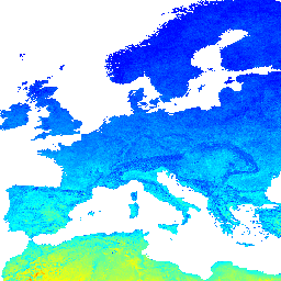
Long-term MODIS LST day-time and night-time differences at 1 km based on the 2000-2017 time series Derived using the data.table package and quantile function in R. For more info about the MODIS LST product see this page. Antarctica is not included. To access and visualize … climate day envirometrix lst mod11a2 modis -
VNP21A1D.002: Day Land Surface Temperature and Emissivity Daily 1km
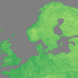
The NASA Suomi National Polar-Orbiting Partnership (Suomi NPP) Visible Infrared Imaging Radiometer Suite (VIIRS) Land Surface Temperature and Emissivity (LST&E) Day Version 1 product (VNP21A1D) is compiled daily from daytime Level 2 Gridded (L2G) intermediate products. The L2G process maps the daily VNP21 swath granules … climate daily day land nasa noaa