-
CFSR:气候预报系统再分析

美国国家环境预报中心 (NCEP) 气候预报系统再分析 (CFSR) 旨在提供 32 年记录期(从 1979 年 1 月到 2010 年 12 月)内这些耦合域状态的最佳估计值,并以全球高分辨率耦合大气-海洋-陆地表面-海冰系统执行。 气候 日光 通量 预报 地球物理 ncep -
CFSV2:NCEP 气候预测系统第 2 版,每 6 小时协调一次产品

美国国家环境预测中心 (NCEP) 气候预测系统 (CFS) 是一种完全耦合的模型,可表示地球大气、海洋、陆地和海冰之间的相互作用。CFS 是在 NCEP 的环境模型中心 (EMC) 开发的。将运行中的 CFS 升级到了 … 气候 日光 通量 预报 地球物理 ncep -
CPC 全球统一的基于地面观测站的每日降水分析

CPC 统一的基于地面观测的全球每日降水分析数据集提供 1979 年至今的陆地每日降水估计值。该数据集由 NOAA 的气候预测中心 (CPC) 开发,采用最佳插值技术,将全球雨量计网络的数据与 … 相结合 daily noaa precipitation weather -
CPC 全球统一温度

此数据集提供全球陆地表面每日气温的网格化分析,包括每日最高气温 (Tmax) 和最低气温 (Tmin)。涵盖 1979 年至今的数据,以 0.5 度经纬度网格呈现,与 CPC 基于地面观测的全球每日… climate daily noaa precipitation weather -
ETOPO1:全球 1 弧分高程

ETOPO1 是一个 1 分弧度的地球表面全球地形模型,集成了陆地地形和海洋测深数据。该模型基于众多全球和区域数据集构建而成。它包含两个海拔高度频段:ice_surface 和 bedrock。 基岩 DEM 海拔 海拔-地形 地球物理 冰 -
GFS:全球预报系统 384 小时预测大气数据

全球预报系统 (GFS) 是由美国国家环境预报中心 (NCEP) 生成的天气预报模型。GFS 数据集包含选定的模型输出(如下所述),以网格化预报变量的形式呈现。384 小时预报,其中 1 小时(最多 120 小时)和 3 小时(之后… 气候 云 通量 预报 地球物理 湿度 -
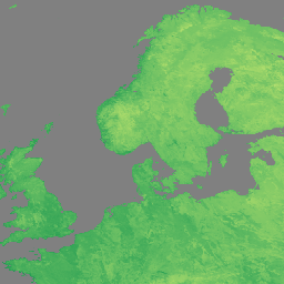
来自 AVHRR 传感器的 GIMMS NDVI(第 3 代)

GIMMS NDVI 是根据 NOAA 的多个 AVHRR 传感器生成的,适用于全球 1/12 度经纬度网格。GIMMS NDVI 数据集的最新版本名为 NDVI3g(来自 AVHRR 传感器的第三代 GIMMS NDVI)。 avhrr nasa ndvi noaa 植被 植被指数 -
GOES-16 FDCC 系列 ABI 2 级火点/热点特征 CONUS

Fire (HSC) 产品包含四张影像:一张是火点掩膜,另外三张的像素值分别表示火点温度、火点面积和火点辐射功率。ABI L2+ FHS 元数据掩模会为每个经过地球导航定位的像素分配一个标志,用于… abi fdc fire goes goes-16 goes-east -
GOES-16 FDCF 系列 ABI 2 级火点/热点特征全圆盘

Fire (HSC) 产品包含四张影像:一张是火点掩膜,另外三张的像素值分别表示火点温度、火点面积和火点辐射功率。ABI L2+ FHS 元数据掩模会为每个经过地球导航定位的像素分配一个标志,用于… abi fdc fire goes goes-16 goes-east -
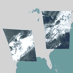
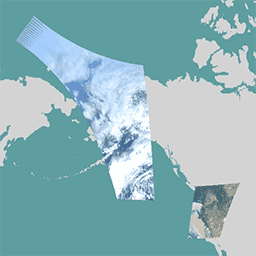
GOES-16 MCMIPC 系列 ABI 2 级云和湿气图像 CONUS
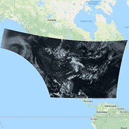
云和湿气图像产品的分辨率均为 2 公里。波段 1-6 为反射性波段。无量纲的“反射因子”量会根据太阳天顶角进行归一化。这些波段支持对云、植被、雪/冰和气溶胶进行表征。波段 7-16 为发射性波段。亮度温度… abi atmosphere goes goes-16 goes-east goes-r -
GOES-16 MCMIPF 系列 ABI 2 级云和湿气图像全圆盘

云和湿气图像产品的分辨率均为 2 公里。波段 1-6 为反射性波段。无量纲的“反射因子”量会根据太阳天顶角进行归一化。这些波段支持对云、植被、雪/冰和气溶胶进行表征。波段 7-16 为发射性波段。亮度温度… abi atmosphere goes goes-16 goes-east goes-r -
GOES-16 MCMIPM 系列 ABI 2 级云和湿气图像中尺度
云和湿气图像产品的分辨率均为 2 公里。波段 1-6 为反射性波段。无量纲的“反射因子”量会根据太阳天顶角进行归一化。这些波段支持对云、植被、雪/冰和气溶胶进行表征。波段 7-16 为发射性波段。亮度温度… abi atmosphere goes goes-16 goes-east goes-r -
GOES-17 FDCC 系列 ABI 2 级火点/热点特征 CONUS

Fire (HSC) 产品包含四张影像:一张是火点掩膜,另外三张的像素值分别表示火点温度、火点面积和火点辐射功率。ABI L2+ FHS 元数据掩模会为每个经过地球导航定位的像素分配一个标志,用于… abi fdc fire goes goes-17 goes-s -
GOES-17 FDCF 系列 ABI 2 级火点/热点特征全圆盘

Fire (HSC) 产品包含四张影像:一张是火点掩膜,另外三张的像素值分别表示火点温度、火点面积和火点辐射功率。ABI L2+ FHS 元数据掩模会为每个经过地球导航定位的像素分配一个标志,用于… abi fdc fire goes goes-17 goes-s -
GOES-17 MCMIPC 系列 ABI 2 级云和湿气图像(美国大陆)

云和湿气图像产品的分辨率均为 2 公里。波段 1-6 为反射性波段。无量纲的“反射因子”量会根据太阳天顶角进行归一化。这些波段支持对云、植被、雪/冰和气溶胶进行表征。波段 7-16 为发射性波段。亮度温度… abi atmosphere goes goes-17 goes-s mcmip -
GOES-17 MCMIPF 系列 ABI 2 级云和湿气图像全圆盘

云和湿气图像产品的分辨率均为 2 公里。波段 1-6 为反射性波段。无量纲的“反射因子”量会根据太阳天顶角进行归一化。这些波段支持对云、植被、雪/冰和气溶胶进行表征。波段 7-16 为发射性波段。亮度温度… abi atmosphere goes goes-17 goes-s mcmip -
GOES-17 MCMIPM 系列 ABI 2 级云和湿气图像中尺度
云和湿气图像产品的分辨率均为 2 公里。波段 1-6 为反射性波段。无量纲的“反射因子”量会根据太阳天顶角进行归一化。这些波段支持对云、植被、雪/冰和气溶胶进行表征。波段 7-16 为发射性波段。亮度温度… abi atmosphere goes goes-17 goes-s mcmip -
GOES-18 FDCC 系列 ABI 2 级火点/热点特征 CONUS

Fire (HSC) 产品包含四张影像:一张是火点掩膜,另外三张的像素值分别表示火点温度、火点面积和火点辐射功率。ABI L2+ FHS 元数据掩模会为每个经过地球导航定位的像素分配一个标志,用于… abi fdc fire goes goes-18 goes-t -
GOES-18 FDCF 系列 ABI 2 级火点/热点特征全圆盘

Fire (HSC) 产品包含四张影像:一张是火点掩膜,另外三张的像素值分别表示火点温度、火点面积和火点辐射功率。ABI L2+ FHS 元数据掩模会为每个经过地球导航定位的像素分配一个标志,用于… abi fdc fire goes goes-18 goes-t -
GOES-18 MCMIPC 系列 ABI 2 级云和湿气图像 CONUS

云和湿气图像产品的分辨率均为 2 公里。波段 1-6 为反射性波段。无量纲的“反射因子”量会根据太阳天顶角进行归一化。这些波段支持对云、植被、雪/冰和气溶胶进行表征。波段 7-16 为发射性波段。亮度温度… abi atmosphere goes goes-18 goes-t goes-west -
GOES-18 MCMIPF 系列 ABI 2 级云和湿气图像全圆盘

云和湿气图像产品的分辨率均为 2 公里。波段 1-6 为反射性波段。无量纲的“反射因子”量会根据太阳天顶角进行归一化。这些波段支持对云、植被、雪/冰和气溶胶进行表征。波段 7-16 为发射性波段。亮度温度… abi atmosphere goes goes-18 goes-t goes-west -
GOES-18 MCMIPM 系列 ABI 2 级云和湿气图像中尺度

云和湿气图像产品的分辨率均为 2 公里。波段 1-6 为反射性波段。无量纲的“反射因子”量会根据太阳天顶角进行归一化。这些波段支持对云、植被、雪/冰和气溶胶进行表征。波段 7-16 为发射性波段。亮度温度… abi atmosphere goes goes-18 goes-t goes-west -
GOES-19 FDCC 系列 ABI 2 级火点/热点特征 CONUS
GOES 卫星是由 NOAA 运行的地球同步气象卫星。Fire (HSC) 产品包含四张影像:一张是火点掩膜,另外三张的像素值分别表示火点温度、火点面积和火点辐射功率。ABI L2+ FHS 元数据… abi fdc fire goes goes-19 goes-east -
GOES-19 FDCF 系列 ABI 2 级火点/热点特征全圆盘

Fire (HSC) 产品包含四张影像:一张是火点掩膜,另外三张的像素值分别表示火点温度、火点面积和火点辐射功率。ABI L2+ FHS 元数据掩模会为每个经过地球导航定位的像素分配一个标志,用于… abi fdc fire goes goes-19 goes-east -
GOES-19 MCMIPC 系列 ABI 2 级云和湿气图像 CONUS

云和湿气图像产品的分辨率均为 2 公里。波段 1-6 为反射性波段。无量纲的“反射因子”量会根据太阳天顶角进行归一化。这些波段支持对云、植被、雪/冰和气溶胶进行表征。波段 7-16 为发射性波段。亮度温度… abi atmosphere goes goes-19 goes-east goes-u -
GOES-19 MCMIPF 系列 ABI 2 级云和湿气图像全圆盘

云和湿气图像产品的分辨率均为 2 公里。波段 1-6 为反射性波段。无量纲的“反射因子”量会根据太阳天顶角进行归一化。这些波段支持对云、植被、雪/冰和气溶胶进行表征。波段 7-16 为发射性波段。亮度温度… abi atmosphere goes goes-19 goes-east goes-u -
GOES-19 MCMIPM 系列 ABI 2 级云和湿气图像中尺度

云和湿气图像产品的分辨率均为 2 公里。波段 1-6 为反射性波段。无量纲的“反射因子”量会根据太阳天顶角进行归一化。这些波段支持对云、植被、雪/冰和气溶胶进行表征。波段 7-16 为发射性波段。亮度温度… abi atmosphere goes goes-19 goes-east goes-u -
International Best Track Archive for Climate Stewardship 项目

International Best Track Archive for Climate Stewardship (IBTrACS) 提供全球热带气旋的位置和强度。数据范围从 19 世纪 40 年代至今,通常以 3 小时为间隔提供数据。虽然最佳轨迹数据侧重于位置和强度(最大持续风速… climate hurricane noaa table weather -
NCEP-DOE Reanalysis 2(高斯网格),总云量

此合集已不再更新。来源中的模型不再更新。NCEP-DOE Reanalysis 2 项目使用前沿的分析/预测系统,利用 1979 年到前一年的历史数据执行数据同化。 atmosphere climate cloud geophysical ncep noaa -
NCEP/NCAR 再分析数据,海平面气压 [已弃用]

NCEP/NCAR 再分析项目是美国国家环境预报中心(NCEP,前身为“NMC”)和美国国家大气研究中心(NCAR)的联合项目。这项联合工作的目标是使用历史数据生成新的大气分析结果,并… atmosphere climate geophysical ncep noaa pressure -
NCEP/NCAR 再分析数据,地表温度 [已弃用]

NCEP/NCAR 再分析项目是美国国家环境预报中心(NCEP,前身为“NMC”)和美国国家大气研究中心(NCAR)的联合项目。这项联合工作的目标是使用历史数据生成新的大气分析结果,并… atmosphere climate geophysical ncep noaa reanalysis -
NCEP/NCAR 再分析数据,水汽 [已弃用]

NCEP/NCAR 再分析项目是美国国家环境预报中心(NCEP,前身为“NMC”)和美国国家大气研究中心(NCAR)的联合项目。这项联合工作的目标是使用历史数据生成新的大气分析结果,并… atmosphere climate geophysical ncep noaa reanalysis -
NOAA AVHRR Pathfinder 版本 5.3 整理的全球 4 公里海面温度

AVHRR Pathfinder 第 5.3 版海面温度数据集 (PFV53) 是由 NOAA 国家海洋数据中心和迈阿密大学的 Rosenstiel 海洋与大气科学学院合作制作的全球性海面温度数据,每天更新两次,分辨率为 4 公里。PFV53 … avhrr noaa oceans sst temperature wind -
NOAA CDR AVHRR AOT:全球海洋上空的每日气溶胶光学厚度,版本 04

气溶胶光学厚度 (AOT) 的 NOAA 气候数据记录 (CDR) 是一组全球每日 0.1 度派生数据,这些数据来自 PATMOS-x AVHRR 2b 级通道 1(0.63 微米)轨道晴空辐射。气溶胶产品是在无云条件下根据 AVHRR 影像生成的,时间为… aerosol atmosphere atmospheric avhrr cdr daily -
NOAA CDR AVHRR LAI FAPAR:叶面积指数和光合有效辐射吸收比,版本 5

AVHRR 叶面积指数 (LAI) 和光合有效辐射吸收比 (FAPAR) NOAA 气候数据记录 (CDR) 数据集包含表征植物冠层和光合作用活动的派生值。此数据集源自 NOAA AVHRR 地表反射率产品,… avhrr cdr daily fapar lai land -
NOAA CDR AVHRR NDVI:归一化差值植被指数,版本 5

AVHRR 常态化差值植生指标 (NDVI) 的 NOAA 气候数据记录 (CDR) 包含从 NOAA AVHRR 地表反射率产品中导出的网格化每日 NDVI。它提供了一种地表植被覆盖活动测量方法,以 0.05° 的分辨率进行网格化,并在全球陆地上进行计算… avhrr cdr daily land ndvi noaa -
NOAA CDR AVHRR:地表反射率,版本 5

NOAA AVHRR 地表反射率气候数据记录 (CDR) 包含网格化每日地表反射率和亮度温度,这些数据源自七颗 NOAA 极地轨道卫星上搭载的高级甚高分辨率辐射计 (AVHRR) 传感器。数据以 0.05° 的分辨率进行网格化,并计算… avhrr cdr daily land noaa reflectance -
NOAA CDR GRIDSAT-B1:地球静止红外通道亮度温度

注意:由于基础设施正在更新,自 2024-03-31 以来,提供方一直未更新此数据集。目前尚无数据集更新恢复的具体时间表。此数据集提供来自地球静止卫星的全球红外测量高质量气候数据记录 (CDR)。… 亮度 cdr 气候 红外 noaa 反射率 -
NOAA CDR OISST v02r01:最佳插值海平面温度

NOAA 1/4 度每日最佳插值海表温度 (OISST) 通过在常规全球网格上合并来自不同平台(卫星、船舶、浮标)的偏差调整观测结果来构建完整海洋温度场,并通过插值填充缺口。来自高级甚高分辨率…的卫星数据 avhrr cdr daily ice noaa oceans -
NOAA CDR PATMOSX:云属性、反射率和亮度温度,版本 5.3

此数据集提供多种云属性的高质量气候数据记录 (CDR),以及高级甚高分辨率辐射计 (AVHRR) Pathfinder Atmospheres Extended (PATMOS-x) 亮度温度和反射率。这些数据已拟合到 0.1 x 0.1 的等角度网格,其中包含升序和… atmospheric avhrr brightness cdr climate cloud -
NOAA CDR VIIRS LAI FAPAR:叶面积指数和光合有效辐射吸收比,版本 1

此气候数据记录 (CDR) 结合了叶面积指数 (LAI) 和光合有效辐射吸收比 (FAPAR) 数据集,这两个生物物理变量可用于评估植被压力、预测农业产量并支持其他建模和资源管理工作。LAI 跟踪单位地表面积的单侧… cdr daily fapar lai land noaa -
NOAA CDR VIIRS NDVI:归一化差值植被指数,版本 1

此数据集包含网格化每日归一化差值植被指数 (NDVI),该指数源自 NOAA 可见光红外成像辐射计套件 (VIIRS) 地表反射率的气候数据记录 (CDR)。数据记录涵盖了 2014 年至今,使用的是 NOAA 极地轨道卫星的数据。这些数据是预测的… cdr daily land ndvi noaa vegetation-indices -
NOAA CDR WHOI:海面温度,版本 2

“海面温度 - WHOI”数据集是 NOAA 海洋表面数据包 (OSB) 的一部分,可提供无冰海洋的高质量海面温度气候数据记录 (CDR)。SST 值是通过对昼夜变化进行建模并结合…来确定的 atmospheric cdr hourly noaa oceans oisst -
NOAA CDR:海洋热通量,版本 2

海洋热通量数据集是 NOAA 海洋表面捆绑包 (OSB) 的一部分,提供无冰海洋上空空气/海洋热通量的高质量气候数据记录 (CDR)。此数据集是根据近地表大气和海洋的 OSB CDR 形参计算得出的,… atmospheric cdr flux heat hourly noaa -
NOAA CDR:海洋近地表大气属性,版本 2

“海洋近地表大气属性”数据集是 NOAA 海洋表面捆绑包 (OSB) 的一部分,可提供高质量的气候数据记录 (CDR),其中包含无冰海洋表面的气温、风速和比湿。这些大气属性是根据亮度温度计算得出的… atmospheric cdr hourly humidity noaa oceans -
NOAA NHC HURDAT2 大西洋飓风目录

飓风最佳轨迹数据库 (HURDAT2)。大西洋盆地,1851 年至 2018 年。 climate hurricane nhc noaa table weather -
NOAA NHC HURDAT2 太平洋飓风目录

飓风最佳轨迹数据库 (HURDAT2)。太平洋盆地,1949-2018 年。 climate hurricane nhc noaa table weather -
PERSIANN-CDR:使用人工神经网络的遥感信息降水估计 - 气候数据记录

PERSIANN-CDR 是一种每日准全球降水产品,涵盖 1983 年 1 月 1 日至今的时期。这些数据每季度生成一次,通常会有三个月的延迟。该产品由加利福尼亚大学尔湾分校的水文气象学和遥感中心开发… cdr climate geophysical noaa precipitation weather -
RTMA:实时中尺度分析

实时中尺度分析 (RTMA) 是一种针对近地表天气条件的高空间和时间分辨率分析。此数据集包含美国本土的 2.5 公里级每小时分析。 atmosphere climate cloud geophysical humidity noaa -
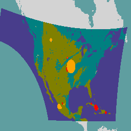
美国干旱监测

美国干旱监测图每周四发布,显示美国境内出现干旱的地区。该地图使用五种分类:异常干旱 (D0),表示可能正进入或正摆脱干旱的区域;以及四种干旱程度:… community-dataset drought noaa precipitation sat-io usda -
VIIRS 气溶胶光学深度和气溶胶粒子大小 EDR V3

VIIRS 气溶胶光学深度 (AOD) 和气溶胶粒子大小 (APS) 环境数据记录 (EDR) 产品提供从可见光红外成像辐射计套件 (VIIRS) 传感器检索到的气溶胶属性。主要产品是 550 nm 的 AOD,其他传感器通道也有额外的检索结果… aerosol aod atmosphere noaa viirs -
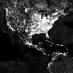
VIIRS 夜间昼夜年度波段合成 V2.1

年度全球 VIIRS 夜间灯光数据集是一个时间序列,由 2013 年至 2021 年的月度无云平均辐射网格生成。2022 年的数据可在 NOAA/VIIRS/DNB/ANNUAL_V22 数据集中找到。初始过滤步骤移除了阳光照射、月光照射和多云的像素,从而生成了粗略的合成图像,… annual dnb eog lights nighttime noaa -
VIIRS 夜间日间/夜间年度波段合成影像 V2.2

年度全球 VIIRS 夜间灯光数据集是一个时间序列,由 2022 年的月度无云平均辐射网格生成。如需查看更早年份的数据,请参阅 NOAA/VIIRS/DNB/ANNUAL_V21 数据集。初始过滤步骤移除了阳光照射、月光照射和多云的像素,从而生成包含以下内容的粗略合成图像… annual dnb eog lights nighttime noaa -
VIIRS 夜间昼夜波段合成影像版本 1

使用可见光红外成像辐射计套件 (VIIRS) 昼夜频段 (DNB) 的夜间数据生成的月平均辐射合成图像。由于这些数据是按月合成的,因此在全球许多地区,我们无法获得当月优质的数据覆盖。… dnb eog lights monthly nighttime noaa -
VIIRS 杂散光校正夜间昼夜波段合成影像版本 1

使用可见光红外成像辐射计套件 (VIIRS) 昼夜频段 (DNB) 的夜间数据生成的月平均辐射合成图像。由于这些数据是按月合成的,因此在全球许多地区,我们无法获得当月优质的数据覆盖。… dnb eog lights monthly nighttime noaa -
VNP09GA:VIIRS 地表反射率每日 500 米和 1 公里

可见光红外成像辐射计套件 (VIIRS) 每日地表反射率 (VNP09GA) 产品可提供 Suomi 国家极地轨道合作伙伴卫星计划 (S-NPP) VIIRS 传感器估算的地表反射率。提供的数据包含三个影像波段(I1、I2、I3),名义分辨率为 500 米(约 463 米)… daily nasa noaa npp reflectance satellite-imagery -
VNP09H1:VIIRS 地表反射率 8 天 L3 全球 500 米

8 天可见光红外成像辐射仪套件 (VIIRS) 地表反射率 (VNP09H1) 第 1 版合成产品可提供 Suomi 国家极轨伙伴卫星 (Suomi NPP) VIIRS 传感器在标称分辨率 500 米(约 463 米)的三个影像波段(I1、I2、I3)的地表反射率估计值。… daily nasa noaa npp reflectance satellite-imagery -
VNP13A1.002:VIIRS 植被指数 16 天 500 米

Suomi 国家极地轨道合作伙伴卫星计划 (S-NPP) NASA 可见光红外成像辐射计套件 (VIIRS) 植被指数 (VNP13A1) 数据产品通过在 16 天的采集期内以 500 米的分辨率选择最佳可用像素来提供植被指数。VNP13 数据产品旨在… 16 天 evi nasa ndvi noaa npp -
VNP14A1.002:热异常/火灾每日 L3 全球 1 公里 SIN 网格

Suomi 国家极地轨道合作伙伴卫星计划 NASA 可见光红外成像辐射计套件 (VIIRS) 热异常/火灾 (VNP14A1) 第 1 版数据产品提供有关活跃火灾和其他热异常的每日信息。VNP14A1 数据产品是一种全球性 1 公里网格化合成数据,包含从 … 检测到的火灾像素 fire land nasa noaa surface viirs -
VNP15A2H:LAI/FPAR 8 天 L4 全球 500 米 SIN 网格

可见光红外成像辐射计套件 (VIIRS) 叶面积指数 (LAI) 和光合有效辐射吸收比 (FPAR) 版本 1 数据产品以 500 米分辨率 (VNP15A2H) 提供有关植被冠层的信息。VIIRS 传感器位于 NOAA/NASA 联合 Suomi 国家… land nasa noaa surface vegetation-indices viirs -
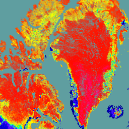
VNP21A1D.002:1 公里逐日白天陆地表面温度与发射率
NASA Suomi 国家极地轨道合作伙伴卫星计划 (Suomi NPP) 可见光红外成像辐射计套件 (VIIRS) 地表温度与发射率 (LST&E) 昼间第 1 版产品 (VNP21A1D),系由昼间 2 级格网 (L2G) 中间产品每日汇编而成。L2G 流程可将每日 VNP21 轨道分片数据映射到… climate daily day land nasa noaa -
VNP21A1N.002:1 公里逐日夜间地表温度与发射率

NASA Suomi 国家极地轨道合作伙伴卫星计划 (Suomi NPP) 可见光红外成像辐射计套件 (VIIRS) 地表温度与发射率 (LST&E) 夜间第 1 版产品 (VNP21A1N),系由夜间 2 级格网 (L2G) 中间产品每日汇编而成。L2G 流程可将每日 VNP21 轨道分片数据映射到… climate daily land nasa night noaa -
VNP22Q2.002:地表物候年度 L3 全球 500 米 SIN 网格

Suomi 国家极地轨道合作伙伴卫星计划 (Suomi NPP) NASA 可见光红外成像辐射计套件 (VIIRS) 地表物候年度 (VNP22Q2) 第 2 版数据产品以年度间隔提供全球地表物候 (GLSP) 指标。VNP22Q2 数据产品源自双波段的时间序列… land nasa ndvi noaa npp onset-greenness -
VNP43IA1:BRDF/反照率模型参数每日 L3 全球 500 米 SIN 网格

Suomi 国家极地轨道合作伙伴卫星计划 (Suomi NPP) NASA 可见光红外成像辐射计套件 (VIIRS) 双向反射率分布函数 (BRDF) 和反照率模型形参 (VNP43IA1) 第 1 版产品以 500 米分辨率提供核权重(形参)。VNP43IA1 产品每天使用 16 天的 VIIRS 数据生成… land nasa noaa satellite-imagery surface viirs -
VNP43IA2:BRDF/反照率质量每日 L3 全球 500 米 SIN 网格

Suomi 国家极地轨道合作伙伴卫星计划 (Suomi NPP) NASA 可见光红外成像辐射计套件 (VIIRS) 双向反射率分布函数 (BRDF) 和反照率质量 (VNP43IA2) 第 1 版产品以 500 米分辨率提供 BRDF 和反照率质量。VNP43IA2 产品每天使用 16 天的 VIIRS 数据生成… land nasa noaa satellite-imagery surface viirs -
VNP43IA4:BRDF/反照率质量每日 L3 全球 500 米 SIN 网格
NASA/NOAA Suomi 国家极地轨道合作伙伴卫星计划 (Suomi NPP) 可见光红外成像辐射计套件 (VIIRS) 天底双向反射率分布函数 (BRDF) 调整后的反射率 (NBAR) 第 2 版产品以 500 米分辨率提供 NBAR 估计值。VNP43IA4 产品每天使用 16 天的 VIIRS 数据生成… brdf land nasa noaa satellite-imagery surface -
VNP46A1:VIIRS 每日网格化昼夜波段 500 米线性纬度经度网格夜间

Suomi 国家极地轨道合作伙伴卫星计划 (SNPP) 可见光红外成像辐射计套件 (VIIRS) 支持一种昼夜频段 (DNB) 传感器,可提供全球每日夜间可见光和近红外 (NIR) 光测量数据,适用于地球系统科学和应用。VIIRS DNB 在低光条件下的超高灵敏度… daily dnb nasa noaa population viirs -
VNP46A2:VIIRS 采用月球间隙填充技术的 BRDF 夜间灯光每日 L3 全球 500 米数据
Suomi 国家极地轨道合作伙伴卫星计划 (SNPP) 可见光红外成像辐射计套件 (VIIRS) 支持一种昼夜频段 (DNB) 传感器,可提供全球每日夜间可见光和近红外(NIR) 光测量数据,适用于地球系统科学和应用。VIIRS DNB 在弱光条件下的超高灵敏度… brdf daily nasa nighttime noaa population
Datasets tagged noaa in Earth Engine
[null,null,[],[],["This compilation presents diverse environmental datasets from sources like NASA, NOAA, and NCEP. Key data include: GIMMS NDVI vegetation index, VIIRS surface reflectance, thermal anomalies, LAI/FPAR, and land surface temperatures. Also included are atmospheric properties like sea-level pressure, surface temperature, and water vapor. NOAA's datasets offer sea surface temperatures, aerosol optical thickness, vegetation indices, ocean properties, and hurricane tracking. Climate forecasts, fire data, elevation, cloud cover and precipitation are present as well. Finally, drought monitoring and nighttime lights are presented.\n"]]