-
MERIT Hydro: グローバル水文データセット

MERIT Hydro は、MERIT DEM 標高データと水域データセット(G1WBM、GSWO、OpenStreetMap)のバージョン 1.0.3 から導出された、3 秒角の解像度(赤道で約 90 m)の新しい全球の流向マップです。MERIT Hydro には、新しい … の出力が含まれています。 dem elevation flow-direction hand hydrography hydrosheds -
MERIT Hydro: 補足的な可視化レイヤ
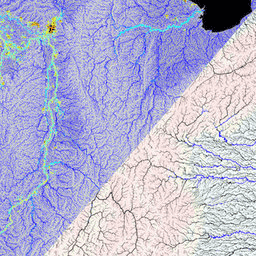
MERIT Hydro の補足的な可視化レイヤ dem elevation flow-direction hand hydrography hydrosheds
Datasets tagged flow-direction in Earth Engine
[null,null,[],[],["MERIT Hydro offers a global flow direction map with a 3 arc-second resolution, derived from MERIT DEM elevation data and water body datasets (G1WBM, GSWO, OpenStreetMap). It utilizes elevation, flow-direction, and hydrography data. It offers supplementary visualization layers that share the same data origins and tag categories, offering additional tools for understanding the hydrography data. The dataset focuses on mapping water flow direction globally.\n"]]