NAIP: برنامه ملی تصویربرداری کشاورزی 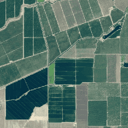
برنامه ملی تصاویر کشاورزی (NAIP) در طول فصول رشد کشاورزی در قاره آمریکا، تصاویر هوایی تهیه میکند. پروژههای NAIP هر ساله بر اساس بودجه موجود و چرخه تهیه تصاویر، قرارداد میبندند. از سال ۲۰۰۳، NAIP در یک چرخه ۵ ساله تهیه شد. سال ۲۰۰۸ ... تصاویر کشاورزی هایرز، ارتوفتوها، وزارت کشاورزی ایالات متحده مدل ارتفاع سایبان نئون (CHM) 
ارتفاع بالای تاج پوشش گیاهی بالای زمین لخت (مدل ارتفاع تاج پوشش گیاهی؛ CHM). CHM از ابر نقطهای لیدار NEON مشتق شده و با ایجاد یک سطح پیوسته از تخمینهای ارتفاع تاج پوشش گیاهی در کل دامنه مکانی نقشهبرداری لیدار تولید میشود. ... جنگل سایبانی هوابرد ، زیست توده جنگلی مرتفع، لیدار محتوای نیتروژن سایبان نئون (CNC) 
غلظت نیتروژن تاج پوشش گیاهی مدلسازی شده با مشاهدات شیمیایی برگ گیاه NEON کالیبره شده و با بازتاب جهتدار سطح L1، مشتق شده از طیفسنج تصویربرداری NEON (NIS) پیشبینی شده است. باندها شامل ۱) درصد نیتروژن تاج پوشش، ۲) عدم قطعیت مدل نیتروژن تاج پوشش، ۳) نتیجه طبقهبندی برای مدل سوزنی در مقابل مدل غیر سوزنی و ... جنگلهای سایهبان هوابرد، ارتفاعات ، نئون فراطیفی مدل ارتفاعی رقومی (DEM) NEON 
مدلهای دیجیتالی سطح (DSM) و زمین (DTM) که از دادههای لیدار NEON مشتق شدهاند. DSM: ویژگیهای سطحی (اطلاعات توپوگرافی با پوشش گیاهی و سازههای مصنوعی موجود). DTM: ارتفاع زمین لخت (اطلاعات توپوگرافی با حذف پوشش گیاهی و سازههای مصنوعی). تصاویر بر حسب متر بالاتر از میانگین سطح دریا ارائه شدهاند... نقشه ارتفاعی-توپوگرافی هوایی ، ارتفاعات جنگلی ، لیدار تصاویر دوربین NEON RGB 
تصاویر دوربین تصحیحشدهی قائم قرمز-سبز-آبی (RGB) با وضوح بالا، موزاییکی شده و با استفاده از نمونهبرداری مجدد نزدیکترین همسایه، روی یک شبکهی مکانی ثابت و یکنواخت خروجی داده میشوند؛ وضوح مکانی 0.1 متر است. دوربین دیجیتال بخشی از مجموعهای از ابزارها در پلتفرم رصد هوایی NEON (AOP) است که شامل ... نیز میشود. عکس ارتوفتو از جنگلهای مرتفع هوابرد نئون نئون -پرود-موتور زمین بازتاب دو جهته سطح نئون 
بازتاب دو جهته سطح NEON AOP یک محصول داده فراطیفی VSWIR (مرئی برای مادون قرمز موج کوتاه) است که شامل ۴۲۶ باند با طول موجهای از حدود ۳۸۰ نانومتر تا ۲۵۱۰ نانومتر است. بازتاب با ضریب ۱۰۰۰۰ مقیاسبندی شده است. طول موجهای بین ۱۳۴۰-۱۴۴۵ نانومتر و ۱۷۹۰-۱۹۵۵ نانومتر به صورت ... تنظیم شدهاند. جنگلهای مرتفع هوابرد ، نئون فراطیفی ، نئون-پرود-موتور زمین تصاویر ارتو عمومی Planet SkySat، چند طیفی 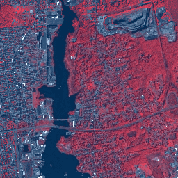
این دادهها از ماهوارههای SkySat شرکت Planet labs Inc. برای برنامه آزمایشی "Skybox for Good Beta" در سال ۲۰۱۵ و همچنین برای رویدادهای مختلف واکنش به بحران و چند پروژه دیگر جمعآوری شده است. این دادهها هم در مجموعه چند طیفی/پن باند ۵ باندی و هم در ... موجود است. تصاویر ماهوارهای سیارهای چندطیفی highres pansharpened از skysat تصاویر ارتو عمومی Planet SkySat، RGB 
این دادهها از ماهوارههای SkySat شرکت Planet labs Inc. برای برنامه آزمایشی "Skybox for Good Beta" در سال ۲۰۱۵ و همچنین برای رویدادهای مختلف واکنش به بحران و چند پروژه دیگر جمعآوری شده است. این دادهها هم در مجموعه چند طیفی/پن باند ۵ باندی و هم در ... موجود است. تصاویر ماهوارهای RGB سیاره با وضوح بالا از Skysat
Datasets tagged highres in Earth Engine
[null,null,[],[],["Planet Labs Inc. SkySat satellites collected data for the \"Skybox for Good Beta\" program in 2015 and crisis response events. This data is available in 5-band Multispectral/Pan and RGB collections. The National Agriculture Imagery Program (NAIP) acquires aerial imagery during U.S. agricultural growing seasons, beginning on a 5-year cycle in 2003. High-resolution RGB camera images from the NEON Airborne Observation Platform (AOP) are also available, featuring 0.1m spatial resolution.\n"]]