-
NAIP: National Agriculture Imagery Program

במסגרת התוכנית הלאומית לצילומי אוויר של חקלאות (NAIP) מתבצעים צילומי אוויר במהלך עונות הגידול החקלאי בארה"ב. הפרויקטים של NAIP מבוססים על מימון זמין ועל מחזור צילומי האוויר. החל משנת 2003, נתוני NAIP נרכשו במחזור של 5 שנים. בשנת 2008… agriculture highres imagery orthophotos usda -
מודל גובה חופת הצמרות של NEON (CHM)
גובה החלק העליון של החופה מעל קרקע חשופה (מודל גובה החופה; CHM). ה-CHM נגזר מענן הנקודות של NEON LiDAR ונוצר על ידי יצירת משטח רציף של הערכות גובה החופה בכל התחום המרחבי של סקר ה-LiDAR. ה… airborne canopy forest forest-biomass highres lidar -
NEON Canopy Nitrogen Content (CNC)

ריכוז החנקן בחופת הצמרות מחושב באמצעות מודל שמכויל לפי נתוני תצפיות על הכימיה של העלים בצמחים של NEON, ומוערך באמצעות נתוני החזרה כיוונית של פני השטח ברמה L1, שנגזרים מנתוני NEON Imaging Spectrometer (NIS). הפסים כוללים 1) אחוז החנקן בחופה, 2) אי הוודאות של מודל החנקן בחופה, 3) תוצאת הסיווג של מודל המחטים לעומת מודל ללא מחטים ו… airborne canopy forest highres hyperspectral neon -
מודל גובה דיגיטלי (DEM) של NEON

מודלים דיגיטליים של פני השטח (DSM) ושל השטח (DTM) שמבוססים על נתוני LiDAR של NEON. DSM: מאפייני פני השטח (מידע טופוגרפי עם צמחייה ומבנים מעשה ידי אדם). DTM: גובה פני השטח (מידע טופוגרפי ללא צמחייה ומבנים מעשה ידי אדם). התמונות מוצגות במטרים מעל ממוצע גובה פני הים … airborne dem elevation-topography forest highres lidar -
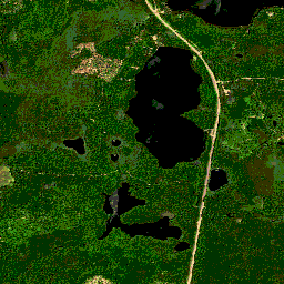
NEON RGB Camera Imagery

תמונות אורתורקטיפיקציה של מצלמה ברזולוציה גבוהה בצבעי אדום-ירוק-כחול (RGB), שנוצרו מפסיפס והוצאו לרשת מרחבית קבועה ואחידה באמצעות דגימה מחדש של השכן הקרוב ביותר. הרזולוציה המרחבית היא 0.1 מ'. המצלמה הדיגיטלית היא חלק מחבילת מכשירים בפלטפורמת התצפית האווירית (AOP) של NEON, שכוללת גם … airborne forest highres neon neon-prod-earthengine orthophoto -
NEON Surface Bidirectional Reflectance
הנתונים של NEON AOP Surface Bidirectional Reflectance הם נתונים היפרספקטרליים של VSWIR (אור נראה עד אינפרא אדום בגלים קצרים), שמכילים 426 פסים באורכי גל של ~380 nm עד 2510 nm. מקדם ההחזרה מוגדל פי 10,000. אורכי הגל בין 1,340 ל-1,445 ננומטר ובין 1,790 ל-1,955 ננומטר מוגדרים כ… airborne forest highres hyperspectral neon neon-prod-earthengine -
Planet SkySat Public Ortho Imagery, Multispectral

הנתונים האלה מלווייני SkySat של Planet labs Inc. נאספו במסגרת התוכנית הניסיונית Skybox for Good Beta בשנת 2015, וגם לצורך אירועים שונים של תגובה למצבי חירום וכמה פרויקטים אחרים. הנתונים זמינים גם באוסף של 5 רצועות רב-ספקטרליות/פאן, וגם ב… highres multispectral pansharpened planet satellite-imagery skysat -
Planet SkySat Public Ortho Imagery, RGB

הנתונים האלה מלווייני SkySat של Planet labs Inc. נאספו במסגרת התוכנית הניסיונית Skybox for Good Beta בשנת 2015, וגם לצורך אירועים שונים של תגובה למצבי חירום וכמה פרויקטים אחרים. הנתונים זמינים גם באוסף של 5 רצועות רב-ספקטרליות/פאן, וגם ב… highres pansharpened planet rgb satellite-imagery skysat
Datasets tagged highres in Earth Engine
[null,null,[],[],["Planet Labs Inc. SkySat satellites collected data for the \"Skybox for Good Beta\" program in 2015 and crisis response events. This data is available in 5-band Multispectral/Pan and RGB collections. The National Agriculture Imagery Program (NAIP) acquires aerial imagery during U.S. agricultural growing seasons, beginning on a 5-year cycle in 2003. High-resolution RGB camera images from the NEON Airborne Observation Platform (AOP) are also available, featuring 0.1m spatial resolution.\n"]]