-
שטח המנגרובים השנתי בעולם (1984-2023)

קבוצת הנתונים CGMD-Extent30 (דינמיקה רציפה של מנגרובים גלובליים – שטח שנתי של מנגרובים ברזולוציה של 30 מ') מספקת נתונים על השטח השנתי של מנגרובים גלובליים משנת 1984 עד 2023. קבוצת הנתונים מופצת כ-FeatureCollection יחיד ב-Earth Engine, כאשר כל מאפיין מייצג פוליגון של מנגרובים שמופה לשנה מסוימת. מערך הנתונים … annual coastal forest-biomass global landsat-derived landuse-landcover -
Global Annual Mangrove Fractional Canopy Cover (1984-2023)

קבוצת הנתונים הזו מספקת נתונים גלובליים שנתיים של כיסוי חלקי של חופת צמרות עצים (FCC) של מנגרובים ברזולוציה מרחבית של 30 מ' משנת 1984 עד 2023. הנתונים האלה תומכים בניתוחים בקנה מידה גדול של דינמיקת המנגרובים לאורך זמן, כולל פירוק והתחדשות של חופת הצמרות, הערכת פחמן כחול ומעקב אחרי מערכות אקולוגיות חופיות. FCC מכמת את החלק היחסי של כל Landsat … annual coastal forest-biomass global landsat-derived mangrove -
התפלגות גלובלית של יערות מנגרוב, גרסה 1 (2000)

מסד הנתונים הוכן באמצעות נתוני לוויין Landsat משנת 2000. יותר מ-1,000 סצנות Landsat שהתקבלו מ-USGS Earth Resources Observation and Science Center (EROS) סווגו באמצעות טכניקות היברידיות של סיווג תמונות דיגיטליות בפיקוח וללא פיקוח. מסד הנתונים הזה הוא הראשון, הכי … annual ciesin forest-biomass global landsat-derived mangrove -
Murray Global Tidal Wetland Change v1.0 (1999-2019)
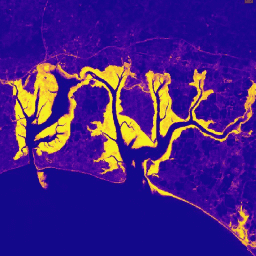
קבוצת הנתונים Murray Global Tidal Wetland Change Dataset מכילה מפות של היקף שטחי הביצות הגלובליות שמושפעות מגאות ושפל, והשינויים שחלו בהן. המפות נוצרו על סמך סיווג בשלושה שלבים שמטרתו הייתה (1) להעריך את ההתפלגות הגלובלית של שטחי ביצות שמושפעות מגאות ושפל (מוגדרות כביצות מלוחות, ביצות … coastal ecosystem intertidal landsat-derived mangrove murray
Datasets tagged mangrove in Earth Engine
[null,null,[],[],[]]