-
סיווג שינויים גלובליים באזורי גאות ושפל
קבוצת הנתונים Murray Global Intertidal Change Dataset מכילה מפות גלובליות של מערכות אקולוגיות של שטחי גאות ושפל, שנוצרו באמצעות סיווג בפיקוח של 707,528 תמונות מארכיון Landsat. כל פיקסל סווג כשטח בוצי, כמים קבועים או כסוג אחר, בהתבסס על מערך נתונים לאימון שמפוזר באופן גלובלי. ה… coastal google intertidal landsat-derived murray surface-ground-water -
מסכת נתונים של שינויים באזורי הגאות והשפל ברחבי העולם של Murray

קבוצת הנתונים Murray Global Intertidal Change Dataset מכילה מפות גלובליות של מערכות אקולוגיות של שטחי גאות ושפל, שנוצרו באמצעות סיווג בפיקוח של 707,528 תמונות מארכיון Landsat. כל פיקסל סווג כשטח בוצי, כמים קבועים או כסוג אחר, בהתבסס על מערך נתונים לאימון שמפוזר באופן גלובלי. ה… coastal google intertidal landsat-derived murray surface-ground-water -
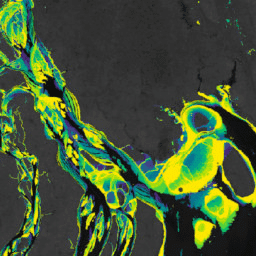
Murray Global Intertidal Change QA Pixel Count

קבוצת הנתונים Murray Global Intertidal Change Dataset מכילה מפות גלובליות של מערכות אקולוגיות של שטחי גאות ושפל, שנוצרו באמצעות סיווג בפיקוח של 707,528 תמונות מארכיון Landsat. כל פיקסל סווג כשטח בוצי, כמים קבועים או כסוג אחר, בהתבסס על מערך נתונים לאימון שמפוזר באופן גלובלי. ה… coastal google intertidal landsat-derived murray surface-ground-water -
Murray Global Tidal Wetland Change v1.0 (1999-2019)
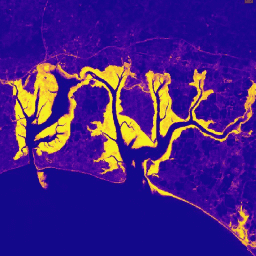
מערך הנתונים Murray Global Tidal Wetland Change Dataset מכיל מפות של היקף שטחי הביצות בעולם שמושפעים מגאות ושפל, ושל השינויים שחלו בהם. המפות פותחו על סמך סיווג בשלושה שלבים שמטרתו הייתה (1) להעריך את ההתפלגות הגלובלית של שטחי ביצות מושפעים מגאות ושפל (מוגדרים כביצות מלח, ביצות … coastal ecosystem intertidal landsat-derived mangrove murray
Datasets tagged coastal in Earth Engine
[null,null,[],[],["The content describes the Murray Global datasets, which map tidal wetland and intertidal flat ecosystems. The Tidal Wetland Change Dataset estimates the global distribution of tidal marshes and other tidal ecosystems. The Intertidal Change datasets classify pixels from 707,528 Landsat images into tidal flat, permanent water, or other categories. These datasets use a globally distributed training data to classify and map the global extent of intertidal areas and track changes.\n"]]