-
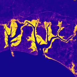
Diện tích rừng ngập mặn hằng năm trên toàn cầu (1984-2023)

Tập dữ liệu CGMD-Extent30 (Continuous Global Mangrove Dynamics – Diện tích rừng ngập mặn hằng năm ở độ phân giải 30 mét) cung cấp diện tích rừng ngập mặn hằng năm trên toàn cầu từ năm 1984 đến năm 2023. Tập dữ liệu này được phân phối dưới dạng một FeatureCollection duy nhất của Earth Engine, trong đó mỗi đối tượng đại diện cho một đa giác rừng ngập mặn được lập bản đồ cho một năm cụ thể. Tập dữ liệu … hằng năm ven biển rừng – sinh khối toàn cầu có nguồn gốc từ Landsat sử dụng đất – lớp phủ đất -
Độ che phủ tán rừng ngập mặn hằng năm trên toàn cầu (1984-2023)

Tập dữ liệu này cung cấp độ che phủ tán rừng ngập mặn hằng năm trên toàn cầu (FCC) ở độ phân giải không gian 30 mét từ năm 1984 đến năm 2023 để hỗ trợ phân tích quy mô lớn về động lực rừng ngập mặn trong dài hạn, bao gồm cả sự suy thoái và phục hồi tán rừng, đánh giá lượng carbon xanh và giám sát hệ sinh thái ven biển. FCC định lượng tỷ lệ của từng Landsat … rừng ven biển hằng năm sinh khối toàn cầu có nguồn gốc từ Landsat rừng ngập mặn -
Phân bố rừng ngập mặn trên toàn cầu, phiên bản 1 (2000)

Cơ sở dữ liệu này được chuẩn bị bằng dữ liệu vệ tinh Landsat từ năm 2000. Hơn 1.000 cảnh Landsat thu được từ Trung tâm Quan sát và Khoa học Tài nguyên Trái đất (EROS) của USGS đã được phân loại bằng các kỹ thuật phân loại hình ảnh kỹ thuật số có giám sát và không giám sát kết hợp. Cơ sở dữ liệu này là cơ sở dữ liệu đầu tiên, … hằng năm ciesin sinh khối toàn cầu có nguồn gốc từ Landsat rừng ngập mặn -
Thay đổi đối với vùng đất ngập nước do thuỷ triều trên toàn cầu của Murray, phiên bản 1.0 (1999-2019)
Tập dữ liệu Thay đổi đối với vùng đất ngập nước do thuỷ triều trên toàn cầu của Murray chứa bản đồ về phạm vi toàn cầu của vùng đất ngập nước do thuỷ triều và sự thay đổi đối với vùng đất này. Các bản đồ này được phát triển từ quy trình phân loại gồm 3 giai đoạn nhằm (i) ước tính sự phân bố toàn cầu của vùng đất ngập nước do thuỷ triều (được định nghĩa là đầm lầy do thuỷ triều, … hệ sinh thái ven biển hệ sinh thái vùng gian triều có nguồn gốc từ Landsat rừng ngập mặn murray
Datasets tagged mangrove in Earth Engine
[null,null,[],[],[]]