-
זיהוי יומי של אירועי שריפה ב-GlobFire על סמך MCD64A1
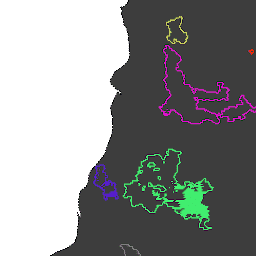
גבולות השריפות מבוססים על מערך הנתונים MODIS MCD64A1. הנתונים חושבו על סמך אלגוריתם שמסתמך על קידוד במבנה גרף של קשר בין אזורים שנשרפו במרחב ובזמן. לכל שריפה יש מספר ייחודי שמזהה את האירוע. area burnt disaster fire globfire mcd64a1 -
GlobFire Final Fire Event Detection Based on MCD64A1

גבולות השריפות מבוססים על מערך הנתונים MODIS MCD64A1. הנתונים חושבו על סמך אלגוריתם שמסתמך על קידוד במבנה גרף של קשר בין אזורים שנשרפו במרחב ובזמן. לכל שריפה יש מספר ייחודי שמזהה את האירוע. area burnt disaster fire globfire mcd64a1 -
MCD64A1.061 MODIS Burned Area Monthly Global 500m

מוצר הנתונים המשולב של Terra ו-Aqua MCD64A1 Version 6.1 Burned Area הוא מוצר חודשי גלובלי ברשת של 500 מ' שמכיל מידע על אזורים שרופים ואיכות לכל פיקסל. הגישה למיפוי אזורים שרופים ב-MCD64A1 משתמשת בתמונות של השתקפות פני השטח של MODIS ברזולוציה של 500 מ' בשילוב עם תצפיות של שריפות פעילות של MODIS ברזולוציה של קילומטר אחד. האלגוריתם … burn change-detection fire geophysical global mcd64a1
Datasets tagged mcd64a1 in Earth Engine
[null,null,[],[],["The content describes three datasets related to fire and burned areas, all utilizing the MODIS MCD64A1 dataset. Two datasets, \"GlobFire Daily\" and \"GlobFire Final,\" provide fire boundaries, computed by an algorithm using the space-time relationships between burned patches, each with a unique identifier. The third dataset, \"MCD64A1.061,\" is a monthly global product with 500m resolution, detailing burned areas and quality using surface reflectance imagery and active fire observations.\n"]]