-
MCD64A1을 기반으로 한 GlobFire 일일 화재 이벤트 감지

MODIS 데이터 세트 MCD64A1을 기반으로 한 화재 경계입니다. 이 데이터는 불에 탄 지역의 패치 간 시공간 관계를 그래프 구조로 인코딩하는 알고리즘을 기반으로 계산되었습니다. 각 화재에는 이벤트를 식별하는 고유한 번호가 있습니다. area burnt disaster fire globfire mcd64a1 -
MCD64A1을 기반으로 한 GlobFire 최종 화재 이벤트 감지

MODIS 데이터 세트 MCD64A1을 기반으로 한 화재 경계입니다. 이 데이터는 불에 탄 지역의 패치 간 시공간 관계를 그래프 구조로 인코딩하는 알고리즘을 기반으로 계산되었습니다. 각 화재에는 이벤트를 식별하는 고유한 번호가 있습니다. area burnt disaster fire globfire mcd64a1 -
MCD64A1.061 MODIS 소실 지역 월별 전 세계 500m
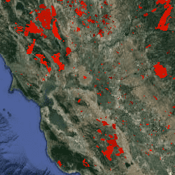
Terra와 Aqua를 결합한 MCD64A1 버전 6.1 소실 지역 데이터 제품은 픽셀별 소실 지역 및 품질 정보를 포함하는 월별 글로벌 그리드 500m 제품입니다. MCD64A1 소실 지역 매핑 접근 방식은 1km MODIS 활성 화재 관측과 결합된 500m MODIS 표면 반사율 이미지를 사용합니다. 알고리즘은 … burn change-detection fire geophysical global mcd64a1
Datasets tagged mcd64a1 in Earth Engine
[null,null,[],[],["The content describes three datasets related to fire and burned areas, all utilizing the MODIS MCD64A1 dataset. Two datasets, \"GlobFire Daily\" and \"GlobFire Final,\" provide fire boundaries, computed by an algorithm using the space-time relationships between burned patches, each with a unique identifier. The third dataset, \"MCD64A1.061,\" is a monthly global product with 500m resolution, detailing burned areas and quality using surface reflectance imagery and active fire observations.\n"]]