-
MERIT DEM: 다중 오류가 삭제된 개선된 지형 DEM
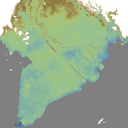
MERIT DEM은 기존 DEM (NASA SRTM3 DEM, JAXA AW3D DEM, Viewfinder Panoramas DEM)에서 주요 오류 구성요소를 삭제하여 생성된 3초 해상도 (적도에서 약 90m)의 고정밀 글로벌 DEM입니다. MERIT DEM은 절대 편향, 스트라이프 노이즈, 스페클 노이즈를 분리하고 … dem elevation elevation-topography merit topography -
MERIT Hydro: 글로벌 수로학 데이터 세트
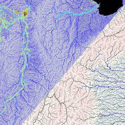
MERIT Hydro는 MERIT DEM 고도 데이터 및 수역 데이터 세트 (G1WBM, GSWO, OpenStreetMap) 버전 1.0.3에서 파생된 3초 해상도 (적도에서 약 90m)의 새로운 글로벌 흐름 방향 지도입니다. MERIT Hydro에는 새로운 … dem elevation hydrography hydrosheds merit river-width -
MERIT Hydro: 보조 시각화 레이어

MERIT Hydro의 보조 시각화 레이어 hydrography hydrosheds merit river-width surface-ground-water upstream-drainage-area
Datasets tagged merit in Earth Engine
[null,null,[],[],["MERIT DEM is a high-accuracy global Digital Elevation Model (DEM) with a 3 arc-second resolution. It was created by removing errors from existing DEMs. MERIT Hydro, derived from MERIT DEM, is a global flow direction map, also at 3 arc-second resolution, that uses water body datasets. Supplementary visualization layers for MERIT Hydro are also available. The main actions include the creation of these datasets and the enhancement of resolution and correction of errors.\n"]]