-
GLIMS 2023: 宇宙から見た全球陸氷測定
地球から氷河を測定する国際的なイニシアチブである GLIMS(Global Land Ice Measurements from Space)は、世界に 20 万基あると推定される氷河を繰り返し調査することを目的としています。このプロジェクトでは、氷河の面積、形状、表面速度、雪線の測定など、陸氷のグローバルな包括的なインベントリを作成することを目指しています。 cryosphere glacier glims ice landcover nasa -
GLIMS Current: 宇宙から見た全球陸氷の測定
地球から氷河を測定する国際的なイニシアチブである GLIMS(Global Land Ice Measurements from Space)は、世界に 20 万基あると推定される氷河を繰り返し調査することを目的としています。このプロジェクトでは、氷河の面積、形状、表面速度、雪線の測定など、陸氷のグローバルな包括的なインベントリを作成することを目指しています。 cryosphere glacier glims ice landcover nasa -
MOD10A1.061 Terra 積雪範囲(1 日間、世界、500 m)
MOD10A1 V6.1 積雪日別世界 500 m プロダクトには、積雪、積雪のアルベド、積雪率、品質評価(QA)データが含まれています。積雪データは、正規化差分積雪指数(NDSI)などの基準テストを使用する雪地図作成アルゴリズムに基づいています。全般 反射率 氷圏 日次 地理物理学 地球規模 MODIS -
MOD10A2.061 Terra Snow Cover 8-Day L3 Global 500m
MOD10A2 は、Terra 衛星の MODIS から取得した積雪データセットです。このデータセットは、8 日間の最大積雪量を 500 m の解像度で報告します。8 日間の合成期間が選択されたのは、それが地上トラックの正確な繰り返しであるためです。 凍結圏 1 日間 地理物理学 地球全体 modis nasa -
MYD10A1.061 Aqua Snow Cover Daily Global 500m
MYD10A1 V6 積雪日別世界 500 m プロダクトには、積雪、積雪のアルベド、積雪率、品質評価(QA)データが含まれています。積雪データは、正規化差分積雪指数(NDSI)などの基準テストを使用する雪地図作成アルゴリズムに基づいています。全般 反射率 水域 氷圏 1 日間 地理物理学 地球規模
Datasets tagged nsidc in Earth Engine
[null,null,[],[[["\u003cp\u003eGLIMS repeatedly surveys the world's glaciers to create a comprehensive inventory, including measurements of glacier area, geometry, surface velocity, and snow line.\u003c/p\u003e\n"],["\u003cp\u003eMOD10A1.061 provides daily global snow cover information, including snow albedo and fractional snow cover, using a Normalized Difference Snow Index (NDSI).\u003c/p\u003e\n"],["\u003cp\u003eMYD10A1.061 offers similar daily global snow cover data as MOD10A1.061 but is derived from the Aqua satellite instead of Terra.\u003c/p\u003e\n"]]],["GLIMS aims to inventory 200,000 glaciers globally, measuring area, geometry, surface velocity, and snow line. MOD10A1 provides daily global snow cover data, including albedo and fractional cover, at 500m resolution, using an NDSI-based algorithm. MOD10A2 tracks the maximum snow cover extent over eight-day periods at 500m resolution. MYD10A1 similarly offers daily global snow data, including albedo and fractional snow cover, at 500m, and is based on an NDSI algorithm.\n"],null,["# Datasets tagged nsidc in Earth Engine\n\n-\n\n |--------------------------------------------------------------------------------------------------------------------------------------------------------------------------------------------------------------------------------------------------------------------------------------------------------------------------------|\n | [### GLIMS 2023: Global Land Ice Measurements From Space](/earth-engine/datasets/catalog/GLIMS_20230607) |\n | Global Land Ice Measurements from Space (GLIMS) is an international initiative with the goal of repeatedly surveying the world's estimated 200,000 glaciers. The project seeks to create a globally comprehensive inventory of land ice, including measurements of glacier area, geometry, surface velocity, and snow line ... |\n | [cryosphere](/earth-engine/datasets/tags/cryosphere) [glacier](/earth-engine/datasets/tags/glacier) [glims](/earth-engine/datasets/tags/glims) [ice](/earth-engine/datasets/tags/ice) [landcover](/earth-engine/datasets/tags/landcover) [nasa](/earth-engine/datasets/tags/nasa) |\n\n-\n\n |--------------------------------------------------------------------------------------------------------------------------------------------------------------------------------------------------------------------------------------------------------------------------------------------------------------------------------|\n | [### GLIMS Current: Global Land Ice Measurements From Space](/earth-engine/datasets/catalog/GLIMS_current) |\n | Global Land Ice Measurements from Space (GLIMS) is an international initiative with the goal of repeatedly surveying the world's estimated 200,000 glaciers. The project seeks to create a globally comprehensive inventory of land ice, including measurements of glacier area, geometry, surface velocity, and snow line ... |\n | [cryosphere](/earth-engine/datasets/tags/cryosphere) [glacier](/earth-engine/datasets/tags/glacier) [glims](/earth-engine/datasets/tags/glims) [ice](/earth-engine/datasets/tags/ice) [landcover](/earth-engine/datasets/tags/landcover) [nasa](/earth-engine/datasets/tags/nasa) |\n\n-\n\n |-----------------------------------------------------------------------------------------------------------------------------------------------------------------------------------------------------------------------------------------------------------------------------------------------------|\n | [### 
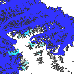
MOD10A1.061 Terra Snow Cover Daily Global 500m](/earth-engine/datasets/catalog/MODIS_061_MOD10A1) |\n | The MOD10A1 V6.1 Snow Cover Daily Global 500m product contains snow cover, snow albedo, fractional snow cover, and quality assessment (QA) data. Snow cover data are based on a snow mapping algorithm that employs a Normalized Difference Snow Index (NDSI) and other criteria tests. General ... |\n | [albedo](/earth-engine/datasets/tags/albedo) [cryosphere](/earth-engine/datasets/tags/cryosphere) [daily](/earth-engine/datasets/tags/daily) [geophysical](/earth-engine/datasets/tags/geophysical) [global](/earth-engine/datasets/tags/global) [modis](/earth-engine/datasets/tags/modis) |\n\n-\n\n |-----------------------------------------------------------------------------------------------------------------------------------------------------------------------------------------------------------------------------------------------------------------------------------------|\n | [### MOD10A2.061 Terra Snow Cover 8-Day L3 Global 500m](/earth-engine/datasets/catalog/MODIS_061_MOD10A2) |\n | MOD10A2 is a snow cover dataset from the MODIS on the Terra satellite. The dataset reports the maximum snow cover extent during an eight-day period at the resolution of 500 m. An eight-day compositing period was chosen because that is the exact ground track repeat ... |\n | [cryosphere](/earth-engine/datasets/tags/cryosphere) [daily](/earth-engine/datasets/tags/daily) [geophysical](/earth-engine/datasets/tags/geophysical) [global](/earth-engine/datasets/tags/global) [modis](/earth-engine/datasets/tags/modis) [nasa](/earth-engine/datasets/tags/nasa) |\n\n-\n\n |---------------------------------------------------------------------------------------------------------------------------------------------------------------------------------------------------------------------------------------------------------------------------------------------------|\n | [### MYD10A1.061 Aqua Snow Cover Daily Global 500m](/earth-engine/datasets/catalog/MODIS_061_MYD10A1) |\n | The MYD10A1 V6 Snow Cover Daily Global 500m product contains snow cover, snow albedo, fractional snow cover, and quality assessment (QA) data. Snow cover data are based on a snow mapping algorithm that employs a Normalized Difference Snow Index (NDSI) and other criteria tests. General ... |\n | [albedo](/earth-engine/datasets/tags/albedo) [aqua](/earth-engine/datasets/tags/aqua) [cryosphere](/earth-engine/datasets/tags/cryosphere) [daily](/earth-engine/datasets/tags/daily) [geophysical](/earth-engine/datasets/tags/geophysical) [global](/earth-engine/datasets/tags/global) |"]]