-
GLIMS 2023: Đo lường băng trên đất liền trên toàn cầu từ không gian

Global Land Ice Measurements from Space (GLIMS) (Đo lường băng trên đất liền toàn cầu từ không gian) là một sáng kiến quốc tế nhằm mục tiêu khảo sát nhiều lần khoảng 200.000 sông băng trên thế giới. Dự án này hướng đến việc tạo ra một danh mục toàn diện trên toàn cầu về băng trên đất liền, bao gồm cả các phép đo diện tích, hình học, vận tốc bề mặt và đường tuyết của sông băng… cryosphere glacier glims ice landcover nasa -
GLIMS Current: Global Land Ice Measurements From Space (Đo lường băng trên đất liền trên toàn cầu từ không gian)
Global Land Ice Measurements from Space (GLIMS) (Đo lường băng trên đất liền toàn cầu từ không gian) là một sáng kiến quốc tế nhằm mục tiêu khảo sát nhiều lần khoảng 200.000 sông băng trên thế giới. Dự án này hướng đến việc tạo ra một danh mục toàn diện trên toàn cầu về băng trên đất liền, bao gồm cả các phép đo diện tích, hình học, vận tốc bề mặt và đường tuyết của sông băng… cryosphere glacier glims ice landcover nasa -
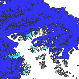
MOD10A1.061 Terra Snow Cover Daily Global 500m

Sản phẩm MOD10A1 V6.1 về Lớp phủ tuyết toàn cầu hằng ngày 500m chứa dữ liệu về lớp phủ tuyết, suất phản chiếu của tuyết, tỷ lệ lớp phủ tuyết và đánh giá chất lượng (QA). Dữ liệu về độ phủ tuyết dựa trên thuật toán lập bản đồ tuyết sử dụng Chỉ số tuyết chênh lệch chuẩn hoá (NDSI) và các tiêu chí kiểm thử khác. Chung … albedo cryosphere daily geophysical global modis -
MOD10A2.061 Terra Snow Cover 8-Day L3 Global 500m

MOD10A2 là một tập dữ liệu về lớp phủ tuyết từ MODIS trên vệ tinh Terra. Tập dữ liệu này báo cáo phạm vi bao phủ tuyết tối đa trong khoảng thời gian 8 ngày ở độ phân giải 500 m. Chúng tôi chọn khoảng thời gian kết hợp là 8 ngày vì đó là khoảng thời gian chính xác để lặp lại đường bay trên mặt đất... cryosphere daily geophysical global modis nasa -
MYD10A1.061 Aqua Snow Cover Daily Global 500m

Sản phẩm MYD10A1 V6 Snow Cover Daily Global 500m chứa dữ liệu về độ che phủ tuyết, suất phản chiếu của tuyết, tỷ lệ độ che phủ tuyết và đánh giá chất lượng (QA). Dữ liệu về độ phủ tuyết dựa trên thuật toán lập bản đồ tuyết sử dụng Chỉ số tuyết chênh lệch chuẩn hoá (NDSI) và các tiêu chí kiểm thử khác. Chung … albedo aqua cryosphere daily geophysical global
Datasets tagged nsidc in Earth Engine
[null,null,[],[],["GLIMS aims to inventory 200,000 glaciers globally, measuring area, geometry, surface velocity, and snow line. MOD10A1 provides daily global snow cover data, including albedo and fractional cover, at 500m resolution, using an NDSI-based algorithm. MOD10A2 tracks the maximum snow cover extent over eight-day periods at 500m resolution. MYD10A1 similarly offers daily global snow data, including albedo and fractional snow cover, at 500m, and is based on an NDSI algorithm.\n"]]