-
NICFI 卫星数据计划:用于热带森林监测的基础地图 - 非洲
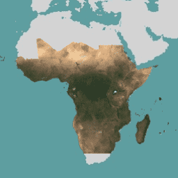
此图片集提供对热带地区的高分辨率卫星监测数据,主要目的是减少和扭转热带森林的损失,从而有助于应对气候变化、保护生物多样性、促进森林再生、恢复和增强,以及推动可持续发展,所有这些都… basemaps forest nicfi planet planet-nicfi publisher-dataset -
NICFI 卫星数据计划热带森林监测基本地图 - 美洲
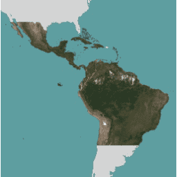
此图片集提供对热带地区的高分辨率卫星监测数据,主要目的是减少和扭转热带森林的损失,从而有助于应对气候变化、保护生物多样性、促进森林再生、恢复和增强,以及推动可持续发展,所有这些都… basemaps forest nicfi planet planet-nicfi publisher-dataset -
NICFI 卫星数据计划热带森林监测基本地图 - 亚洲
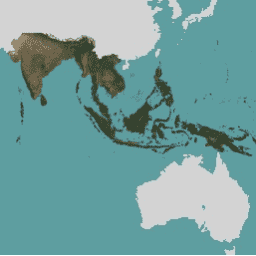
此图片集提供对热带地区的高分辨率卫星监测数据,主要目的是减少和扭转热带森林的损失,从而有助于应对气候变化、保护生物多样性、促进森林再生、恢复和增强,以及推动可持续发展,所有这些都… basemaps forest nicfi planet planet-nicfi publisher-dataset -
Planet SkySat 公共正射影像,多光谱

这些数据来自 Planet Labs Inc. 的 SkySat 卫星,于 2015 年为实验性“Skybox for Good Beta”计划以及各种灾难应对活动和其他一些项目收集。该数据以 5 波段多光谱/全色影像集的形式提供,还以… highres multispectral pansharpened planet satellite-imagery skysat -
Planet SkySat 公共正射影像,RGB

这些数据来自 Planet Labs Inc. 的 SkySat 卫星,于 2015 年为实验性“Skybox for Good Beta”计划以及各种灾难应对活动和其他一些项目收集。该数据以 5 波段多光谱/全色影像集的形式提供,还以… highres pansharpened planet rgb satellite-imagery skysat
Datasets tagged planet in Earth Engine
[null,null,[],[],[]]