-
基于 Sentinel-1 的动态地表水范围 (DSWx-S1) V1

此数据集包含来自 Sentinel-1 的 3 级动态 OPERA 地表水范围 (DSWX-S1)。DSWx-S1 可提供近乎全球的陆地地表水范围地理映射,空间分辨率为 30 米,采用军事网格参考系统 (MGRS) 网格系统,时间重访频率介于… 地球物理 nasa opera sentinel1-derived surface surface-ground-water -
ESA WorldCereal 10 m v100

欧洲空间局 (ESA) WorldCereal 10 米 2021 年产品套件包含全球范围的年度和季节性作物地图及其相关置信度。这些数据是作为 ESA-WorldCereal 项目的一部分生成的。如需详细了解这些产品的内容以及用于…的方法,请参阅… 农业 哥白尼 农作物 欧洲航天局 全球 土地覆盖 -
ESA WorldCereal Active Cropland 10 m v100

欧洲空间局 (ESA) WorldCereal Active Cropland 10 m 2021 产品套件包含全球范围的季节性活跃耕地标记。这些数据是作为 ESA-WorldCereal 项目的一部分生成的。有效农田产品表示被识别为临时作物的像素是否已积极… 农业 哥白尼 农作物 欧洲航天局 全球 土地覆盖 -
ESA WorldCover 10 米 v100
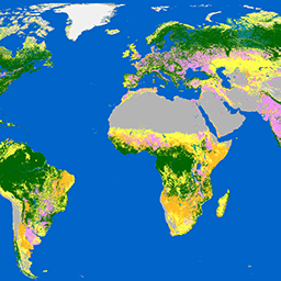
欧洲空间局 (ESA) WorldCover 10 m 2020 产品基于 Sentinel-1 和 Sentinel-2 数据,提供 2020 年全球土地覆被地图,分辨率为 10 米。WorldCover 产品包含 11 种地表覆被类别,在 … 框架下生成 esa landcover landuse landuse-landcover sentinel1-derived sentinel2-derived -
ESA WorldCover 10m v200

欧洲空间局 (ESA) WorldCover 10 m 2021 产品基于 Sentinel-1 和 Sentinel-2 数据,提供 2021 年全球土地覆被地图,分辨率为 10 米。WorldCover 产品包含 11 种地表覆被类别,在 … 框架下生成 esa landcover landuse landuse-landcover sentinel1-derived sentinel2-derived -
EUCROPMAP

欧洲作物类型地图,基于 Sentinel-1 和 LUCAS Copernicus 2018 年实地观测数据(针对 2018 年),以及 Sentinel-1、Sentinel-2 和辅助数据与 LUCAS Copernicus 2022 年观测数据的组合(针对 2022 年)。该数据集基于独特的 LUCAS 2018 Copernicus 实地调查,是首个… agriculture crop eu jrc lucas sentinel1-derived -
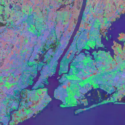
全球季节性 Sentinel-1 干涉相干性和后向散射 V2019 后向散射

该数据集是首个此类空间表示形式的数据集,可呈现多季节全球 C 波段合成孔径雷达 (SAR) 干涉重复通过相干性和后向散射特征。覆盖范围包括从北纬 82 度到南纬 79 度的陆地和冰盖。该数据集源自多时相… backscatter earth-big-data jpl nasa polarization radar -
全球季节性 Sentinel-1 干涉相干性和后向散射 V2019 相干性

该数据集是首个此类空间表示形式的数据集,可呈现多季节全球 C 波段合成孔径雷达 (SAR) 干涉重复通过相干性和后向散射特征。覆盖范围包括从北纬 82 度到南纬 79 度的陆地和冰盖。该数据集源自多时相… earth-big-data jpl nasa polarization radar sar -
全球季节性 Sentinel-1 干涉相干性和后向散射 V2019 衰减模型参数

该数据集是首个此类空间表示形式的数据集,可呈现多季节全球 C 波段合成孔径雷达 (SAR) 干涉重复通过相干性和后向散射特征。覆盖范围包括从北纬 82 度到南纬 79 度的陆地和冰盖。该数据集源自多时相… earth-big-data jpl nasa polarization radar sar -
全球季节性 Sentinel-1 干涉相干性和后向散射 V2019 入射叠掩阴影

该数据集是首个此类空间表示形式的数据集,可呈现多季节全球 C 波段合成孔径雷达 (SAR) 干涉重复通过相干性和后向散射特征。覆盖范围包括从北纬 82 度到南纬 79 度的陆地和冰盖。该数据集源自多时相… earth-big-data jpl nasa polarization radar sar -
OPERA Radiometric Terrain-Corrected SAR Backscatter from Sentinel-1 Static Layers V1.0

此产品包含与 OPERA 辐射校正地形的 Sentinel-1 SAR 反向散射数据集关联的静态雷达几何图层。由于 S1 任务的轨道管较窄,雷达几何层(例如入射角、局部入射角、观测次数和 RTC 面积归一化因子 (ANF))… jpl nasa opera sar satellite-imagery sentinel1-derived -
OPERA 辐射地形校正的 Sentinel-1 SAR 反向散射 V1.0

此产品包含根据地形归一化的雷达后向散射。它可将与地面散射物体的物理属性(例如表面粗糙度和土壤湿度和/或植被)相关的信号映射出来。OPERA RTC-S1 产品源自哥白尼 Sentinel-1 干涉宽幅 (IW) … backscatter jpl nasa opera polarization radar -
卫星嵌入 V1
Google Satellite Embedding 数据集是一个全球性的、随时可供分析的地理空间嵌入内容集合。此数据集中的每个 10 米像素都是一个 64 维表示形式(或“嵌入向量”),用于对该像素及其周围的地表状况的时间轨迹进行编码,这些轨迹是通过各种地球观测… annual global google landsat-derived satellite-imagery sentinel1-derived -
World Settlement Footprint 2015

世界聚落足迹 (WSF) 2015 是一张分辨率为 10 米的二元掩码,用于勾勒全球人类聚落的范围,该掩码是根据 2014-2015 年的多时相 Landsat-8 和 Sentinel-1 影像(分别处理了约 217,000 个和约 107,000 个场景)得出的。人类聚居地的时空动态变化… landcover landsat-derived population sentinel1-derived settlement urban
Datasets tagged sentinel1-derived in Earth Engine
[null,null,[],[],[]]