-
TIGER: Stany USA według spisu ludności z 2016 r.
Zbiór danych TIGER Biura Statystycznego Stanów Zjednoczonych zawiera granice z 2016 r. głównych jednostek administracyjnych w Stanach Zjednoczonych. Oprócz 50 stanów Biuro spisu ludności traktuje jako stany także Dystrykt Kolumbii, Portoryko i wszystkie wyspy (Samoa Amerykańskie, … spis granice infrastruktury stan stany tabela tygrys -
TIGER: Stany spisowe w USA 2018
Zbiór danych TIGER amerykańskiego urzędu spisu ludności zawiera granice głównych jednostek administracyjnych Stanów Zjednoczonych z 2018 r. Oprócz 50 stanów Biuro spisu ludności traktuje jako stany także Dystrykt Kolumbii, Portoryko i wszystkie wyspy (Samoa Amerykańskie, … spis granice infrastruktury stan stany tabela tygrys
Datasets tagged state in Earth Engine
[null,null,[],[[["\u003cp\u003eThe US Census Bureau TIGER dataset provides boundaries for the primary governmental divisions of the United States, including states, the District of Columbia, Puerto Rico, and island areas.\u003c/p\u003e\n"],["\u003cp\u003eThe dataset is available for the years 2016 and 2018.\u003c/p\u003e\n"],["\u003cp\u003eBoundaries encompass the fifty states as well as the District of Columbia, Puerto Rico, and island areas like American Samoa, the Commonwealth of the Northern Mariana Islands, Guam, and the U.S. Virgin Islands.\u003c/p\u003e\n"]]],[],null,["# Datasets tagged state in Earth Engine\n\n-\n\n |---------------------------------------------------------------------------------------------------------------------------------------------------------------------------------------------------------------------------------------------------------------------------------------------------------------|\n | [### TIGER: US Census States 2016
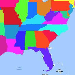
](/earth-engine/datasets/catalog/TIGER_2016_States) |\n | The United States Census Bureau TIGER dataset contains the 2016 boundaries for the primary governmental divisions of the United States. In addition to the fifty states, the Census Bureau treats the District of Columbia, Puerto Rico, and each of the island areas (American Samoa, the ... |\n | [census](/earth-engine/datasets/tags/census) [infrastructure-boundaries](/earth-engine/datasets/tags/infrastructure-boundaries) [state](/earth-engine/datasets/tags/state) [states](/earth-engine/datasets/tags/states) [table](/earth-engine/datasets/tags/table) [tiger](/earth-engine/datasets/tags/tiger) |\n\n-\n\n |---------------------------------------------------------------------------------------------------------------------------------------------------------------------------------------------------------------------------------------------------------------------------------------------------------------|\n | [### TIGER: US Census States 2018](/earth-engine/datasets/catalog/TIGER_2018_States) |\n | The United States Census Bureau TIGER dataset contains the 2018 boundaries for the primary governmental divisions of the United States. In addition to the fifty states, the Census Bureau treats the District of Columbia, Puerto Rico, and each of the island areas (American Samoa, the ... |\n | [census](/earth-engine/datasets/tags/census) [infrastructure-boundaries](/earth-engine/datasets/tags/infrastructure-boundaries) [state](/earth-engine/datasets/tags/state) [states](/earth-engine/datasets/tags/states) [table](/earth-engine/datasets/tags/table) [tiger](/earth-engine/datasets/tags/tiger) |"]]