Zbiór danych TIGER amerykańskiego Biura Spisu Ludności zawiera granice z 2016 r. dla głównych podziałów administracyjnych Stanów Zjednoczonych. Oprócz 50 stanów Biuro Spisu Ludności traktuje Dystrykt Kolumbii, Portoryko i każdy z obszarów wyspiarskich (Samoa Amerykańskie, Wspólnotę Marianów Północnych, Guam i Wyspy Dziewicze Stanów Zjednoczonych) jako odpowiedniki stanów na potrzeby prezentacji danych.
Każda funkcja reprezentuje stan lub jego odpowiednik.
Opis obszaru prawnego lub statystycznego dla stanu
MTFCC
CIĄG ZNAKÓW
Kod klasy obiektu MAF/TIGER (=G4000)
NAZWA
CIĄG ZNAKÓW
Nazwa stanu
REGION
CIĄG ZNAKÓW
Kod regionu
STATEFP
CIĄG ZNAKÓW
Kod FIPS stanu
STATENS
CIĄG ZNAKÓW
Kod GNIS stanu
STUSPS
CIĄG ZNAKÓW
Skrót stanu w US Postal Service
Warunki korzystania z usługi
Amerykańskie Biuro Spisu Ludności udostępnia niektóre ze swoich publicznych danych w formacie czytelnym dla maszyn za pomocą interfejsu API. Cała zawartość, dokumentacja, kod i powiązane materiały udostępniane za pomocą interfejsu API podlegają niniejszym warunkom.
Cytaty
Cytowania:
W przypadku tworzenia raportów, publikacji, nowych zbiorów danych, produktów pochodnych lub usług na podstawie zbioru danych użytkownicy powinni cytować US Census Bureau.
Zbiór danych TIGER amerykańskiego Biura Spisu Ludności zawiera granice podstawowych jednostek administracyjnych Stanów Zjednoczonych z 2016 r. Oprócz 50 stanów Biuro Spisu Ludności traktuje Dystrykt Kolumbii, Portoryko i każdy z obszarów wyspiarskich (Samoa Amerykańskie, Wspólnota Marianów Północnych…
[null,null,[],[[["\u003cp\u003eThe TIGER/2016/States dataset provides 2016 boundaries for the primary governmental divisions of the United States, including states and state equivalents.\u003c/p\u003e\n"],["\u003cp\u003eThe dataset includes attributes such as land and water area, geographic identifiers, and census region codes.\u003c/p\u003e\n"],["\u003cp\u003eUsers should cite the US Census Bureau when using this data for reports, publications, or derived products.\u003c/p\u003e\n"],["\u003cp\u003eThis dataset can be visualized and analyzed using Earth Engine, a platform for geospatial data analysis.\u003c/p\u003e\n"],["\u003cp\u003eThe dataset is available as a FeatureCollection and a FeatureView for optimized visualization in Earth Engine.\u003c/p\u003e\n"]]],[],null,["# TIGER: US Census States 2016\n\nDataset Availability\n: 2016-01-01T00:00:00Z--2017-01-02T00:00:00Z\n\nDataset Provider\n:\n\n\n [United States Census Bureau](https://www.census.gov/programs-surveys/geography/guidance/tiger-data-products-guide.html)\n\nTags\n:\n[census](/earth-engine/datasets/tags/census) [infrastructure-boundaries](/earth-engine/datasets/tags/infrastructure-boundaries) [state](/earth-engine/datasets/tags/state) [states](/earth-engine/datasets/tags/states) [table](/earth-engine/datasets/tags/table) [tiger](/earth-engine/datasets/tags/tiger) [us](/earth-engine/datasets/tags/us) \n\n#### Description\n\nThe United States Census Bureau TIGER dataset contains the 2016 boundaries\nfor the primary governmental divisions of the United States. In addition\nto the fifty states, the Census Bureau treats the District of Columbia,\nPuerto Rico, and each of the island areas (American Samoa, the Commonwealth\nof the Northern Mariana Islands, Guam, and the U.S. Virgin Islands) as the\nstatistical equivalents of States for the purpose of data presentation.\nEach feature represents a state or state equivalent.\n\nFor full technical details on all TIGER 2016 products, see the [TIGER\ntechnical documentation](https://www2.census.gov/geo/pdfs/maps-data/data/tiger/tgrshp2016/TGRSHP2016_TechDoc.pdf).\n\n### Table Schema\n\n**Table Schema**\n\n| Name | Type | Description |\n|----------|--------|----------------------------------------------|\n| ALAND | DOUBLE | Land area |\n| AWATER | DOUBLE | Water area |\n| DIVISION | STRING | Division code |\n| FUNCSTAT | STRING | Functional Status |\n| GEOID | STRING | State identifier; state FIPS code |\n| INTPTLAT | STRING | Internal point latitude |\n| INTPTLON | STRING | Internal point longitude |\n| LSAD | STRING | Legal/statistical area description for state |\n| MTFCC | STRING | MAF/TIGER feature class code (=G4000) |\n| NAME | STRING | State name |\n| REGION | STRING | Region code |\n| STATEFP | STRING | State FIPS code |\n| STATENS | STRING | State GNIS code |\n| STUSPS | STRING | US Postal Service state abbreviation |\n\n### Terms of Use\n\n**Terms of Use**\n\nThe U.S. Census Bureau offers some of its public data\nin machine-readable format via an Application Programming Interface\n(API). All of the content, documentation, code and related materials\nmade available through the API are subject to [these terms and\nconditions](https://www.census.gov/data/developers/about/terms-of-service.html).\n\n### Citations\n\nCitations:\n\n- For the creation of any reports, publications, new data sets, derived\n products, or services resulting from the data set, users should\n [cite the US Census Bureau](https://www.census.gov/about/policies/citation.html).\n\n### Explore with Earth Engine\n\n| **Important:** Earth Engine is a platform for petabyte-scale scientific analysis and visualization of geospatial datasets, both for public benefit and for business and government users. Earth Engine is free to use for research, education, and nonprofit use. To get started, please [register for Earth Engine access.](https://console.cloud.google.com/earth-engine)\n\n### Code Editor (JavaScript)\n\n```javascript\n
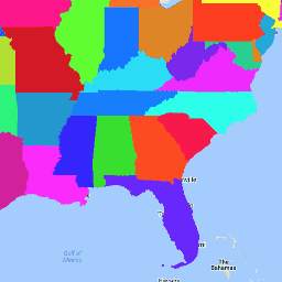
var dataset = ee.FeatureCollection('TIGER/2016/States');\nvar visParams = {\n palette: ['purple', 'blue', 'green', 'yellow', 'orange', 'red'],\n min: 500000000,\n max: 5e+11,\n opacity: 0.8,\n};\nvar image = ee.Image().float().paint(dataset, 'ALAND');\nMap.setCenter(-99.844, 37.649, 5);\nMap.addLayer(image, visParams, 'TIGER/2016/States');\nMap.addLayer(dataset, null, 'for Inspector', false);\n```\n[Open in Code Editor](https://code.earthengine.google.com/?scriptPath=Examples:Datasets/TIGER/TIGER_2016_States)\n\n### Visualize as a FeatureView\n\n\nA `FeatureView` is a view-only, accelerated representation of a\n`FeatureCollection`. For more details, visit the\n[`FeatureView` documentation.](/earth-engine/guides/featureview_overview)\n| **Important:** Earth Engine is a platform for petabyte-scale scientific analysis and visualization of geospatial datasets, both for public benefit and for business and government users. Earth Engine is free to use for research, education, and nonprofit use. To get started, please [register for Earth Engine access.](https://console.cloud.google.com/earth-engine)\n\n### Code Editor (JavaScript)\n\n```javascript\nvar fvLayer = ui.Map.FeatureViewLayer('TIGER/2016/States_FeatureView');\n\nvar visParams = {\n opacity: 0.8,\n color: {\n property: 'ALAND',\n mode: 'linear',\n palette: ['purple', 'blue', 'green', 'yellow', 'orange', 'red'],\n min: 5e8,\n max: 5e11\n }\n};\n\nfvLayer.setVisParams(visParams);\nfvLayer.setName('US census states');\n\nMap.setCenter(-99.844, 37.649, 5);\nMap.add(fvLayer);\n```\n[Open in Code Editor](https://code.earthengine.google.com/?scriptPath=Examples:Datasets/TIGER/TIGER_2016_States_FeatureView) \n[TIGER: US Census States 2016](/earth-engine/datasets/catalog/TIGER_2016_States) \nThe United States Census Bureau TIGER dataset contains the 2016 boundaries for the primary governmental divisions of the United States. In addition to the fifty states, the Census Bureau treats the District of Columbia, Puerto Rico, and each of the island areas (American Samoa, the Commonwealth of the Northern Mariana ... \nTIGER/2016/States, census,infrastructure-boundaries,state,states,table,tiger,us \n2016-01-01T00:00:00Z/2017-01-02T00:00:00Z \n-14.69 -180 71.567 -64.435 \nGoogle Earth Engine \nhttps://developers.google.com/earth-engine/datasets\n\n- [](https://doi.org/https://www.census.gov/programs-surveys/geography/guidance/tiger-data-products-guide.html)\n- [](https://doi.org/https://developers.google.com/earth-engine/datasets/catalog/TIGER_2016_States)"]]