-
FAO GAUL 500m Simplified: Global Administrative Unit Layers 2015, First-Level Administrative Units

Ta wersja zbioru danych GAUL jest uproszczona do 500 m. Baza danych Global Administrative Unit Layers (GAUL) zawiera i rozpowszechnia najlepsze dostępne informacje o jednostkach administracyjnych we wszystkich krajach świata, przyczyniając się do standaryzacji zbioru danych przestrzennych reprezentujących jednostki administracyjne. … borders departments fao gaul infrastructure-boundaries provinces -
FAO GAUL: Global Administrative Unit Layers 2015, First-Level Administrative Units
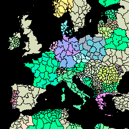
Baza danych Global Administrative Unit Layers (GAUL) zawiera i rozpowszechnia najlepsze dostępne informacje o jednostkach administracyjnych we wszystkich krajach świata, przyczyniając się do standaryzacji zbioru danych przestrzennych reprezentujących jednostki administracyjne. GAUL zawsze zawiera warstwy globalne z ujednoliconym… borders departments fao gaul infrastructure-boundaries provinces -
TIGER: US Census States 2016
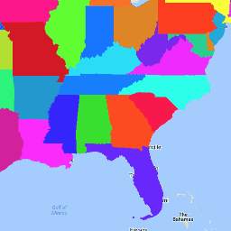
Zbiór danych TIGER amerykańskiego Biura Spisu Ludności zawiera granice podstawowych podziałów administracyjnych Stanów Zjednoczonych z 2016 r. Oprócz 50 stanów Biuro Spisów Ludności traktuje Dystrykt Kolumbii, Portoryko i każdy z obszarów wyspiarskich (Samoa Amerykańskie, … census infrastructure-boundaries state states table tiger -
TIGER: stany USA według spisu ludności z 2018 r.

Zbiór danych TIGER amerykańskiego biura ewidencji ludności zawiera granice podstawowych podziałów administracyjnych Stanów Zjednoczonych z 2018 r. Oprócz 50 stanów Biuro Spisów Ludności traktuje Dystrykt Kolumbii, Portoryko i każdy z obszarów wyspiarskich (Samoa Amerykańskie, … census infrastructure-boundaries state states table tiger
Datasets tagged states in Earth Engine
[null,null,[],[],["The Global Administrative Unit Layers (GAUL) datasets compile and share information on administrative units worldwide, standardizing spatial data representation. One version is simplified to 500m. The US Census Bureau TIGER datasets provide the 2016 and 2018 boundaries for primary US governmental divisions, including states, the District of Columbia, Puerto Rico, and island areas.\n"]]