-
AG100: ASTER 전역 방사율 데이터 세트 100미터 V003

Advanced Spaceborne Thermal Emission and Reflection Radiometer Global Emissivity Database (ASTER-GED)는 캘리포니아 공과대학의 미국 항공우주국 (NASA) 제트추진연구소 (JPL)에서 개발했습니다. 이 제품에는 모든 5개의 ASTER 열 적외선 … aster elevation emissivity geophysical infrared jpl -
ASTER L1T Radiance

참고: ASTER 기기의 기술적 문제로 인해 2024년 11월 28일과 2025년 1월 16일 사이에 데이터 수집에 차이가 있습니다. 자세한 내용은 USGS 공지사항을 참고하세요. Advanced Spaceborne Thermal Emission and Reflection Radiometer (ASTER)는 … aster 이미지 nasa nir 복사량 위성 이미지 -
FIRMS: Fire Information for Resource Management System(리소스 관리 시스템을 위한 화재 정보)
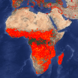
Earth Engine 버전의 산림 자원 관리 시스템 (FIRMS) 데이터 세트에는 래스터화된 형태의 LANCE 화재 감지 제품이 포함되어 있습니다. 거의 실시간 (NRT) 활성 화재 위치는 표준 MODIS MOD14/MYD14 화재 및 열 이상 제품을 사용하여 LANCE에서 처리됩니다. 각 … eosdis fire firms geophysical hotspot lance -
VJ114IMGTDL_NRT 일일 래스터: VIIRS (NOAA-20) 375m 활성 화재

NOAA-20 (JPSS-1) 가시광선 적외선 이미징 방사계 (VIIRS) 활성 화재 감지 제품은 기기의 375m 공칭 해상도 데이터를 기반으로 합니다. 다른 더 거친 해상도 (≥ 1km) 위성 화재 감지 제품과 비교할 때 개선된 375m 데이터는 비교적 작은 화재에 대해 더 큰 반응을 제공합니다. eosdis fire firms geophysical hotspot lance -
VNP14IMGTDL_NRT 일일 래스터: VIIRS (S-NPP) 375m 대역 활성 화재

Suomi NPP 가시광선 적외선 이미징 방사계 (VIIRS) 활성 화재 감지 제품은 기기의 375m 공칭 해상도 데이터를 기반으로 합니다. 다른 더 낮은 해상도 (≥ 1km) 위성 화재 감지 제품과 비교할 때 개선된 375m 데이터는 비교적 작은 화재에 대해 더 큰 반응을 제공합니다. eosdis fire firms geophysical hotspot lance
Datasets tagged thermal in Earth Engine
[null,null,[],[],[]]