
Im folgenden Codebeispiel wird gezeigt, wie Sie eine Polylinie hinzufügen und im
3D-Raum positionieren, indem Sie die
addPolyline
Methode aufrufen. Wenn Sie dieses Codebeispiel verwenden möchten, folgen Sie der Anleitung unter
3D-Karte einrichten und einer App hinzufügen, um Ihr
Android Studio-Projekt mit einer einfachen 3D-Karte einzurichten. Fügen Sie dann der Datei MainActivity.kt den folgenden Code hinzu:
// Add imports
import com.google.android.gms.maps3d.model.latLngAltitude
...
// Add to the onMap3DViewReady method, after the googleMap3D object has been initialized
googleMap3D.setCamera(
camera {
center = latLngAltitude {
latitude = 40.029349
longitude = -105.300354
altitude = 1833.9
}
heading = 326.0
tilt = 75.0
range = 3757.0
}
)
internal val trailLocations = """
40.0201040, -105.2976640
40.0201080, -105.2976450
40.0201640, -105.2975120
40.0202200, -105.2973740
40.0202500, -105.2972760
40.0202960, -105.2971410
40.0203080, -105.2970990
40.0203320, -105.2970070
40.0203640, -105.2969400
40.0203710, -105.2969250
40.0203770, -105.2969220
40.0203910, -105.2969130
40.0203940, -105.2969120
40.0204200, -105.2969130
40.0204630, -105.2968910
40.0205270, -105.2968280
40.0206030, -105.2967570
40.0206590, -105.2966100
40.0206990, -105.2964870
""".trimIndent().split("\n").map {
val (lat, lng) = it.split(",")
latLngAltitude {
latitude = lat.toDouble()
longitude = lng.toDouble()
altitude = 0.0 // The trail will be clamped to the ground
}
}
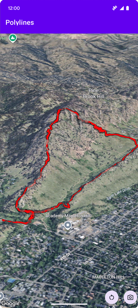
val trailPolylineOptions = polylineOptions {
coordinates = trailLocations
strokeColor = Color.RED
strokeWidth = 7.0
altitudeMode = AltitudeMode.CLAMP_TO_GROUND
zIndex = 5
drawsOccludedSegments = true
}
googleMap3D.addPolyline(trailPolylineOptions)
Auf Klickereignisse für Polylinien warten
Wenn Sie auf Klickereignisse für eine Polylinie warten möchten, rufen Sie setClickListener für das Polylinienobjekt auf. Im folgenden Beispiel wird gezeigt, wie Sie einen Klick-Listener für eine Polylinie festlegen:
polyline.setClickListener {
    lifecycleScope.launch(Dispatchers.Main) {
        Toast.makeText(this@PolylinesActivity, "Hiking time!", Toast.LENGTH_SHORT).show()
    }
}
Der Klick-Handler wird nicht im Hauptthread (oder UI-Thread) ausgeführt. Wenn Sie Änderungen an der Benutzeroberfläche vornehmen möchten, z. B. eine Toast-Nachricht anzeigen, müssen Sie zum Hauptthread wechseln. In Kotlin können Sie dazu lifecycleScope.launch(Dispatchers.Main) verwenden.