- ডেটাসেট উপলব্ধতা
- 2010-02-01T00:00:00Z-2010-02-01T00:00:00Z
- ডেটাসেট প্রদানকারী
- জিওসায়েন্স অস্ট্রেলিয়া
- ট্যাগ
বর্ণনা
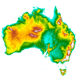
স্মুথড ডিজিটাল এলিভেশন মডেল (DEM-S) 2000 সালের ফেব্রুয়ারিতে NASA দ্বারা অর্জিত SRTM ডেটা থেকে প্রাপ্ত হয়েছিল। DEM-S ভূ-পৃষ্ঠের টপোগ্রাফি প্রতিনিধিত্ব করে (উদ্ভিদ বৈশিষ্ট্য ব্যতীত) এবং শব্দ কমাতে এবং পৃষ্ঠের আকৃতির উপস্থাপনা উন্নত করতে মসৃণ করা হয়েছে। একটি অভিযোজিত প্রক্রিয়া পার্বত্য অঞ্চলের তুলনায় চ্যাপ্টা এলাকায় বেশি মসৃণ করে এবং কম কোলাহলপূর্ণ এলাকার তুলনায় কোলাহলপূর্ণ এলাকায় বেশি মসৃণ করে।
এই DEM-S স্থানীয় ভূখণ্ডের আকৃতির গুণাবলী যেমন ঢাল, দৃষ্টিভঙ্গি এবং বক্রতা গণনাকে সমর্থন করে যা শব্দের কারণে 1 সেকেন্ডের ডিইএম থেকে নির্ভরযোগ্যভাবে প্রাপ্ত করা যায়নি।
অপ্রত্যাশিত নেতিবাচক মান সহ বেশ কয়েকটি এলাকা রয়েছে: ক্যানবেরার কাছাকাছি (150.443044, -35.355281) -55 এর মান সহ এবং পশ্চিম অস্ট্রেলিয়ায় (124.84, -16.44) -43 এর কাছাকাছি।
ব্যান্ড
পিক্সেল সাইজ
30.92 মিটার
ব্যান্ড
| নাম | ইউনিট | মিন | সর্বোচ্চ | পিক্সেল সাইজ | বর্ণনা |
|---|---|---|---|---|---|
elevation | মি | -73.31* | 2224.32* | মিটার | উচ্চতা |
ব্যবহারের শর্তাবলী
ব্যবহারের শর্তাবলী
উদ্ধৃতি
Geoscience Australia, 2015. LiDAR 5 মিটার গ্রিড থেকে প্রাপ্ত অস্ট্রেলিয়ার ডিজিটাল এলিভেশন মডেল (DEM)। জিওসায়েন্স অস্ট্রেলিয়া, ক্যানবেরা।
আর্থ ইঞ্জিন দিয়ে অন্বেষণ করুন
কোড এডিটর (জাভাস্ক্রিপ্ট)
var dataset = ee.Image('AU/GA/DEM_1SEC/v10/DEM-S');
var elevation = dataset.select('elevation');
var elevationVis = {
  min: -10.0,
  max: 1300.0,
  palette: [
    '3ae237', 'b5e22e', 'd6e21f', 'fff705', 'ffd611', 'ffb613', 'ff8b13',
    'ff6e08', 'ff500d', 'ff0000', 'de0101', 'c21301', '0602ff', '235cb1',
    '307ef3', '269db1', '30c8e2', '32d3ef', '3be285', '3ff38f', '86e26f'
  ],
};
Map.setCenter(133.95, -24.69, 5);
Map.addLayer(elevation, elevationVis, 'Elevation');