- 데이터 세트 제공
- 2015-01-01T00:00:00Z–2016-01-01T00:00:00Z
- 데이터 세트 출처
- Deutsches Zentrum für Luft- und Raumfahrt (DLR)
- 태그
설명
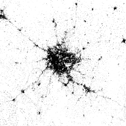
World Settlement Footprint (WSF) 2015는 2014~2015년 다중 시간 Landsat-8 및 Sentinel-1 이미지 (각각 약 217,000개 및 약 107,000개의 장면이 처리됨)를 통해 파생된 전 세계 인간 거주지의 범위를 나타내는 10m 해상도 이진 마스크입니다.
시간에 따른 인적 거주지의 시간적 역학은 다른 모든 비거주지 정보 클래스와는 다릅니다. 따라서 선택한 시간 간격에서 관심 지역에 사용할 수 있는 모든 다중 시간 이미지에 대해 다음 항목의 주요 시간 통계 (즉, 시간 평균, 최소, 최대 등)가 추출됩니다.
- 레이더 데이터의 경우 원래 역산란 값
- 광학 이미지의 경우 클라우드 마스크를 실행한 후 파생된 다양한 스펙트럼 지수 (예: 식생 지수, 건물 지수 등)
그런 다음 지원 벡터 머신 (SVM)을 기반으로 하는 다양한 분류 체계가 광학 및 레이더 시간적 특징에 각각 별도로 적용되고, 마지막으로 두 출력이 적절하게 결합됩니다.
레이어의 높은 정확성과 신뢰성을 정량적으로 평가하기 위해 Google과 협력하여 방대한 양의 그라운드 트루스 샘플 (예: 900,000개)을 크라우드소싱 사진 해석을 통해 라벨링했습니다. 통계적으로 강력하고 투명한 프로토콜은 현재 문헌에서 권장하는 최신 사례에 따라 정의되었습니다.
모든 기술 세부정보는 게시물을 참고하세요.
대역
대역
픽셀 크기: 10m (모든 밴드)
| 이름 | 최소 | 최대 | 픽셀 크기 | 설명 |
|---|---|---|---|---|
settlement |
255 | 255 | 10미터 | 인간 거주 지역 |
이용약관
이용약관
인용
Marconcini, M., Metz-Marconcini, A., Üreyen, S., Palacios-Lopez, D., Hanke, W., Bachofer, F., Zeidler, J., Esch, T., Gorelick, N., Kakarla, A., Paganini, M., Strano, E. (2020). 인간이 거주하는 지역을 나타내는 World Settlement Footprint 2015. Scientific Data, 7(1), 1~14. doi:10.1038/s41597-020-00580-5
DOI
Earth Engine으로 탐색
코드 편집기(JavaScript)
var dataset = ee.Image('DLR/WSF/WSF2015/v1');

var opacity = 0.75;
var blackBackground = ee.Image(0);
Map.addLayer(blackBackground, null, 'Black background', true, opacity);

var visualization = {
  min: 0,
  max: 255,
};
Map.addLayer(dataset, visualization, 'Human settlement areas');

Map.setCenter(90.45, 23.7, 7);