-
Sentinel-1의 동적 지표수 범위 (DSWx-S1) V1

이 데이터 세트에는 Sentinel-1의 레벨 3 동적 OPERA 지표수 범위 (DSWX-S1)가 포함되어 있습니다. DSWx-S1은 군사 그리드 참조 시스템 (MGRS) 그리드 시스템에서 30미터의 공간 해상도로 육지의 지표수 범위를 거의 전 세계적으로 지리적 매핑하며, 시간적 재방문 빈도는 … 지구물리학 nasa opera sentinel1-derived surface surface-ground-water -
ESA WorldCereal 10 m v100

유럽우주국 (ESA) WorldCereal 10m 2021 제품군은 전 세계 규모의 연간 및 계절별 작물 지도와 관련 신뢰도로 구성됩니다. 이 데이터는 ESA-WorldCereal 프로젝트의 일환으로 생성되었습니다. 이러한 제품의 콘텐츠와 …에 사용된 방법론에 대한 자세한 내용은 농업 copernicus 농작물 esa 전 세계 토지 피복 -
ESA WorldCereal Active Cropland 10 m v100
유럽우주국 (ESA) WorldCereal Active Cropland 10m 2021 제품군에는 전 세계 규모의 계절별 활성 농지 마커가 포함되어 있습니다. 이 데이터는 ESA-WorldCereal 프로젝트의 일환으로 생성되었습니다. 활성 농지 제품은 임시 작물로 식별된 픽셀이 활성 상태인지 여부를 나타냅니다. 농업 copernicus 농작물 esa 전 세계 토지 피복 -
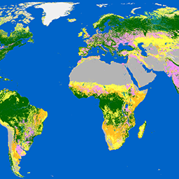
ESA WorldCover 10m v100

유럽우주국 (ESA) WorldCover 10m 2020 제품은 Sentinel-1 및 Sentinel-2 데이터를 기반으로 10m 해상도의 2020년 전 세계 토지 피복 지도를 제공합니다. WorldCover 제품에는 11개의 토지 피복 분류가 포함되어 있으며, … esa landcover landuse landuse-landcover sentinel1-derived sentinel2-derived -
ESA WorldCover 10m v200
유럽우주국 (ESA) WorldCover 10m 2021 제품은 Sentinel-1 및 Sentinel-2 데이터를 기반으로 10m 해상도의 2021년 전 세계 토지 피복 지도를 제공합니다. WorldCover 제품에는 11개의 토지 피복 분류가 포함되어 있으며, … esa landcover landuse landuse-landcover sentinel1-derived sentinel2-derived -
EUCROPMAP
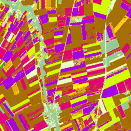
2018년의 경우 Sentinel-1 및 LUCAS Copernicus 2018 현장 관측을 기반으로 하고 2022년의 경우 Sentinel-1, Sentinel-2, 보조 데이터와 LUCAS Copernicus 2022 관측을 조합하여 만든 유럽 작물 유형 지도입니다. 고유한 LUCAS 2018 Copernicus 현장 조사에 기반한 이 데이터 세트는 … agriculture crop eu jrc lucas sentinel1-derived -
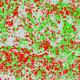
Global Seasonal Sentinel-1 Interferometric Coherence and Backscatter V2019 Backscatter(전 세계 계절별 Sentinel-1 간섭계 일관성 및 후방산란 V2019 후방산란)

이 데이터 세트는 다계절, 전 세계 C-밴드 합성 개구 레이더(SAR) 간섭계 반복 통과 일관성 및 후방산란 특징의 최초 공간 표현입니다. 커버리지는 북위 82도에서 남위 79도까지의 육지와 빙상으로 구성됩니다. 이 데이터 세트는 2019년 12월 1일부터 2020년 11월 30일까지 광대역 간섭계… 후방 산란 지구 빅데이터 jpl nasa 편광 레이더 -
Global Seasonal Sentinel-1 Interferometric Coherence and Backscatter V2019 Coherence(전 세계 계절별 Sentinel-1 간섭계 일관성 및 후방산란 V2019 일관성)

이 데이터 세트는 다계절, 전 세계 C-밴드 합성 개구 레이더(SAR) 간섭계 반복 통과 일관성 및 후방산란 특징의 최초 공간 표현입니다. 커버리지는 북위 82도에서 남위 79도까지의 육지와 빙상으로 구성됩니다. 이 데이터 세트는 2019년 12월 1일부터 2020년 11월 30일까지 광대역 간섭계… earth-big-data jpl nasa 편광 레이더 sar -
Global Seasonal Sentinel-1 Interferometric Coherence and Backscatter V2019 Decay Model Parameters(전 세계 계절별 Sentinel-1 간섭계 일관성 및 후방산란 V2019 감쇠 모델 파라미터)

이 데이터 세트는 다계절, 전 세계 C-밴드 합성 개구 레이더(SAR) 간섭계 반복 통과 일관성 및 후방산란 특징의 최초 공간 표현입니다. 커버리지는 북위 82도에서 남위 79도까지의 육지와 빙상으로 구성됩니다. 이 데이터 세트는 2019년 12월 1일부터 2020년 11월 30일까지 광대역 간섭계… earth-big-data jpl nasa 편광 레이더 sar -
Global Seasonal Sentinel-1 Interferometric Coherence and Backscatter V2019 Incidence Layover Shadow

이 데이터 세트는 다계절, 전 세계 C-밴드 합성 개구 레이더(SAR) 간섭계 반복 통과 일관성 및 후방산란 특징의 최초 공간 표현입니다. 커버리지는 북위 82도에서 남위 79도까지의 육지와 빙상으로 구성됩니다. 이 데이터 세트는 2019년 12월 1일부터 2020년 11월 30일까지 광대역 간섭계… earth-big-data jpl nasa 편광 레이더 sar -
Sentinel-1 정적 레이어 V1.0의 OPERA 방사량으로 지형 보정된 SAR 후방산란

이 제품에는 Sentinel-1 데이터 세트의 OPERA 방사량으로 지형 보정된 SAR 후방산란과 관련된 정적 레이더 지오메트리 레이어가 포함되어 있습니다. S1 미션의 좁은 궤도 튜브로 인해 입사각, 지역 입사각, 룩 수, RTC 영역 정규화 요소 (ANF)와 같은 레이더 기하학적 레이어가 … jpl nasa opera sar 위성 이미지 sentinel1 파생 -
Sentinel-1의 OPERA 방사량으로 지형 보정된 SAR 후방산란 V1.0

이 제품은 지형에 관해 정규화된 레이더 후방산란으로 구성됩니다. 지면 산란 물체의 물리적 속성(예: 표면 거칠기, 토양 수분, 식물)과 관련된 신호를 매핑합니다. OPERA RTC-S1 제품은 Copernicus Sentinel-1 Interferometric Wide (IW) … 후방 산란 jpl nasa opera 편광 레이더 -
위성 삽입 V1
Google 위성 삽입 데이터 세트는 학습된 지리 공간 삽입의 전 세계 분석 준비 컬렉션입니다. 이 데이터 세트의 각 10미터 픽셀은 다양한 지구 관측 위성에서 측정한 해당 픽셀 및 주변의 지표 조건의 시간적 궤적을 인코딩하는 64차원 표현 또는 '임베딩 벡터'입니다. annual global google landsat-derived satellite-imagery sentinel1-derived -
World Settlement Footprint 2015
World Settlement Footprint (WSF) 2015는 2014~2015년 다중 시간 Landsat-8 및 Sentinel-1 이미지 (각각 약 217,000개 및 약 107,000개의 장면이 처리됨)를 사용하여 전 세계 인간 거주지의 범위를 나타내는 10m 해상도 이진 마스크입니다. The temporal dynamics of human settlements … 토지 피복 Landsat 파생 인구 Sentinel1 파생 정착지 도시
Datasets tagged sentinel1-derived in Earth Engine
[null,null,[],[],[]]