- זמינות קבוצת הנתונים
- 2006-01-24T00:00:00Z–2011-05-12T00:00:00Z
- מפיק מערך הנתונים
- JAXA Earth Observation Research Center
- תגים
תיאור
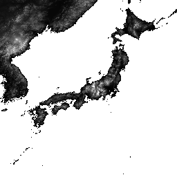
ALOS World 3D - 30m (או AW3D30) הוא מערך נתונים של מודל פני שטח דיגיטלי (DSM) גלובלי ברזולוציה אופקית של כ-30 מטרים (רשת של שניית קשת). מערך הנתונים מבוסס על מערך הנתונים של DSM (גרסת רשת של 5 מטרים) של World 3D Topographic Data. פרטים נוספים זמינים בתיעוד של מערך הנתונים.
מערך הנתונים הזה כולל נתונים מגרסאות 3.1, 4.0 ו-4.1.
גרסה 4.1 (אפריל 2024): במסגרת העדכון המשמעותי הזה פורסמו 19,051 משבצות שמכסות אזורים גלובליים (לא כולל אנטארקטיקה ויפן). הוא כולל נתונים משלימים חדשים למילוי פערים, ומתקן אנומליות חלקיות שנמצאו בגרסאות 3.1 ו-3.2, וגם ממלא מחדש פערים. כדי לעדכן משבצות ספציפיות בגרסה 4.1, צריך להשתמש במסנן גרסה 4.1 במשבצות המפה או לעיין בתיאור הפורמט העדכני.
גרסה 4.0 (אפריל 2023): בעדכון הזה נוספו 1,886 משבצות, והוא שיפר את האזורים בקווי רוחב נמוכים ובינוניים ואת האזורים מדרום לקו רוחב 60.
השינויים העיקריים כוללים: 1. נתונים משלימים חדשים למילוי פערים. 2. תיקון של חריגות חלקיות ומילוי מחדש של חללים (2 משבצות). 3. עדכנו את קווי החוף באזורים שמדרום לקו רוחב 60 (44 משבצות). 4. מסכת המים של הים הכספי הושבתה והושלמו נתוני גובה (54 קטעי מפה). 5. חולצו ותוקנו אזורים חדשים של אנומליות חלקיות בדרום אמריקה (1,786 משבצות). 6. למידע מפורט על משבצות של גרסה 4.0, אפשר להשתמש במסנן גרסה 4.0 במשבצות של מפות או לעיין בתיאור הפורמט.
גרסה 3.2, שפורסמה בינואר 2021, היא גרסה משופרת שנוצרה בעקבות בחינה מחדש של הפורמט באזור בקווי רוחב גבוהים, נתונים משניים ושיטת העיבוד. באזורים בקווי רוחב גבוהים, נעשה שימוש במרווחים שונים בין הפיקסלים לכל אזור בקו הרוחב. נתוני קו החוף, שהם אחד ממערכי הנתונים המשניים, השתנו, ונעשה שימוש בנתונים משלימים חדשים. בנוסף, נעשה שימוש בגרסה 3 של AW3D כמקור נתונים עבור יפן. בנוסף, שיפרנו את השיטה לזיהוי ערכים חריגים בתהליך.
הגובה ב-AW3D DSM מחושב בתהליך של התאמת תמונות, שבו נעשה שימוש בזוג סטריאו של תמונות אופטיות. עננים, שלג וקרח מזוהים באופן אוטומטי במהלך העיבוד, ופרטי המסכה מוחלים עליהם. עם זאת, לפעמים נשארות נקודות לא תואמות, במיוחד באזורים שמסביב לעננים, לשלג ולאזורי קרח (או בקצוות שלהם), וזה גורם לשגיאות מסוימות בגובה ב-DSM הסופי.
תחום תדרים
תחום תדרים
גודל הפיקסל: 30 מטרים (כל הפסים)
| שם | מינימום | מקסימום | גודל הפיקסל | תיאור | |||||||||||||||||||||||||||||||||||||||||||||||||||||||||||||||||||||||||||||||||||||||||||||||
|---|---|---|---|---|---|---|---|---|---|---|---|---|---|---|---|---|---|---|---|---|---|---|---|---|---|---|---|---|---|---|---|---|---|---|---|---|---|---|---|---|---|---|---|---|---|---|---|---|---|---|---|---|---|---|---|---|---|---|---|---|---|---|---|---|---|---|---|---|---|---|---|---|---|---|---|---|---|---|---|---|---|---|---|---|---|---|---|---|---|---|---|---|---|---|---|---|---|---|---|
DSM |
-433* | 8768* | 30 מטרים | הגובה מעל פני הים. 16 ביט חתום. גובה (במטרים) שהומר מהגובה האליפסואידי על סמך ITRF97 ו-GRS80, באמצעות מודל הגיאואיד EGM96†1. |
|||||||||||||||||||||||||||||||||||||||||||||||||||||||||||||||||||||||||||||||||||||||||||||||
STK |
1* | 54* | 30 מטרים | מספר הערימה של יחידת הסצנה DSM שנעשה בה שימוש בהפקת DSM. הנתונים ברצועה נגזרים על ידי דגימה מחדש של מספר הערימה עבור DSM ברזולוציה של 5 מ' לרזולוציה של 30 מ'. |
|||||||||||||||||||||||||||||||||||||||||||||||||||||||||||||||||||||||||||||||||||||||||||||||
MSK |
30 מטרים | מסיכה של 8 ביט לרצועה. |
|||||||||||||||||||||||||||||||||||||||||||||||||||||||||||||||||||||||||||||||||||||||||||||||||
תנאים והגבלות
תנאים והגבלות
קבוצת הנתונים הזו זמינה לשימוש ללא תשלום בהתאם לתנאים שמפורטים בתנאי השימוש במודל הדיגיטלי של פני השטח של ALOS.
ציטוטים ביבליוגרפיים
- T. Tadono, H. Ishida, F. Oda, S. Naito, K. Minakawa, H. איוואמוטו
- Precise Global DEM Generation By ALOS PRISM, ISPRS Annals of the Photogrammetry, Remote Sensing and Spatial Information Sciences, Vol.II-4, pp.71-76, 2014. קובץ PDF
י. Takaku, T. Tadono, K. Tsutsui : Generation of High Resolution Global DSM from ALOS PRISM, The International Archives of the Photogrammetry, Remote Sensing and Spatial Information Sciences, Vol. XL-4, pp.243-248, ISPRS, 2014. קובץ PDF
י. Takaku, T. Tadono, K. Tsutsui, M. Ichikawa : Validation of 'AW3D' Global DSM Generated from ALOS PRISM, ISPRS Annals of the Photogrammetry, Remote Sensing and Spatial Information Sciences, Vol.III-4, pp.25-31, 2016. קובץ PDF
T. Tadono, H. Nagai, H. Ishida, F. Oda, S. Naito, K. Minakawa, H. Iwamoto : Initial Validation of the 30 m-mesh Global Digital Surface Model Generated by ALOS PRISM, The International Archives of the Photogrammetry, Remote Sensing and Spatial Information Sciences, ISPRS, Vol. XLI-B4, pp.157-162, 2016. קובץ PDF
י. Takaku, T. Tadono, M. Doutsu, F. Ohgushi, and H. Kai, : "Updates of 'AW3D30' ALOS Global Digital Surface Model in Antarctica with Other Open Access Datasets", Int. Arch. Photogramm. Remote Sens. Spatial Inf. Sci., XLIII-B4-2021, 401-408, 2021. קובץ PDF
סיור עם פלטפורמת Earth Engine
עורך קוד (JavaScript)
var dataset = ee.ImageCollection('JAXA/ALOS/AW3D30/V4_1');
var elevation = dataset.select('DSM');
var elevationVis = {
  min: 0,
  max: 5000,
  palette: ['0000ff', '00ffff', 'ffff00', 'ff0000', 'ffffff']
};
Map.setCenter(138.73, 35.36, 11);
Map.addLayer(elevation, elevationVis, 'Elevation');

// Reproject an image mosaic using a projection from one of the image tiles,
// rather than using the default projection returned by .mosaic().
var proj = elevation.first().select(0).projection();
var slopeReprojected = ee.Terrain.slope(elevation.mosaic()
                             .setDefaultProjection(proj));
Map.addLayer(slopeReprojected, {min: 0, max: 45}, 'Slope');