- در دسترس بودن مجموعه دادهها
- 2020-12-31T00:00:00Z–2020-12-31T00:00:01Z
- تولیدکننده مجموعه داده
- مرکز تحقیقات مشترک، کمیسیون اروپا
- کادانس
- ۱ سال
- برچسبها
- یودر
توضیحات
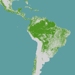
نقشه جهانی پوشش جنگلی، نمایش مکانی صریحی از وجود و عدم وجود جنگل برای سال ۲۰۲۰ با وضوح مکانی ۱۰ متر ارائه میدهد.
سال ۲۰۲۰ مصادف با تاریخ انقضای آییننامه اتحادیه اروپا «در مورد عرضه برخی کالاها و محصولات مرتبط با جنگلزدایی و تخریب جنگلها به بازار اتحادیه و صادرات آنها از اتحادیه» (EUDR، آییننامه (EU) 2023/1115) است. در چارچوب EUDR، نقشه پوشش جنگلی جهانی میتواند به عنوان یک منبع اطلاعاتی غیراجباری، غیرانحصاری و غیرالزامآور از نظر قانونی مورد استفاده قرار گیرد. اطلاعات بیشتر در مورد این نقشه و کاربرد آن را میتوانید در رصدخانه اتحادیه اروپا در مورد جنگلزدایی و تخریب جنگلها (EUFO) و به ویژه در بخش سوالات متداول بیابید.
جنگل به زمینی با وسعت بیش از 0.5 هکتار با درختانی بلندتر از 5 متر و پوشش تاجی بیش از 10٪ یا درختانی که قادر به رسیدن به آن آستانهها در محل خود هستند، اطلاق میشود، به استثنای زمینی که عمدتاً تحت کاربری کشاورزی یا شهری است. کاربری کشاورزی به معنای استفاده از زمین برای اهداف کشاورزی، از جمله برای مزارع کشاورزی (یعنی درختان در سیستمهای تولید کشاورزی مانند مزارع درختان میوه، مزارع نخل روغنی، باغهای زیتون و سیستمهای جنگلداری زراعی) و مناطق کشاورزی اختصاصی و برای پرورش دام است. همه مزارع کالاهای مرتبط به غیر از چوب، یعنی گاو، کاکائو، قهوه، نخل روغنی، کائوچو، سویا از تعریف جنگل مستثنی هستند.
نقشه جهانی پوشش جنگلی با ترکیب لایههای مکانی جهانی موجود (به صورت دیوار به دیوار یا جهانی در محدوده خود)، مانند پوشش زمین، کاربری زمین و ارتفاع درختان، ایجاد شده است. هدف این نقشه نمایش وضعیت پوشش جنگلی تا ۳۱ دسامبر ۲۰۲۰ است. پوشش زمین جهانی از پروژه پوشش جهانی ESA به عنوان یک لایه پایه برای تعریف وسعت پوشش درختی برای سال ۲۰۲۰ با وضوح مکانی ۱۰ متر عمل میکند. در سال ۲۰۲۴، نقشه جهانی پوشش جنگلی ۲۰۲۰ با ادغام بازخورد کاربر و لایههای داده مکانی جدید یا اصلاحشده بهبود یافت.
اکنون این مدل، جنگلهای فاقد پوشش گیاهی موقت، جنگلهای گرمسیری کمتراکم و جنگلهای گرمسیری ثانویه که حداقل پنج سال است دوباره رشد کردهاند را بهتر ثبت میکند. علاوه بر این، معیارهای حذف درختان در مناطق شهری، سایتهای معدنی، تالابها، مناطق با کشت متغیر و مزارع درختکاری به طور مؤثرتری حذف شدهاند. این امر با استفاده از نقشههای جهانی متعدد از ارتفاع تاج پوشش، سطح زیر کشت و نقشههای خاص محصولات کشاورزی برای تشخیص دقیقتر جنگلها از درختان تحت استفاده کشاورزی حاصل میشود.
برای دسترسی مستقیم و فراداده، لطفاً به کاتالوگ دادههای JRC ( JRC 2024 ) مراجعه کنید. یک گزارش فنی ( Bourgoin و همکاران 2025 ) رویکرد نقشهبرداری برای نسخه دوم را شرح میدهد. ارزیابی دقت نقشه پوشش جنگلی جهانی در یک گزارش جداگانه شرح داده شده است.
نقشه جهانی پوشش جنگلی ممکن است در صورت ارائه اطلاعات جدید، لایههای دادهای بزرگمقیاس اضافی یا لایههای داده مکانی جهانی اصلاحشده برای سال ۲۰۲۰، مورد تجدیدنظر قرار گیرد.
برای مشاهده فهرستی از مشکلات شناختهشده، لطفاً به این وبسایت مراجعه کنید.
باندها
باندها
اندازه پیکسل: ۱۰ متر (همه باندها)
| نام | اندازه پیکسل | توضیحات |
|---|---|---|
Map | ۱۰ متر | پوشش جنگلی جهانی ۲۰۲۰ |
جدول کلاس نقشه
| ارزش | رنگ | توضیحات |
|---|---|---|
| ۱ | #4d9221 | جنگل |
شرایط استفاده
شرایط استفاده
این دادهها میتوانند توسط هر کسی، در هر مکان و هر زمان بدون اجازه، مجوز یا پرداخت حق امتیاز مورد استفاده قرار گیرند. ذکر منبع با استفاده از منبع پیشنهادی الزامی است.
نقل قولها
بورگوین، کلمنت; ورهگن، آسترید؛ دگرو، لوکاس؛ آمیزتوی، ایبان؛ کربنی، سیلویا؛ کولدیتز، رنه؛ آچارد، فردریک (2024): نقشه جهانی پوشش جنگلی 2020 - نسخه 2. کمیسیون اروپا، مرکز تحقیقات مشترک (JRC) [مجموعه داده] PID: http://data.europa.eu/89h/e554d6fb-6340-45d5-9309-332337e5b
بورگوئن، سی.، ورهگن، ای.، کاربونی، اس.، دگریو، ال.، آمزتوی آرامندی، آی.، چکرینی، جی.، کولدیتز، آر. و آچارد، اف.، نقشههای جهانی جنگل برای سال ۲۰۲۰ برای حمایت از مقررات اتحادیه اروپا در مورد زنجیرههای تأمین بدون جنگلزدایی، دفتر انتشارات اتحادیه اروپا، لوکزامبورگ، ۲۰۲۵، https://data.europa.eu/doi/10.2760/1975879 ، JRC141702.
Colditz, R., Verhegghen, A., Carboni, S., Bourgoin, C., Duerauer, M., Mansuy, N., De Marzo, T., Beuchle, R., Janouskova, K., Armada Bras, T., Desclée, B., Orlowski, K,, Mutendeud A.,M.Mutendeudz S.، Lesiv، M.، Oom، D.، Carreiras، J.، San-Miguel، J.، Herold، M.، Berger، K.، Nepomshina، O.، Gond، V.، Defourny، P.، Lamarche، C.، Bos، A.، Collet، T.، Delhez، B.، D.F.، Mollicone تی، برینک، ا.، لوپی، ا.، تسندبازار، ن. ای.، استمن، س. وی. و آچارد، ف.، ارزیابی دقت نقشه پوشش جنگلی جهان برای سال ۲۰۲۰: پروتکل ارزیابی و تحلیل، دفتر انتشارات اتحادیه اروپا، لوکزامبورگ، ۲۰۲۵، https://data.europa.eu/doi/10.2760/7632707 ، JRC141231.
با موتور زمین کاوش کنید
ویرایشگر کد (جاوااسکریپت)
var image2020 = ee.ImageCollection('JRC/GFC2020/V2').mosaic();

var visualization = {
  bands: ['Map'],
  palette: ['4D9221']};

Map.setCenter(0.0, 0.0, 2);

Map.addLayer(image2020, visualization, 'EC JRC Global forest cover 2020 – V2');