গ্লোবাল হিউম্যান সেটেলমেন্ট লেয়ার (GHSL) প্রকল্পটি ইউরোপীয় কমিশন, জয়েন্ট রিসার্চ সেন্টার, এবং আঞ্চলিক ও নগর নীতির জন্য ডিরেক্টরেট-জেনারেল দ্বারা সমর্থিত।
ব্যান্ড
পিক্সেল সাইজ 10 মিটার
ব্যান্ড
নাম
ইউনিট
পিক্সেল সাইজ
বর্ণনা
built_surface
m^2
মিটার
গ্রিড সেল প্রতি বিল্ট-আপ পৃষ্ঠ
built_surface_nres
মিটার
অ-আবাসিক বিল্ট-আপ ক্লাস (NRES)
build_surface_nres ক্লাস টেবিল
মান
রঙ
বর্ণনা
0
কালো
নন-এনআরইএস
1
ম্যাজেন্টা
এনআরইএস
ব্যবহারের শর্তাবলী
ব্যবহারের শর্তাবলী
GHSL উন্মুক্ত এবং বিনামূল্যে ডেটা হিসাবে ইউরোপীয় কমিশন যৌথ গবেষণা কেন্দ্র দ্বারা উত্পাদিত হয়েছে। পুনঃব্যবহার অনুমোদিত, যদি উত্সটি স্বীকৃত হয়। আরও তথ্যের জন্য, অনুগ্রহ করে ব্যবহারের শর্তাবলী পড়ুন ( ইউরোপীয় কমিশন পুনঃব্যবহার এবং কপিরাইট বিজ্ঞপ্তি )।
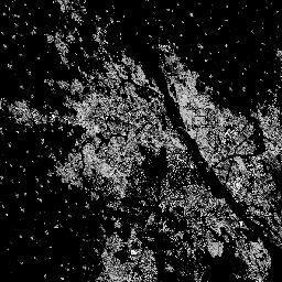
এই রাস্টার ডেটাসেটটি S2 ইমেজ ডেটা থেকে 2018 সালের জন্য বিল্ট-আপ পৃষ্ঠতলের বন্টন, প্রতি 10 মিটার গ্রিড কক্ষে বর্গ মিটারে প্রকাশ করে। ডেটাসেটগুলি পরিমাপ করে: ক) মোট বিল্ট-আপ সারফেস, এবং খ) প্রাধান্য অনাবাসিক (NRES) ব্যবহারের গ্রিড সেলগুলিতে বরাদ্দ করা বিল্ট-আপ পৃষ্ঠ৷ এই…
[null,null,[],[[["\u003cp\u003eThe JRC/GHSL/P2023A/GHS_BUILT_S_10m dataset provides a 10-meter resolution raster depicting the distribution of built-up surfaces for 2018, derived from Sentinel-2 imagery.\u003c/p\u003e\n"],["\u003cp\u003eIt includes two key measurements: total built-up surface area per grid cell and built-up surface classified as predominantly non-residential.\u003c/p\u003e\n"],["\u003cp\u003eThis open and free dataset, produced by the European Commission Joint Research Centre, allows for reuse with proper attribution.\u003c/p\u003e\n"],["\u003cp\u003eThe Global Human Settlement Layer (GHSL) project aims to provide detailed information about human settlements worldwide, supporting various research and policy applications.\u003c/p\u003e\n"],["\u003cp\u003eUsers can access and analyze this dataset within the Google Earth Engine platform for scientific analysis and visualization.\u003c/p\u003e\n"]]],["The dataset from the EC JRC, available from 2018-01-01 to 2019-01-01, provides a 10-meter resolution raster depicting built-up surfaces in square meters per grid cell, derived from Sentinel-2 imagery. It measures total built-up surface area, and the built-up area classified as non-residential. Users can access the data via an Earth Engine snippet and the dataset has been produced by the European Commission Joint Research Centre as open and free data.\n"],null,["# GHSL: Global built-up surface 10m (P2023A)\n\nDataset Availability\n: 2018-01-01T00:00:00Z--2019-01-01T00:00:00Z\n\nDataset Provider\n:\n\n\n [EC JRC](https://ghsl.jrc.ec.europa.eu/ghs_buS2023.php)\n\nTags\n:\n[built](/earth-engine/datasets/tags/built) [built-environment](/earth-engine/datasets/tags/built-environment) [builtup](/earth-engine/datasets/tags/builtup) [copernicus](/earth-engine/datasets/tags/copernicus) [ghsl](/earth-engine/datasets/tags/ghsl) [jrc](/earth-engine/datasets/tags/jrc) [landcover](/earth-engine/datasets/tags/landcover) [population](/earth-engine/datasets/tags/population) [sdg](/earth-engine/datasets/tags/sdg) [sentinel2-derived](/earth-engine/datasets/tags/sentinel2-derived) [settlement](/earth-engine/datasets/tags/settlement) [urban](/earth-engine/datasets/tags/urban) \n\n#### Description\n\nThis raster dataset depicts the distribution of built-up surfaces,\nexpressed in square metres per 10 m grid cell, for 2018\nas observed from the S2 image data.\n\nThe datasets measure:\na) the total built-up surface, and b) the built-up surface allocated to grid\ncells of predominant non-residential (NRES) use.\n\nThe complete information about the GHSL main products can be\nfound in the [GHSL Data Package 2023 report](https://ghsl.jrc.ec.europa.eu/documents/GHSL_Data_Package_2023.pdf?t=1683540422)\n\nThe Global Human Settlement Layer (GHSL) project is supported by the\nEuropean Commission, Joint Research Centre, and Directorate-General for\nRegional and Urban Policy.\n\n### Bands\n\n\n**Pixel Size**\n\n10 meters\n\n**Bands**\n\n| Name | Units | Pixel Size | Description |\n|----------------------|-------|------------|---------------------------------------|\n| `built_surface` | m\\^2 | meters | Built-up surface per grid cell |\n| `built_surface_nres` | | meters | Non-residential built-up class (NRES) |\n\n**built_surface_nres Class Table**\n\n| Value | Color | Description |\n|-------|---------|-------------|\n| 0 | black | non-NRES |\n| 1 | magenta | NRES |\n\n### Terms of Use\n\n**Terms of Use**\n\nThe GHSL has been produced by the European Commission Joint Research Centre\nas open and free data. Reuse is authorised, provided the source is\nacknowledged. For more information, please read the use conditions ([European\nCommission Reuse and Copyright Notice](https://ec.europa.eu/info/legal-notice_en)).\n\n### Citations\n\nCitations:\n\n- Dataset : Pesaresi, Martino; Politis, Panagiotis (2023): GHS-BUILT-S\n R2023A - GHS built-up surface grid, derived from Sentinel2 composite and\n Landsat, multitemporal (1975-2030). European Commission, Joint Research\n Centre (JRC).\n [PID: http://data.europa.eu/89h/9f06f36f-4b11-47ec-abb0-4f8b7b1d72ea](http://data.europa.eu/89h/9f06f36f-4b11-47ec-abb0-4f8b7b1d72ea)\n [doi:10.2905/9F06F36F-4B11-47EC-ABB0-4F8B7B1D72EA](https://doi.org/10.2905/9F06F36F-4B11-47EC-ABB0-4F8B7B1D72EA)\n- Methodology : Pesaresi, Martino, Marcello Schiavina, Panagiotis Politis,\n Sergio Freire, Katarzyna Krasnodebska,\n Johannes H. Uhl, Alessandra Carioli, et al. (2024). Advances on the\n Global Human Settlement Layer by Joint Assessment of Earth Observation\n and Population Survey Data. International Journal of Digital Earth 17(1).\n [doi:10.1080/17538947.2024.2390454](https://doi.org/10.1080/17538947.2024.2390454).\n\n### DOIs\n\n- \u003chttps://doi.org/10.1080/17538947.2024.2390454\u003e\n- \u003chttps://doi.org/10.2905/9F06F36F-4B11-47EC-ABB0-4F8B7B1D72EA\u003e\n\n### Explore with Earth Engine\n\n| **Important:** Earth Engine is a platform for petabyte-scale scientific analysis and visualization of geospatial datasets, both for public benefit and for business and government users. Earth Engine is free to use for research, education, and nonprofit use. To get started, please [register for Earth Engine access.](https://console.cloud.google.com/earth-engine)\n\n### Code Editor (JavaScript)\n\n```javascript\nvar image = ee.Image('JRC/GHSL/P2023A/GHS_BUILT_S_10m/2018');\nvar built_total = image.select('built_surface');\nvar built_nres = image.select('built_surface_nres');\nbuilt_nres = built_nres.updateMask(built_nres.gt(0));\n\nvar visParams = {min: 0.0, max: 100.0, palette: ['000000', 'FFFFFF']};\n\nMap.setCenter(31.23, 30.05, 12);\nMap.addLayer(built_total, visParams, 'Built-up surface [m^2], 2018');\nMap.addLayer(\n built_nres, {palette: ['magenta']},\n 'Non-residential built-up surface, 2018');\n```\n[Open in Code Editor](https://code.earthengine.google.com/?scriptPath=Examples:Datasets/JRC/JRC_GHSL_P2023A_GHS_BUILT_S_10m) \n[GHSL: Global built-up surface 10m (P2023A)](/earth-engine/datasets/catalog/JRC_GHSL_P2023A_GHS_BUILT_S_10m) \nThis raster dataset depicts the distribution of built-up surfaces, expressed in square metres per 10 m grid cell, for 2018 as observed from the S2 image data. The datasets measure: a) the total built-up surface, and b) the built-up surface allocated to grid cells of predominant non-residential (NRES) use. The ... \nJRC/GHSL/P2023A/GHS_BUILT_S_10m, built,built-environment,builtup,copernicus,ghsl,jrc,landcover,population,sdg,sentinel2-derived,settlement,urban \n2018-01-01T00:00:00Z/2019-01-01T00:00:00Z \n-90 -180 90 180 \nGoogle Earth Engine \nhttps://developers.google.com/earth-engine/datasets\n\n- [https://doi.org/10.2905/9F06F36F-4B11-47EC-ABB0-4F8B7B1D72EA](https://doi.org/https://ghsl.jrc.ec.europa.eu/ghs_buS2023.php)\n- [https://doi.org/10.2905/9F06F36F-4B11-47EC-ABB0-4F8B7B1D72EA](https://doi.org/https://developers.google.com/earth-engine/datasets/catalog/JRC_GHSL_P2023A_GHS_BUILT_S_10m)"]]