জিএইচএসএল: নগরায়নের মাত্রা ১৯৭৫-২০৩০ ভি২-০ (পি২০২৩এ) 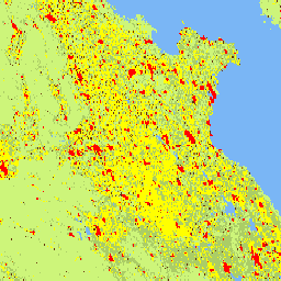
এই রাস্টার ডেটাসেটটি জাতিসংঘের পরিসংখ্যান কমিশন কর্তৃক সুপারিশকৃত "নগরায়নের মাত্রা" প্রথম পর্যায়ের পদ্ধতি প্রয়োগ করে একটি বৈশ্বিক, বহুসাময়িক গ্রামীণ-শহুরে শ্রেণিবিন্যাস উপস্থাপন করে। এটি জিএইচএসএল (GHSL) প্রকল্প দ্বারা ১৯৭৫-২০৩০ সময়কালের জন্য ৫-বছর অন্তর উৎপাদিত বৈশ্বিক গ্রিডযুক্ত জনসংখ্যা এবং নির্মিত পৃষ্ঠের তথ্যের উপর ভিত্তি করে তৈরি। নগরায়নের মাত্রা… জিএইচএসএল জেআরসি জনসংখ্যা এসডিজি বসতি জিএইচএসএল: গ্লোবাল বিল্ডিং হাইট ২০১৮ (পি২০২৩এ) 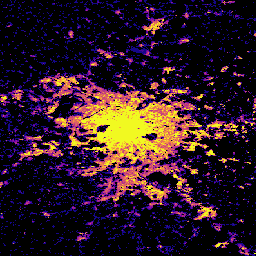
এই স্থানিক রাস্টার ডেটাসেটটি ২০১৮ সালের সাপেক্ষে ১০০ মিটার রেজোলিউশনে ভবনের উচ্চতার বৈশ্বিক বন্টন চিত্রিত করে। ভবনের উচ্চতা পূর্বাভাসের জন্য ব্যবহৃত ইনপুট ডেটাগুলো হলো ALOS গ্লোবাল ডিজিটাল সারফেস মডেল (৩০ মিটার), নাসা শাটল রাডার টপোগ্রাফিক মিশন… এছাড়াও ভবন নির্মিত নির্মিত-পরিবেশ নির্মিত কোপার্নিকাস জিএইচএসএল: বৈশ্বিক ভবন আয়তন ১৯৭৫-২০৩০ (পি২০২৩এ) 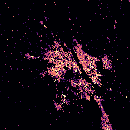
এই রাস্টার ডেটাসেটটি প্রতি ১০০ মিটার গ্রিড সেলে ঘনমিটারে প্রকাশিত ভবনের আয়তনের বৈশ্বিক বন্টন চিত্রিত করে। ডেটাসেটটি মোট ভবনের আয়তন এবং প্রধানত অনাবাসিক (NRES) ব্যবহারের গ্রিড সেলগুলিতে বরাদ্দকৃত ভবনের আয়তন পরিমাপ করে। এই অনুমানগুলি নির্মিত এলাকার উপর ভিত্তি করে করা হয়েছে… alos building built-environment copernicus dem ghsl জিএইচএসএল: গ্লোবাল বিল্ট-আপ সারফেস ১০মি (পি২০২৩এ) 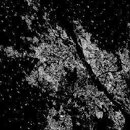
এই রাস্টার ডেটাসেটটি S2 ইমেজ ডেটা থেকে প্রাপ্ত তথ্যের ভিত্তিতে ২০১৮ সালের জন্য নির্মিত পৃষ্ঠের বন্টন চিত্রিত করে, যা প্রতি ১০ মিটার গ্রিড সেলে বর্গমিটারে প্রকাশ করা হয়েছে। ডেটাসেটগুলো পরিমাপ করে: ক) মোট নির্মিত পৃষ্ঠ, এবং খ) … এর গ্রিড সেলগুলোতে বরাদ্দকৃত নির্মিত পৃষ্ঠ। নির্মিত নির্মিত-পরিবেশ নির্মিতআপ কোপারনিকাস জিএইচএসএল জেআরসি জিএইচএসএল: বৈশ্বিক নির্মিত পৃষ্ঠতল ১৯৭৫-২০৩০ (পি২০২৩এ) 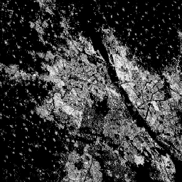
এই রাস্টার ডেটাসেটটি নির্মিত পৃষ্ঠের বন্টন চিত্রিত করে, যা প্রতি ১০০ মিটার গ্রিড সেলে বর্গমিটারে প্রকাশ করা হয়েছে। ডেটাসেটটি পরিমাপ করে: ক) মোট নির্মিত পৃষ্ঠ, এবং খ) প্রধানত অনাবাসিক (NRES) ব্যবহারের গ্রিড সেলগুলিতে বরাদ্দকৃত নির্মিত পৃষ্ঠ। ডেটা স্থানিক-কালিকভাবে ইন্টারপোলেট করা হয়েছে অথবা… নির্মিত নির্মিত-পরিবেশ নির্মিতআপ কোপারনিকাস জিএইচএসএল জেআরসি জিএইচএসএল: বৈশ্বিক জনসংখ্যা পৃষ্ঠ 1975-2030 (পি2023এ) 
এই রাস্টার ডেটাসেটটি আবাসিক জনসংখ্যার স্থানিক বন্টন চিত্রিত করে, যা সেলের বাসিন্দাদের পরম সংখ্যা হিসাবে প্রকাশ করা হয়েছে। CIESIN GPWv4.11 থেকে প্রাপ্ত ১৯৭৫ থেকে ২০২০ সালের মধ্যে ৫-বছর অন্তর আবাসিক জনসংখ্যার অনুমান এবং ২০২৫ ও ২০৩০ সালের প্রক্ষেপণগুলিকে আদমশুমারি বা... থেকে পৃথক করা হয়েছিল। জিএইচএসএল জেআরসি জনসংখ্যা এসডিজি জিএইচএসএল: বৈশ্বিক বসতির বৈশিষ্ট্য (১০ মি) ২০১৮ (পি২০২৩এ) 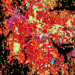
এই স্থানিক রাস্টার ডেটাসেটটি ১০ মিটার রেজোলিউশনে মানব বসতিগুলোকে চিহ্নিত করে এবং নির্মিত পরিবেশের কার্যকরী ও উচ্চতা-সম্পর্কিত উপাদানগুলোর পরিপ্রেক্ষিতে তাদের অভ্যন্তরীণ বৈশিষ্ট্য বর্ণনা করে। GHSL ডেটা প্রোডাক্টগুলো সম্পর্কে আরও তথ্য GHSL ডেটা প্যাকেজ ২০২৩ প্রতিবেদনে পাওয়া যাবে… বিল্ডিং নির্মিত নির্মিত এলাকা কোপারনিকাস জিএইচএসএল উচ্চতা
Datasets tagged sdg in Earth Engine
[null,null,[],[],[]]