- در دسترس بودن مجموعه دادهها
- 1984-03-16T00:00:00Z–2020-01-01T00:00:00Z
- تولیدکننده مجموعه داده
- کمیسیون تحقیقات عدالت اروپا / گوگل
- برچسبها
توضیحات
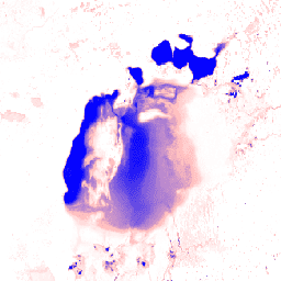
این مجموعه دادهها شامل نقشههایی از موقعیت مکانی و توزیع زمانی آبهای سطحی از سال ۱۹۸۴ تا ۲۰۱۹ است و آماری در مورد میزان و تغییر آن سطوح آب ارائه میدهد. برای اطلاعات بیشتر به مقاله مرتبط در مجله: نقشهبرداری با وضوح بالا از آبهای سطحی جهانی و تغییرات بلندمدت آن (نیچر، ۲۰۱۶) و راهنمای آنلاین کاربران داده مراجعه کنید.
این دادهها با استفاده از ۴,۱۸۵,۴۳۹ صحنه از لندست ۵، ۷ و ۸ که بین ۱۶ مارس ۱۹۸۴ و ۳۱ دسامبر ۲۰۱۹ به دست آمدهاند، تولید شدهاند. هر پیکسل به صورت جداگانه با استفاده از یک سیستم خبره به آب/غیرآب طبقهبندی شد و نتایج برای کل دوره زمانی و دو دوره (۱۹۸۴-۱۹۹۹، ۲۰۰۰-۲۰۱۹) برای تشخیص تغییرات، در یک تاریخچه ماهانه گردآوری شدند.
این محصول لایههای نقشهبرداری شامل ۱ تصویر حاوی ۷ باند است. این تصویر جنبههای مختلف توزیع مکانی و زمانی آبهای سطحی را در طول ۳۵ سال گذشته نقشهبرداری میکند. مناطقی که هرگز آب در آنها شناسایی نشده است، پنهان شدهاند.
باندها
باندها
اندازه پیکسل: 30 متر (همه باندها)
| نام | واحدها | حداقل | مکس | اندازه پیکسل | توضیحات | ||||||||||||||||||||||||||||||||||||||||||||||||||||||||||||||||||||||||||||||||||||||||||||||
|---|---|---|---|---|---|---|---|---|---|---|---|---|---|---|---|---|---|---|---|---|---|---|---|---|---|---|---|---|---|---|---|---|---|---|---|---|---|---|---|---|---|---|---|---|---|---|---|---|---|---|---|---|---|---|---|---|---|---|---|---|---|---|---|---|---|---|---|---|---|---|---|---|---|---|---|---|---|---|---|---|---|---|---|---|---|---|---|---|---|---|---|---|---|---|---|---|---|---|---|
occurrence | % | 0 | ۱۰۰ | ۳۰ متر | فراوانی حضور آب. | ||||||||||||||||||||||||||||||||||||||||||||||||||||||||||||||||||||||||||||||||||||||||||||||
change_abs | % | -100 | ۱۰۰ | ۳۰ متر | تغییر مطلق در وقوع بین دو دوره: ۱۹۸۴-۱۹۹۹ در مقابل ۲۰۰۰-۲۰۱۹. | ||||||||||||||||||||||||||||||||||||||||||||||||||||||||||||||||||||||||||||||||||||||||||||||
change_norm | % | -100 | ۱۰۰ | ۳۰ متر | تغییر نرمالشده در وقوع. (epoch1-epoch2)/(epoch1+epoch2) * 100 | ||||||||||||||||||||||||||||||||||||||||||||||||||||||||||||||||||||||||||||||||||||||||||||||
seasonality | 0 | ۱۲ | ۳۰ متر | تعداد ماههایی که آب وجود دارد. | |||||||||||||||||||||||||||||||||||||||||||||||||||||||||||||||||||||||||||||||||||||||||||||||
recurrence | % | 0 | ۱۰۰ | ۳۰ متر | فراوانی بازگشت آب از سالی به سال دیگر. | ||||||||||||||||||||||||||||||||||||||||||||||||||||||||||||||||||||||||||||||||||||||||||||||
transition | ۳۰ متر | طبقهبندی قطعی تغییرات بین سال اول و سال آخر. | |||||||||||||||||||||||||||||||||||||||||||||||||||||||||||||||||||||||||||||||||||||||||||||||||
max_extent | ۳۰ متر | تصویر دودویی حاوی ۱ در هر جایی که تا به حال آب شناسایی شده است. | |||||||||||||||||||||||||||||||||||||||||||||||||||||||||||||||||||||||||||||||||||||||||||||||||
جدول کلاس انتقال
| ارزش | رنگ | توضیحات |
|---|---|---|
| 0 | #فففف | بدون تغییر |
| ۱ | #۰۰۰۰ff | دائمی |
| ۲ | #۲۲b14c | دائمی جدید |
| ۳ | #d1102d | گم شدن دائمی |
| ۴ | #۹۹d9ea | فصلی |
| ۵ | #b5e61d | فصلی جدید |
| ۶ | #e6a1aa | فصلی از دست رفته |
| ۷ | #ff7f27 | فصلی تا دائمی |
| ۸ | #ffc90e | دائمی تا فصلی |
| ۹ | #7f7f7f | زودگذر دائمی |
| ۱۰ | #c3c3c3 | فصلی زودگذر |
شرایط استفاده
شرایط استفاده
تمام دادههای اینجا تحت برنامه کوپرنیک تولید شده و به صورت رایگان و بدون محدودیت در استفاده ارائه میشود. برای اطلاعات کامل مجوز، به آییننامه کوپرنیک مراجعه کنید.
انتشارات، مدلها و محصولات دادهای که از این مجموعه دادهها استفاده میکنند باید شامل تقدیرنامه مناسب، از جمله استناد به مجموعه دادهها و مقاله مجله، مانند آنچه در ادامه میآید، باشند.
اگر از دادهها به عنوان لایهای در یک نقشه منتشر شده استفاده میکنید، لطفاً متن ارجاع زیر را ذکر کنید: «منبع: EC JRC/Google»
نقل قولها
ژان فرانسوا پکل، اندرو کاتم، نوئل گورلیک، آلن اس. بلورد، نقشهبرداری با وضوح بالا از آبهای سطحی جهان و تغییرات بلندمدت آن. نیچر ۵۴۰، ۴۱۸-۴۲۲ (۲۰۱۶). ( doi:10.1038/nature20584 )
با موتور زمین کاوش کنید
ویرایشگر کد (جاوااسکریپت)
var dataset = ee.Image('JRC/GSW1_2/GlobalSurfaceWater');

var visualization = {
  bands: ['occurrence'],
  min: 0.0,
  max: 100.0,
  palette: ['ffffff', 'ffbbbb', '0000ff']
};

Map.setCenter(59.414, 45.182, 6);

Map.addLayer(dataset, visualization, 'Occurrence');