- در دسترس بودن مجموعه دادهها
- 1984-03-16T00:00:00Z–2022-01-01T00:00:00Z
- تولیدکننده مجموعه داده
- کمیسیون تحقیقات عدالت اروپا / گوگل
- کادانس
- ۱ ماه
- برچسبها
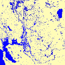
توضیحات
این مجموعه دادهها شامل نقشههایی از موقعیت مکانی و توزیع زمانی آبهای سطحی از سال ۱۹۸۴ تا ۲۰۲۱ است و آماری در مورد میزان و تغییر این سطوح آب ارائه میدهد. برای اطلاعات بیشتر به مقاله مرتبط در مجله: نقشهبرداری با وضوح بالا از آبهای سطحی جهانی و تغییرات بلندمدت آن (نیچر، ۲۰۱۶) و راهنمای آنلاین کاربران داده مراجعه کنید.
این دادهها با استفاده از ۴,۷۱۶,۴۷۵ صحنه از لندست ۵، ۷ و ۸ که بین ۱۶ مارس ۱۹۸۴ و ۳۱ دسامبر ۲۰۲۱ به دست آمدهاند، تولید شدهاند. هر پیکسل به صورت جداگانه با استفاده از یک سیستم خبره به آب/غیرآب طبقهبندی شد و نتایج برای تشخیص تغییرات در یک تاریخچه ماهانه برای کل دوره زمانی و دو دوره (۱۹۸۴-۱۹۹۹، ۲۰۰۰-۲۰۲۱) گردآوری شد.
این مجموعه تاریخچه ماهانه، کل تاریخچه تشخیص آب را به صورت ماه به ماه در خود جای داده است. این مجموعه شامل ۴۵۴ تصویر است، یکی برای هر ماه بین مارس ۱۹۸۴ و دسامبر ۲۰۲۱.
باندها
باندها
اندازه پیکسل: 30 متر (همه باندها)
| نام | اندازه پیکسل | توضیحات | |||||||||||||||||||||||||||||||||||||||||||||||||||||||||||||||||||||||||||||||||||||||||||||||||
|---|---|---|---|---|---|---|---|---|---|---|---|---|---|---|---|---|---|---|---|---|---|---|---|---|---|---|---|---|---|---|---|---|---|---|---|---|---|---|---|---|---|---|---|---|---|---|---|---|---|---|---|---|---|---|---|---|---|---|---|---|---|---|---|---|---|---|---|---|---|---|---|---|---|---|---|---|---|---|---|---|---|---|---|---|---|---|---|---|---|---|---|---|---|---|---|---|---|---|---|
water | ۳۰ متر | تشخیص آب برای ماه. | |||||||||||||||||||||||||||||||||||||||||||||||||||||||||||||||||||||||||||||||||||||||||||||||||
ویژگیهای تصویر
ویژگیهای تصویر
| نام | نوع | توضیحات |
|---|---|---|
| ماه | دو برابر | ماه |
| سال | دو برابر | سال |
شرایط استفاده
شرایط استفاده
تمام دادههای اینجا تحت برنامه کوپرنیک تولید شده و به صورت رایگان و بدون محدودیت در استفاده ارائه میشود. برای اطلاعات کامل مجوز، به آییننامه کوپرنیک مراجعه کنید.
انتشارات، مدلها و محصولات دادهای که از این مجموعه دادهها استفاده میکنند باید شامل تقدیرنامه مناسب، از جمله استناد به مجموعه دادهها و مقاله مجله، مانند آنچه در ادامه میآید، باشند.
اگر از دادهها به عنوان لایهای در یک نقشه منتشر شده استفاده میکنید، لطفاً متن ارجاع زیر را ذکر کنید: «منبع: EC JRC/Google»
نقل قولها
ژان فرانسوا پکل، اندرو کاتم، نوئل گورلیک، آلن اس. بلورد، نقشهبرداری با وضوح بالا از آبهای سطحی جهان و تغییرات بلندمدت آن. نیچر ۵۴۰، ۴۱۸-۴۲۲ (۲۰۱۶). ( doi:10.1038/nature20584 )
با موتور زمین کاوش کنید
ویرایشگر کد (جاوااسکریپت)
var dataset = ee.Image('JRC/GSW1_4/MonthlyHistory/2020_06');

var visualization = {
  bands: ['water'],
  min: 0.0,
  max: 2.0,
  palette: ['ffffff', 'fffcb8', '0905ff']
};

Map.setCenter(-121.234, 38.109, 7);

Map.addLayer(dataset, visualization, 'Water');