Dane te zostały wygenerowane na podstawie 4 716 475 scen z satelitów Landsat 5, 7 i 8, które zostały zarejestrowane między 16 marca 1984 r. a 31 grudnia 2021 r.
Każdy piksel został indywidualnie sklasyfikowany jako woda lub nie-woda za pomocą systemu eksperckiego, a wyniki zostały zestawione w miesięczną historię dla całego okresu i dwóch epok (1984–1999, 2000–2021) na potrzeby wykrywania zmian.
Kolekcja „Monthly Recurrence” zawiera 12 obrazów: miesięczne pomiary sezonowości wody na podstawie wartości występowania wykrytych w danym miesiącu we wszystkich latach.
Pasma
Rozmiar piksela 30 metrów
Pasma
Nazwa
Jednostki
Minimum
Maks.
Rozmiar piksela
Opis
monthly_recurrence
%
0
100
metry
Wartość powtarzalności wyrażona w procentach w tym miesiącu.
has_observations
metry
Flaga wskazująca, czy w danym miesiącu były obserwacje.
Bitmaska dla has_observations
Bit 0: obserwacje z danego miesiąca.
0. Brak prawidłowych obserwacji
1. Dostępna była co najmniej 1 prawidłowa obserwacja.
Właściwości obrazu
Właściwości obrazu
Nazwa
Typ
Opis
miesiąc
LICZBA ZMIENNOPRZECINKOWA O PODWÓJNEJ PRECYZJI
Miesiąc
Warunki korzystania z usługi
Wszystkie dane są tworzone w ramach programu Copernicus i udostępniane bezpłatnie, bez ograniczeń dotyczących ich wykorzystania. Pełne informacje o licencji znajdziesz w rozporządzeniu Copernicus.
Publikacje, modele i usługi danych, które korzystają z tych zbiorów danych, muszą zawierać odpowiednie podziękowania, w tym cytowanie zbiorów danych i artykułu w czasopiśmie, jak w tym przykładzie:
Jeśli używasz danych jako warstwy na opublikowanej mapie, podaj ten tekst z atrybucją: „Źródło: EC JRC/Google”.
Cytaty
Cytowania:
Jean-Francois Pekel, Andrew Cottam, Noel Gorelick, Alan S. Belward, High-resolution mapping of global surface water and its long-term changes (Mapowanie w wysokiej rozdzielczości globalnych wód powierzchniowych i ich długoterminowych zmian).
Nature 540, 418-422 (2016). (doi:10.1038/nature20584)
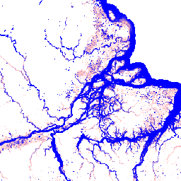
Ten zbiór danych zawiera mapy lokalizacji i rozmieszczenia w czasie wód powierzchniowych w latach 1984–2021 oraz statystyki dotyczące zasięgu i zmian tych wód. Więcej informacji znajdziesz w powiązanym artykule w czasopiśmie: High-resolution mapping of global surface water and its long-term changes (Nature, 2016) i …
[null,null,[],[[["\u003cp\u003eThis dataset provides monthly maps of surface water occurrence from 1984 to 2021, derived from Landsat 5, 7, and 8 imagery.\u003c/p\u003e\n"],["\u003cp\u003eIt offers insights into the location, distribution, and changes in global surface water over time.\u003c/p\u003e\n"],["\u003cp\u003eThe dataset includes monthly recurrence data, indicating the percentage of time water was present in each location for a given month.\u003c/p\u003e\n"],["\u003cp\u003eData is freely available for use with proper attribution to EC JRC/Google and citation of the associated journal article.\u003c/p\u003e\n"],["\u003cp\u003eUsers can explore and analyze this dataset using Google Earth Engine.\u003c/p\u003e\n"]]],["This dataset, provided by EC JRC/Google, maps global surface water distribution and changes from March 1984 to December 2021. Derived from over 4.7 million Landsat scenes, each pixel is classified as water or non-water. The data is compiled into a monthly history and two epochs (1984-1999, 2000-2021) for change analysis. The monthly recurrence collection contains data on water seasonality and whether a month has observations, with a pixel size of 30 meters.\n"],null,["# JRC Monthly Water Recurrence, v1.4\n\nDataset Availability\n: 1984-03-16T00:00:00Z--2022-01-01T00:00:00Z\n\nDataset Provider\n:\n\n\n [EC JRC / Google](https://global-surface-water.appspot.com)\n\nClimatological Interval\n: 1 Month\n\nTags\n:\n [geophysical](/earth-engine/datasets/tags/geophysical) [google](/earth-engine/datasets/tags/google) [history](/earth-engine/datasets/tags/history) [jrc](/earth-engine/datasets/tags/jrc) [landsat-derived](/earth-engine/datasets/tags/landsat-derived) [monthly](/earth-engine/datasets/tags/monthly) [surface](/earth-engine/datasets/tags/surface) [surface-ground-water](/earth-engine/datasets/tags/surface-ground-water) [water](/earth-engine/datasets/tags/water) \nrecurrence \n\n#### Description\n\nThis dataset contains maps of the location and temporal\ndistribution of surface water from 1984 to 2021 and provides\nstatistics on the extent and change of those water surfaces.\nFor more information see the associated journal article: [High-resolution\nmapping of global surface water and its long-term changes](https://www.nature.com/nature/journal/v540/n7633/full/nature20584.html)\n(Nature, 2016) and the online\n[Data Users Guide](https://storage.googleapis.com/global-surface-water/downloads_ancillary/DataUsersGuidev2021.pdf).\n\nThese data were generated using 4,716,475 scenes from Landsat\n5, 7, and 8 acquired between 16 March 1984 and 31 December 2021.\nEach pixel was individually classified into water / non-water\nusing an expert system and the results were collated into a monthly\nhistory for the entire time period and two epochs (1984-1999,\n2000-2021) for change detection.\n\nThe Monthly Recurrence collection contains 12 images: monthly measures of\nthe seasonality of water based on the occurrence values detected in that\nmonth over all years.\n\n### Bands\n\n\n**Pixel Size**\n\n30 meters\n\n**Bands**\n\n| Name | Units | Min | Max | Pixel Size | Description |\n|----------------------|-------|-----|-----|------------|----------------------------------------------------------------|---|---|---|---|---|---|---|---|---|---|---|---|---|---|---|---|---|---|---|---|---|---|---|---|---|---|---|---|---|---|---|---|---|---|---|---|---|---|---|---|---|---|---|---|---|---|---|---|---|---|---|---|---|---|---|---|---|---|---|---|---|---|---|---|---|---|---|---|---|---|---|---|---|---|---|---|---|---|---|---|---|---|---|---|---|---|---|---|---|---|---|---|---|---|\n| `monthly_recurrence` | % | 0 | 100 | meters | The recurrence value expressed as a percentage for this month. |\n| `has_observations` | | | | meters | A flag to indicate if the month has observations. |\n| Bitmask for has_observations - Bit 0: Observations for the month. - 0: No valid observations - 1: At least 1 valid observation was available ||||||||||||||||||||||||||||||||||||||||||||||||||||||||||||||||||||||||||||||||||||||||||||||||||||\n\n### Image Properties\n\n**Image Properties**\n\n| Name | Type | Description |\n|-------|--------|-------------|\n| month | DOUBLE | Month |\n\n### Terms of Use\n\n**Terms of Use**\n\nAll data here is produced under the Copernicus Programme and is provided\nfree of charge, without restriction of use. For the full license\ninformation see the Copernicus Regulation.\n\nPublications, models, and data products that make use of these datasets\nmust include proper acknowledgement, including citing datasets and the\njournal article as in the following citation.\n\nIf you are using the data as a layer in a published map, please include the\nfollowing attribution text: 'Source: EC JRC/Google'\n\n### Citations\n\nCitations:\n\n- Jean-Francois Pekel, Andrew Cottam, Noel Gorelick, Alan S. Belward,\n High-resolution mapping of global surface water and its long-term changes.\n Nature 540, 418-422 (2016). ([doi:10.1038/nature20584](https://doi.org/10.1038/nature20584))\n\n### Explore with Earth Engine\n\n| **Important:** Earth Engine is a platform for petabyte-scale scientific analysis and visualization of geospatial datasets, both for public benefit and for business and government users. Earth Engine is free to use for research, education, and nonprofit use. To get started, please [register for Earth Engine access.](https://console.cloud.google.com/earth-engine)\n\n### Code Editor (JavaScript)\n\n```javascript\nvar dataset = ee.ImageCollection('JRC/GSW1_4/MonthlyRecurrence');\n\nvar visualization = {\n bands: ['monthly_recurrence'],\n min: 0.0,\n max: 100.0,\n palette: ['ffffff', 'ffbbbb', '0000ff']\n};\n\nMap.setCenter(-51.482, -0.835, 6);\n\nMap.addLayer(dataset, visualization, 'Monthly Recurrence');\n```\n[Open in Code Editor](https://code.earthengine.google.com/?scriptPath=Examples:Datasets/JRC/JRC_GSW1_4_MonthlyRecurrence) \n[JRC Monthly Water Recurrence, v1.4](/earth-engine/datasets/catalog/JRC_GSW1_4_MonthlyRecurrence) \nThis dataset contains maps of the location and temporal distribution of surface water from 1984 to 2021 and provides statistics on the extent and change of those water surfaces. For more information see the associated journal article: High-resolution mapping of global surface water and its long-term changes (Nature, 2016) and ... \nJRC/GSW1_4/MonthlyRecurrence, geophysical,google,history,jrc,landsat-derived,monthly,surface,surface-ground-water,water \n1984-03-16T00:00:00Z/2022-01-01T00:00:00Z \n-90 -180 90 180 \nGoogle Earth Engine \nhttps://developers.google.com/earth-engine/datasets\n\n- [](https://doi.org/https://global-surface-water.appspot.com)\n- [](https://doi.org/https://developers.google.com/earth-engine/datasets/catalog/JRC_GSW1_4_MonthlyRecurrence)"]]