- 数据集可用时间
- 2000-02-18T00:00:00Z–2026-07-12T00:00:00Z
- 数据集生产者
- 美国地质调查局地球资源观测与科学中心下属的美国国家航空航天局陆地过程分布式主动存档中心
- 频率
- 8 天
- 标签
说明
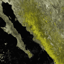
MOD09Q1 产品提供 250 米分辨率下波段 1 和 2 的地表光谱反射率估计值,并针对气体、气溶胶和瑞利散射等大气条件进行了校正。除了这两个反射率波段,还包括一个质量层。对于每个像素,系统会根据高观测覆盖率、低视角、无云或云影以及低气溶胶负荷等条件,从 8 天合成期内的所有采集中选择一个值。
文档:
频段
波段
像素大小:250 米(所有波段)
| 名称 | 最小值 | 最大值 | 缩放系数 | 像元大小 | 波长 | 说明 | |||||||||||||||||||||||||||||||||||||||||||||||||||||||||||||||||||||||||||||||||||||||||||||
|---|---|---|---|---|---|---|---|---|---|---|---|---|---|---|---|---|---|---|---|---|---|---|---|---|---|---|---|---|---|---|---|---|---|---|---|---|---|---|---|---|---|---|---|---|---|---|---|---|---|---|---|---|---|---|---|---|---|---|---|---|---|---|---|---|---|---|---|---|---|---|---|---|---|---|---|---|---|---|---|---|---|---|---|---|---|---|---|---|---|---|---|---|---|---|---|---|---|---|---|
sur_refl_b01 |
-100 | 16000 | 0.0001 | 250 米 | 620-670nm | 地表反射率波段 1 |
|||||||||||||||||||||||||||||||||||||||||||||||||||||||||||||||||||||||||||||||||||||||||||||
sur_refl_b02 |
-100 | 16000 | 0.0001 | 250 米 | 841-876nm | 波段 2 的地表反射率 |
|||||||||||||||||||||||||||||||||||||||||||||||||||||||||||||||||||||||||||||||||||||||||||||
State |
250 米 | 无 | 地表反射率 250 米状态标志 |
||||||||||||||||||||||||||||||||||||||||||||||||||||||||||||||||||||||||||||||||||||||||||||||||
QA |
250 米 | 无 | 地表反射率 250 米波段质量控制标志 |
||||||||||||||||||||||||||||||||||||||||||||||||||||||||||||||||||||||||||||||||||||||||||||||||
使用条款
使用条款
通过 LP DAAC 获取的 MODIS 数据和产品在后续使用、销售或再分发方面没有任何限制。
引用
引用:
如需了解如何引用 LP DAAC 数据集,请访问 LP DAAC 的“引用我们的数据”页面。
DOI
通过 Earth Engine 探索
代码编辑器 (JavaScript)
var dataset = ee.ImageCollection('MODIS/061/MOD09Q1')
                  .filter(ee.Filter.date('2018-01-01', '2018-05-01'));
var falseColorVis = {
  min: -100.0,
  max: 8000.0,
  bands: ['sur_refl_b02', 'sur_refl_b02', 'sur_refl_b01'],
};
Map.setCenter(6.746, 46.529, 2);
Map.addLayer(dataset, falseColorVis, 'False Color');