Page Summary
-
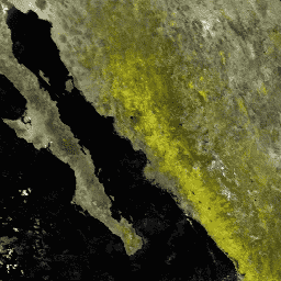
The MOD09Q1 product provides an estimate of the surface spectral reflectance of bands 1 and 2 at 250m resolution, corrected for atmospheric conditions.
-
This dataset is available from 2000-02-18 to 2025-10-08 with an 8-day cadence.
-
The product includes surface reflectance bands and quality layers selected based on factors like observation coverage, view angle, cloud absence, and aerosol loading.
-
MODIS data and products acquired through the LP DAAC have no restrictions on subsequent use, sale, or redistribution.
- Dataset Availability
- 2000-02-18T00:00:00Z–2026-04-15T00:00:00Z
- Dataset Producer
- NASA LP DAAC at the USGS EROS Center
- Cadence
- 8 Days
- Tags
Description
The MOD09Q1 product provides an estimate of the surface spectral reflectance of bands 1 and 2 at 250m resolution and corrected for atmospheric conditions such as gasses, aerosols, and Rayleigh scattering. Along with the two reflectance bands, a quality layer is also included. For each pixel, a value is selected from all the acquisitions within the 8-day composite on the basis of high observation coverage, low view angle, the absence of clouds or cloud shadow, and aerosol loading.
Documentation:
Bands
Bands
Pixel size: 250 meters (all bands)
| Name | Min | Max | Scale | Pixel Size | Wavelength | Description | |||||||||||||||||||||||||||||||||||||||||||||||||||||||||||||||||||||||||||||||||||||||||||||
|---|---|---|---|---|---|---|---|---|---|---|---|---|---|---|---|---|---|---|---|---|---|---|---|---|---|---|---|---|---|---|---|---|---|---|---|---|---|---|---|---|---|---|---|---|---|---|---|---|---|---|---|---|---|---|---|---|---|---|---|---|---|---|---|---|---|---|---|---|---|---|---|---|---|---|---|---|---|---|---|---|---|---|---|---|---|---|---|---|---|---|---|---|---|---|---|---|---|---|---|
sur_refl_b01 |
-100 | 16000 | 0.0001 | 250 meters | 620-670nm | Surface reflectance band 1 |
|||||||||||||||||||||||||||||||||||||||||||||||||||||||||||||||||||||||||||||||||||||||||||||
sur_refl_b02 |
-100 | 16000 | 0.0001 | 250 meters | 841-876nm | Surface reflectance for band 2 |
|||||||||||||||||||||||||||||||||||||||||||||||||||||||||||||||||||||||||||||||||||||||||||||
State |
250 meters | None | Surface reflectance 250m state flags |
||||||||||||||||||||||||||||||||||||||||||||||||||||||||||||||||||||||||||||||||||||||||||||||||
QA |
250 meters | None | Surface reflectance 250m band quality control flags |
||||||||||||||||||||||||||||||||||||||||||||||||||||||||||||||||||||||||||||||||||||||||||||||||
Terms of Use
Terms of Use
MODIS data and products acquired through the LP DAAC have no restrictions on subsequent use, sale, or redistribution.
Citations
Please visit LP DAAC 'Citing Our Data' page for information on citing LP DAAC datasets.
DOIs
Explore with Earth Engine
Code Editor (JavaScript)
var dataset = ee.ImageCollection('MODIS/061/MOD09Q1')
                  .filter(ee.Filter.date('2018-01-01', '2018-05-01'));
var falseColorVis = {
  min: -100.0,
  max: 8000.0,
  bands: ['sur_refl_b02', 'sur_refl_b02', 'sur_refl_b01'],
};
Map.setCenter(6.746, 46.529, 2);
Map.addLayer(dataset, falseColorVis, 'False Color');