Page Summary
-
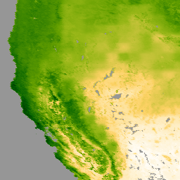
The Terra Moderate Resolution Imaging Spectroradiometer (MODIS) MOD16A2GF Version 6.1 dataset provides year-end gap-filled 8-day composite Evapotranspiration/Latent Heat Flux data at 500-meter pixel resolution from 2000 to the present.
-
This product is based on the Penman-Monteith equation, using daily meteorological reanalysis and MODIS data.
-
The dataset includes bands for Evapotranspiration (ET), Latent Heat Flux (LE), Potential Evapotranspiration (PET), Potential Latent Heat Flux (PLE), and an Evapotranspiration quality control flag (ET_QC).
-
MODIS data acquired through the LP DAAC have no restrictions on subsequent use, sale, or redistribution.
- Dataset Availability
- 2000-01-01T00:00:00Z–2025-12-27T00:00:00Z
- Dataset Producer
- NASA LP DAAC at the USGS EROS Center
- Cadence
- 8 Days
- Tags
Description
The Terra Moderate Resolution Imaging Spectroradiometer (MODIS) MOD16A2GF Version 6.1 Evapotranspiration/Latent Heat Flux (ET/LE) product is a year-end gap-filled 8-day composite dataset produced at 500 meter (m) pixel resolution. The algorithm used for the MOD16 data product collection is based on the logic of the Penman-Monteith equation, which includes inputs of daily meteorological reanalysis data along with MODIS remotely sensed data products such as vegetation property dynamics, albedo, and land cover.
The pixel values for the two Evapotranspiration layers (ET and PET) are the sum of all eight days within the composite period, and the pixel values for the two Latent Heat layers (LE and PLE) are the average of all eight days within the composite period. The last acquisition period of each year is a 5 or 6-day composite period, depending on the year.
Documentation:
Bands
Bands
Pixel size: 500 meters (all bands)
| Name | Units | Min | Max | Scale | Pixel Size | Description | |||||||||||||||||||||||||||||||||||||||||||||||||||||||||||||||||||||||||||||||||||||||||||||
|---|---|---|---|---|---|---|---|---|---|---|---|---|---|---|---|---|---|---|---|---|---|---|---|---|---|---|---|---|---|---|---|---|---|---|---|---|---|---|---|---|---|---|---|---|---|---|---|---|---|---|---|---|---|---|---|---|---|---|---|---|---|---|---|---|---|---|---|---|---|---|---|---|---|---|---|---|---|---|---|---|---|---|---|---|---|---|---|---|---|---|---|---|---|---|---|---|---|---|---|
ET |
kg/m^2/8day | -32767 | 32700 | 0.1 | 500 meters | Total evapotranspiration |
|||||||||||||||||||||||||||||||||||||||||||||||||||||||||||||||||||||||||||||||||||||||||||||
LE |
J/m^2/day | -32767 | 32700 | 10000 | 500 meters | Average latent heat flux |
|||||||||||||||||||||||||||||||||||||||||||||||||||||||||||||||||||||||||||||||||||||||||||||
PET |
kg/m^2/8day | -32767 | 32700 | 0.1 | 500 meters | Total potential evapotranspiration |
|||||||||||||||||||||||||||||||||||||||||||||||||||||||||||||||||||||||||||||||||||||||||||||
PLE |
J/m^2/day | -32767 | 32700 | 10000 | 500 meters | Average potential latent heat flux |
|||||||||||||||||||||||||||||||||||||||||||||||||||||||||||||||||||||||||||||||||||||||||||||
ET_QC |
500 meters | Evapotranspiration quality control flags |
|||||||||||||||||||||||||||||||||||||||||||||||||||||||||||||||||||||||||||||||||||||||||||||||||
Terms of Use
Terms of Use
MODIS data and products acquired through the LP DAAC have no restrictions on subsequent use, sale, or redistribution.
Citations
Please visit LP DAAC 'Citing Our Data' page for information on citing LP DAAC datasets.
DOIs
Explore with Earth Engine
Code Editor (JavaScript)
var dataset = ee.ImageCollection('MODIS/061/MOD16A2GF')
                  .filter(ee.Filter.date('2022-01-01', '2022-05-01'));
var evapotranspiration = dataset.select('ET');
var evapotranspirationVis = {
  min: 0,
  max: 300,
  palette: [
    'ffffff', 'fcd163', '99b718', '66a000', '3e8601', '207401', '056201',
    '004c00', '011301'
  ],
};
Map.setCenter(0, 0, 2);
Map.addLayer(evapotranspiration, evapotranspirationVis, 'Evapotranspiration');