- توفّر مجموعة البيانات
- 2012-06-03T00:00:00Z–2020-09-03T23:59:59Z
- مزوّد مجموعة البيانات
- جامعة مينيسوتا، مركز القطبين الجغرافي المكاني
- العلامات
الوصف
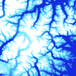
ArcticDEM هي مبادرة مشتركة بين القطاعَين العام والخاص أطلقتها "الوكالة الوطنية للاستخبارات الجغرافية المكانية" (NGA) و"مؤسسة العلوم الوطنية" (NSF) بهدف إنتاج نموذج رقمي لسطح الأرض (DSM) عالي الدقة والجودة في القطب الشمالي تلقائيًا باستخدام صور مجسمة بصرية وحوسبة عالية الأداء وبرامج قياس التصوير مفتوحة المصدر. ويشمل ذلك الغطاء النباتي وأغصان الأشجار والمباني وغيرها من الميزات السطحية التي من صنع الإنسان. تتألف مادة العرض التي تبلغ دقتها مترَين من مجموعة من الشرائط بدلاً من فسيفساء واحدة بسبب الاختلافات في العرض بين الشرائط.
يتم تجميع ملفات DEM الموزّعة من أفضل ملفات DEM ذات الجودة العالية، والتي تم دمجها وتنعيمها لتقليل المساحات الفارغة والتشوهات الناتجة عن مطابقة الحواف. تم تطبيق بيانات قياس الارتفاعات المصفّاة من IceSAT على ملفات الصور النقطية لتحسين الدقة المطلقة.
تتضمّن فسيفساء الإصدار (V4.1) نطاقات نقطية إضافية، وهي: count وmad وmindate وmaxdate، وذلك لتوفير معلومات حول مصدر البيانات ومدى صحتها.
النطاقات
حجم البكسل
متران
النطاقات
| الاسم | الوحدات | الحد الأدنى | الحد الأقصى | حجم البكسل | الوصف |
|---|---|---|---|---|---|
elevation |
م | -416.45* | 5971.24* | أمتار | الارتفاع |
count |
أمتار | عدد نماذج الارتفاع الرقمية المصدرية المستخدَمة لاحتساب قيمة الارتفاع عند تلك البكسل |
|||
mad |
م | أمتار | متوسط الانحراف المطلق لمجموعة بيانات المصدر عن قيمة الارتفاع المتوسطة |
||
mindate |
أمتار | أقدم تاريخ لبيانات DEM المصدر المستخدَمة لإنشاء الفسيفساء، ويتم التعبير عنه بعدد الأيام منذ 1 يناير 2000. |
|||
maxdate |
أمتار | أحدث تاريخ لبيانات DEM المصدر المستخدَمة لإنشاء الفسيفساء، ويتم التعبير عنه بعدد الأيام منذ 1 كانون الثاني (يناير) 2000. |
|||
datamask |
أمتار | يشير قناع البيانات إلى ما إذا كان الارتفاع 0 أو 1، حيث يشير 0 إلى أنّه تم ملء البيانات أو دمجها مع مجموعة بيانات أخرى أو إخفاؤها كـ NoData في خطوات مراقبة الجودة. يشير الرقم 1 إلى الناتج الذي تم الحصول عليه باستخدام SETSM، وهو حزمة برامج من جامعة ولاية أوهايو لتقليل مساحة البحث المستندة إلى TIN لاستخراج الأسطح. |
بنود الاستخدام
بنود الاستخدام
تتطلّب سياسة "المؤسسة الوطنية للعلوم" (مصدر التمويل الأساسي لـ PGC) من الباحثين الإشارة إلى الدعم الذي تقدّمه المؤسسة في جميع المنشورات وصفحات الويب والمقابلات الإعلامية.
باستخدام بيانات PGC في Earth Engine، يوافق المستخدمون على الإشارة إلى PGC ورعايتها من قِبل مؤسسة NSF. يجب أيضًا الإشارة بشكل صحيح إلى المصدر الأصلي لأي بيانات تابعة لجهة خارجية تقدّمها "محتوى من إنشاء المستخدمين".
لمزيد من المعلومات، يُرجى الاطّلاع على سياسة الإقرار الخاصة بـ PGC.
الاقتباسات
نماذج الارتفاع الرقمية التي أنشأها "مركز Polar Geospatial Center" من صور DigitalGlobe, Inc. Porter, Claire; Morin, Paul; Howat, Ian; Noh, Myoung-Jon; Bates, Brian; Peterman, Kenneth; Keesey, Scott; Schlenk, Matthew; Gardiner, Judith; Tomko, Karen; Willis, Michael; Kelleher, Cole; Cloutier, Michael; Husby, Eric; Foga, Steven; Nakamura, Hitomi; Platson, Melisa; Wethington, Michael, Jr.; Williamson, Cathleen; Bauer, Gregory; Enos, Jeremy; Arnold, Galen; Kramer, William; Becker, Peter; Doshi, Abhijit; D'Souza, Cristelle; Cummens, Pat; Laurier, Fabien; Bojesen, Mikkel, 2018, ArcticDEM, Harvard Dataverse, V1, [Date Accessed].
معرّفات العناصر الرقمية
الاستكشاف باستخدام Earth Engine
أداة تعديل الرموز (JavaScript)
var dataset = ee.Image('UMN/PGC/ArcticDEM/V4/2m_mosaic');

var elevationVis = {
  min: -50.0,
  max: 1000.0,
  palette: ['0d13d8', '60e1ff', 'ffffff'],
  bands: ['elevation'],
};

var countVis = {
  min: 0,
  max: 10,
  palette: [
    'black',
    'blue',
    'purple',
    'cyan',
    'green',
    'yellow',
    'red',
  ],
  bands: ['count'],
};

var madVis = {
  min: 0,
  max: 50,
  palette: [
    '006633',
    'E69800',
    'D4E157',
    'FFF59D',
  ],
  bands: ['mad'],
};

var datamaskVis = {
  min: 0,
  max: 1,
  palette: [
    'black',
    'white',
  ],
  bands: ['datamask'],
};

Map.setCenter(-63.402, 66.368, 7);

Map.addLayer(dataset, elevationVis, 'Elevation', true);
Map.addLayer(dataset, countVis, 'Data Count', false);
Map.addLayer(dataset, madVis, 'MAD', false);
Map.addLayer(dataset, datamaskVis, 'Data Mask', false);