-
الإصدار 4.1 من ArcticDEM Mosaic
ArcticDEM هي وكالة وطنية للاستخبارات الجغرافية المكانية (NGA) ومبادرة عامة خاصة من المؤسسة الوطنية للعلوم (NSF) تهدف إلى إنشاء نموذج رقمي للسطح (DSM) عالي الدقة وعالي الدقة في القطب الشمالي تلقائيًا باستخدام صور الاستيريو الضوئية والحوسبة العالية الأداء وبرامج قياس الصور الفوتوغرافية مفتوحة المصدر. وهي تشمل النباتات والغطاء الشجري والمباني ... القطب الشمالي ديمي التضاريس المرتفعة الجيوفيزيائية pgc umn -
شرائط ArcticDEM
ArcticDEM هي وكالة وطنية للاستخبارات الجغرافية المكانية (NGA) ومبادرة عامة خاصة من المؤسسة الوطنية للعلوم (NSF) تهدف إلى إنشاء نموذج رقمي للسطح (DSM) عالي الدقة وعالي الدقة في القطب الشمالي تلقائيًا باستخدام صور الاستيريو الضوئية والحوسبة العالية الأداء وبرامج قياس الصور الفوتوغرافية مفتوحة المصدر. وهي تشمل النباتات والغطاء الشجري والمباني ... القطب الشمالي ديمي التضاريس المرتفعة الجيوفيزيائية pgc umn -
فسيفساء REMA
يُعد نموذج الارتفاع المرجعي للقارة القطبية الجنوبية (REMA) نموذجًا عالي الدقة للسطح الرقمي (DSM) ومختومًا زمنيًا لكبار القطب الجنوبي بقياس 2 متر و8 أمتار. يتم تجميع ملفات Mosaicked DEM من شرائط متعددة تم تسجيلها بشكل مشترك ومزجها ودمجها لتقليل العناصر المتطابقة مع الحواف. dem التضاريس الارتفاعية الجيوفيزيائية pgc rema umn -
شرائط REMA بطول مترين
يُعد نموذج الارتفاع المرجعي للقارة القطبية الجنوبية (REMA) نموذجًا عالي الدقة للسطح الرقمي (DSM) ومختومًا زمنيًا لكبار القطب الجنوبي بقياس 2 متر و8 أمتار. تتوافق ملفات Strip DEM مع المنطقة المتداخلة لأشرطة زوج الصور المجسَّمة التي يتم جمعها من خلال ... dem التضاريس الارتفاعية الجيوفيزيائية pgc rema umn -
شرائط REMA بطول 8 م
يُعد نموذج الارتفاع المرجعي للقارة القطبية الجنوبية (REMA) نموذجًا عالي الدقة للسطح الرقمي (DSM) ومختومًا زمنيًا لكبار القطب الجنوبي بقياس 2 متر و8 أمتار. تتوافق ملفات Strip DEM مع المنطقة المتداخلة لأشرطة زوج الصور المجسَّمة التي يتم جمعها من خلال ... dem التضاريس الارتفاعية الجيوفيزيائية pgc rema umn
Datasets tagged pgc in Earth Engine
[null,null,[],[[["\u003cp\u003eArcticDEM provides high-resolution digital surface models (DSMs) of the Arctic, including vegetation, tree canopy, buildings, and other features.\u003c/p\u003e\n"],["\u003cp\u003eREMA offers high-resolution, time-stamped DSMs of Antarctica at 2-meter and 8-meter resolutions, available as both individual strips and a mosaic.\u003c/p\u003e\n"],["\u003cp\u003eBoth ArcticDEM and REMA are products of public-private initiatives involving NGA, NSF, and PGC, utilizing optical stereo imagery and advanced computing techniques.\u003c/p\u003e\n"]]],[],null,["# Datasets tagged pgc in Earth Engine\n\n-\n\n |--------------------------------------------------------------------------------------------------------------------------------------------------------------------------------------------------------------------------------------------------------------------------------------------------------------------------------------------------------------------------------------------|\n | [### ArcticDEM Mosaic V4.1
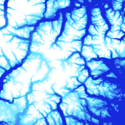
](/earth-engine/datasets/catalog/UMN_PGC_ArcticDEM_V4_2m_mosaic) |\n | ArcticDEM is a National Geospatial-Intelligence Agency (NGA) and National Science Foundation (NSF) public-private initiative to automatically produce a high-resolution, high-quality digital surface model (DSM) of the Arctic using optical stereo imagery, high-performance computing, and open source photogrammetry software. It includes vegetation, tree canopy, buildings, and ... |\n | [arctic](/earth-engine/datasets/tags/arctic) [dem](/earth-engine/datasets/tags/dem) [elevation-topography](/earth-engine/datasets/tags/elevation-topography) [geophysical](/earth-engine/datasets/tags/geophysical) [pgc](/earth-engine/datasets/tags/pgc) [umn](/earth-engine/datasets/tags/umn) |\n\n-\n\n |--------------------------------------------------------------------------------------------------------------------------------------------------------------------------------------------------------------------------------------------------------------------------------------------------------------------------------------------------------------------------------------------|\n | [### ArcticDEM Strips](/earth-engine/datasets/catalog/UMN_PGC_ArcticDEM_V3_2m) |\n | ArcticDEM is a National Geospatial-Intelligence Agency (NGA) and National Science Foundation (NSF) public-private initiative to automatically produce a high-resolution, high-quality digital surface model (DSM) of the Arctic using optical stereo imagery, high-performance computing, and open source photogrammetry software. It includes vegetation, tree canopy, buildings, and ... |\n | [arctic](/earth-engine/datasets/tags/arctic) [dem](/earth-engine/datasets/tags/dem) [elevation-topography](/earth-engine/datasets/tags/elevation-topography) [geophysical](/earth-engine/datasets/tags/geophysical) [pgc](/earth-engine/datasets/tags/pgc) [umn](/earth-engine/datasets/tags/umn) |\n\n-\n\n |---------------------------------------------------------------------------------------------------------------------------------------------------------------------------------------------------------------------------------------------------------------------------------------------------------------------------|\n | [### REMA Mosaic](/earth-engine/datasets/catalog/UMN_PGC_REMA_V1_1_8m) |\n | The Reference Elevation Model of Antarctica (REMA) is a high resolution, time-stamped Digital Surface Model (DSM) of Antarctica at 2-meter and 8-meter spatial resolutions. Mosaicked DEM files are compiled from multiple strips that have been co-registered, blended, and feathered to reduce edge-matching artifacts. |\n | [dem](/earth-engine/datasets/tags/dem) [elevation-topography](/earth-engine/datasets/tags/elevation-topography) [geophysical](/earth-engine/datasets/tags/geophysical) [pgc](/earth-engine/datasets/tags/pgc) [rema](/earth-engine/datasets/tags/rema) [umn](/earth-engine/datasets/tags/umn) |\n\n-\n\n |--------------------------------------------------------------------------------------------------------------------------------------------------------------------------------------------------------------------------------------------------------------------------------------------------------------------------|\n | [### REMA Strips 2m](/earth-engine/datasets/catalog/UMN_PGC_REMA_V1_2m) |\n | The Reference Elevation Model of Antarctica (REMA) is a high resolution, time-stamped Digital Surface Model (DSM) of Antarctica at 2-meter and 8-meter spatial resolutions. Strip DEM files correspond to the overlapping area of the input stereoscopic imagery pair strips as they are collected by DigitalGlobe's ... |\n | [dem](/earth-engine/datasets/tags/dem) [elevation-topography](/earth-engine/datasets/tags/elevation-topography) [geophysical](/earth-engine/datasets/tags/geophysical) [pgc](/earth-engine/datasets/tags/pgc) [rema](/earth-engine/datasets/tags/rema) [umn](/earth-engine/datasets/tags/umn) |\n\n-\n\n |--------------------------------------------------------------------------------------------------------------------------------------------------------------------------------------------------------------------------------------------------------------------------------------------------------------------------|\n | [### REMA Strips 8m](/earth-engine/datasets/catalog/UMN_PGC_REMA_V1_8m) |\n | The Reference Elevation Model of Antarctica (REMA) is a high resolution, time-stamped Digital Surface Model (DSM) of Antarctica at 2-meter and 8-meter spatial resolutions. Strip DEM files correspond to the overlapping area of the input stereoscopic imagery pair strips as they are collected by DigitalGlobe's ... |\n | [dem](/earth-engine/datasets/tags/dem) [elevation-topography](/earth-engine/datasets/tags/elevation-topography) [geophysical](/earth-engine/datasets/tags/geophysical) [pgc](/earth-engine/datasets/tags/pgc) [rema](/earth-engine/datasets/tags/rema) [umn](/earth-engine/datasets/tags/umn) |"]]