- در دسترس بودن مجموعه دادهها
- ۱۹۹۸-۰۸-۱۶T۰۰:۰۰:۰۰Z–۲۰۲۰-۰۵-۰۶T۰۰:۰۰:۰۰Z
- تولیدکننده مجموعه داده
- سازمان زمینشناسی ایالات متحده
- برچسبها
توضیحات
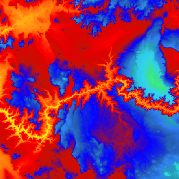
این مجموعه داده یکپارچه 3DEP DEM برای ایالات متحده با پوشش کامل ۴۸ ایالت هممرز، هاوایی و سرزمینهای ایالات متحده است. پوشش آلاسکا در حال حاضر تا حدی در دسترس است و به عنوان بخشی از طرح نقشهبرداری آلاسکا، به پوشش سراسری ایالت گسترش مییابد. فاصله زمینی تقریباً ۱۰ متر از شمال/جنوب است، اما به دلیل همگرایی نصفالنهارها با عرض جغرافیایی، از شرق/غرب متغیر است.
مجموعه داده ۱ میلیونی به صورت USGS_3DEP_1m دریافت میشود.
مجموعه دادهها توسط شبکه کسب و کار کشاورزان آپلود شده است.
باندها
باندها
اندازه پیکسل: ۱۰.۲ متر (همه باندها)
| نام | واحدها | اندازه پیکسل | توضیحات |
|---|---|---|---|
elevation | متر | ۱۰.۲ متر | ارتفاع |
شرایط استفاده
شرایط استفاده
بیشتر اطلاعات سازمان زمینشناسی ایالات متحده (USGS) در حوزه عمومی قرار دارد و میتوان بدون محدودیت از آنها استفاده کرد. اطلاعات بیشتر در مورد تأیید یا اعتباربخشی به USGS به عنوان منبع اطلاعات در دسترس است.
نقل قولها
سازمان زمینشناسی ایالات متحده، برنامه ارتفاع سهبعدی، مدل ارتفاعی دیجیتال با وضوح ۱۰ متر.
با موتور زمین کاوش کنید
ویرایشگر کد (جاوااسکریپت)
var dataset = ee.ImageCollection('USGS/3DEP/10m_collection')
var elevation = dataset.select('elevation');

Map.setCenter(-112.8598, 36.2841, 7);
Map.addLayer(elevation, {min: 0, max: 3000,   palette: [
    '3ae237', 'b5e22e', 'd6e21f', 'fff705', 'ffd611', 'ffb613', 'ff8b13',
    'ff6e08', 'ff500d', 'ff0000', 'de0101', 'c21301', '0602ff', '235cb1',
    '307ef3', '269db1', '30c8e2', '32d3ef', '3be285', '3ff38f', '86e26f'
  ],
}, 'elevation');