Page Summary
-
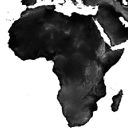
The USGS SRTMGL1_003 dataset provides digital elevation models globally at a 30m resolution from the Shuttle Radar Topography Mission (SRTM).
-
This version of the SRTM data includes void-filling using open-source data sources like ASTER GDEM2, GMTED2010, and NED.
-
The dataset is available from February 11 to February 22, 2000, and is provided by NASA / USGS / JPL-Caltech.
-
The primary band in this dataset is 'elevation', measured in meters, with a pixel size of 30 meters.
-
Images and video from JPL public websites used in conjunction with this data are generally available for any purpose without prior permission, with more information available on the JPL Image Use Policy site.
- Dataset Availability
- 2000-02-11T00:00:00Z–2000-02-22T00:00:00Z
- Dataset Producer
- NASA / USGS / JPL-Caltech
- Tags
Description
The Shuttle Radar Topography Mission (SRTM, see Farr et al. 2007) digital elevation data is an international research effort that obtained digital elevation models on a near-global scale. This SRTM V3 product (SRTM Plus) is provided by NASA JPL at a resolution of 1 arc-second (approximately 30m).
This dataset has undergone a void-filling process using open-source data (ASTER GDEM2, GMTED2010, and NED), as opposed to other versions that contain voids or have been void-filled with commercial sources. For more information on the different versions see the SRTM Quick Guide.
Documentation:
Bands
Bands
Pixel size: 30 meters (all bands)
| Name | Units | Min | Max | Pixel Size | Description |
|---|---|---|---|---|---|
elevation |
m | -10* | 6500* | 30 meters | Elevation |
Terms of Use
Terms of Use
Unless otherwise noted, images and video on JPL public web sites (public sites ending with a jpl.nasa.gov address) may be used for any purpose without prior permission. For more information and exceptions visit the JPL Image Use Policy site.
Citations
Farr, T.G., Rosen, P.A., Caro, E., Crippen, R., Duren, R., Hensley, S., Kobrick, M., Paller, M., Rodriguez, E., Roth, L., Seal, D., Shaffer, S., Shimada, J., Umland, J., Werner, M., Oskin, M., Burbank, D., and Alsdorf, D.E., 2007, The shuttle radar topography mission: Reviews of Geophysics, v. 45, no. 2, RG2004, at https://doi.org/10.1029/2005RG000183.
Explore with Earth Engine
Code Editor (JavaScript)
var dataset = ee.Image('USGS/SRTMGL1_003');
var elevation = dataset.select('elevation');
var slope = ee.Terrain.slope(elevation);
Map.setCenter(-112.8598, 36.2841, 10);
Map.addLayer(slope, {min: 0, max: 60}, 'slope');
import ee
import geemap.core as geemap
Colab (Python)
dataset = ee.Image('USGS/SRTMGL1_003')
elevation = dataset.select('elevation')
slope = ee.Terrain.slope(elevation)

m = geemap.Map()
m.set_center(-112.8598, 36.2841, 10)
m.add_layer(slope, {'min': 0, 'max': 60}, 'slope')
m