- ক্যাটালগের মালিক
- বন তথ্য অংশীদারিত্ব
- ডেটাসেট উপলব্ধতা
- 2020-01-01T00:00:00Z–2023-12-31T23:59:59Z
- ডেটাসেট প্রদানকারী
- বন ডেটা অংশীদারিত্বের জন্য Google দ্বারা উত্পাদিত৷
- ট্যাগ
- কোকো
বর্ণনা
দ্রষ্টব্য: এই ডেটাসেটটি এখনও পিয়ার-রিভিউ করা হয়নি। আরো তথ্যের জন্য এই GitHub README দেখুন.
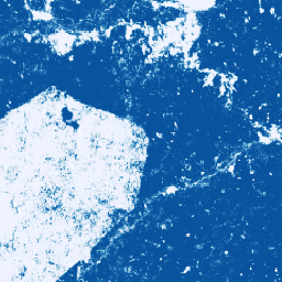
এই চিত্র সংগ্রহটি আনুমানিক প্রতি-পিক্সেল সম্ভাব্যতা প্রদান করে যে অন্তর্নিহিত এলাকাটি পণ্য দ্বারা দখল করা হয়েছে। সম্ভাব্যতা অনুমান 10 মিটার রেজোলিউশনে প্রদান করা হয়, এবং একটি মেশিন লার্নিং মডেল দ্বারা তৈরি করা হয়েছে। বিস্তারিত জানার জন্য, Github-এ ফরেস্ট ডেটা পার্টনারশিপ রেপোতে প্রযুক্তিগত ডকুমেন্টেশন দেখুন।
এই ইমেজ সংগ্রহের প্রাথমিক উদ্দেশ্য হল ফরেস্ট ডেটা পার্টনারশিপের মিশনকে সমর্থন করা যার লক্ষ্য বৈশ্বিক পর্যবেক্ষণ, সাপ্লাই চেইন ট্র্যাকিং এবং পুনরুদ্ধারের মাধ্যমে সহযোগিতামূলকভাবে পণ্য উৎপাদন থেকে বনের ক্ষতি বন্ধ করা এবং বিপরীত করা।
এই ডেটাসেটটি বর্তমানে নিম্নলিখিত দেশগুলিকে কভার করে: আইভরি কোট, ঘানা, ইন্দোনেশিয়া, ইকুয়েডর, পেরু, কলম্বিয়া৷
এই সম্প্রদায় ডেটা পণ্যটি সময়ের সাথে বিকশিত হওয়ার জন্য বোঝানো হয়েছে, কারণ সম্প্রদায় থেকে আরও ডেটা পাওয়া যায় এবং মানচিত্র তৈরি করতে ব্যবহৃত মডেলটি ক্রমাগত উন্নত হয়৷ আপনি যদি এই স্তরগুলিকে উন্নত করার জন্য সাধারণ প্রতিক্রিয়া বা অতিরিক্ত ডেটাসেট প্রদান করতে চান, অনুগ্রহ করে এই ফর্মটির মাধ্যমে যোগাযোগ করুন৷
সীমাবদ্ধতা: মডেল আউটপুট 2020 এবং 2023 সালের ক্যালেন্ডার বছরের কম্পোজিট হিসাবে নির্বাচিত দেশগুলিতে সীমাবদ্ধ। আউটপুটের সমস্ত অঞ্চল প্রশিক্ষণের ডেটা দ্বারা ভালভাবে উপস্থাপন করা হয় না। নির্ভুলতা সামগ্রিকভাবে রিপোর্ট করা হয়, এবং ভৌগলিকভাবে এবং ব্যবহারকারীর নির্বাচিত থ্রেশহোল্ডের সাথে পরিবর্তিত হবে। ডেটা প্রাপ্যতা, ক্রস-ট্র্যাক ননইফরমিটি বা ক্লাউডনেস এর উপর ভিত্তি করে সেন্সর আর্টিফ্যাক্টগুলি আউটপুট সম্ভাবনার মধ্যে দৃশ্যত স্পষ্ট হতে পারে এবং কিছু থ্রেশহোল্ডে শ্রেণীবিভাগ ত্রুটির কারণ হতে পারে।
মনে রাখবেন যে আর্থ ইঞ্জিনের বাণিজ্যিক ব্যবহারকারীদের জন্য এই ডেটাসেটের ব্যবহারের আলাদা শর্ত রয়েছে৷ বিস্তারিত জানার জন্য অনুগ্রহ করে "ব্যবহারের শর্তাবলী" ট্যাব দেখুন।
ব্যান্ড
পিক্সেল সাইজ
10 মিটার
ব্যান্ড
| নাম | মিন | সর্বোচ্চ | পিক্সেল সাইজ | বর্ণনা |
|---|---|---|---|---|
probability | 0 | 1 | মিটার | সম্ভাব্যতা যে পিক্সেল প্রদত্ত বছরের জন্য কোকো গাছ অন্তর্ভুক্ত করে। |
ব্যবহারের শর্তাবলী
ব্যবহারের শর্তাবলী
আর্থ ইঞ্জিনের অ-বাণিজ্যিক ব্যবহারকারীদের জন্য, ডেটাসেটের ব্যবহার CC-BY 4.0 NC লাইসেন্সের সাপেক্ষে এবং নিম্নলিখিত বৈশিষ্ট্যগুলির প্রয়োজন: "বন ডেটা পার্টনারশিপের জন্য Google দ্বারা উত্পাদিত"৷
ডেটাসেটের বাণিজ্যিক ব্যবহার ফরেস্ট ডেটা পার্টনারশিপ ডেটাসেট বাণিজ্যিক ব্যবহারের শর্তাবলীর সাপেক্ষে৷
পরিবর্তিত কোপার্নিকাস সেন্টিনেল ডেটা রয়েছে [2015-বর্তমান]। সেন্টিনেল ডেটা আইনি বিজ্ঞপ্তি দেখুন।
উদ্ধৃতি
বন তথ্য অংশীদারিত্ব. 2025. কমিউনিটি মডেল 2025a। অনলাইন
আর্থ ইঞ্জিন দিয়ে অন্বেষণ করুন
কোড এডিটর (জাভাস্ক্রিপ্ট)
Map.setCenter(-7.67, 6.71, 11);

var collection = ee.ImageCollection(
  'projects/forestdatapartnership/assets/cocoa/model_2025a');

var cocoa2020 = collection.filterDate('2020-01-01', '2020-12-31').mosaic();
Map.addLayer(
  cocoa2020.selfMask(), {min: 0.5, max: 1, palette: 'white,blue'}, 'cocoa 2020');

var cocoa2023 = collection.filterDate('2023-01-01', '2023-12-31').mosaic();
Map.addLayer(
  cocoa2023.selfMask(), {min: 0.5, max: 1, palette: 'white,green'}, 'cocoa 2023');