Оптимизируйте свои подборки
Сохраняйте и классифицируйте контент в соответствии со своими настройками.
информация
Этот набор данных входит в каталог Publisher и не управляется Google Earth Engine. Для сообщений об ошибках обращайтесь по адресу forestdatapartnership@googlegroups.com или просмотрите другие наборы данных из каталога Forest Data Partnership. Подробнее о наборах данных Publisher .
Примечание: этот набор данных ещё не прошёл рецензирование. Подробнее см. в файле README на GitHub .
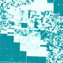
Эта коллекция изображений показывает оценку вероятности (попиксельно) того, что нижележащая область занята товаром. Оценки вероятности получены с разрешением 10 метров и получены с помощью модели машинного обучения. Подробнее см. техническую документацию в репозитории Forest Data Partnership на Github.
Основной целью этой коллекции изображений является поддержка миссии Партнерства по лесным данным , которая направлена на прекращение и обращение вспять процесса утраты лесов в результате товарного производства путем совместного совершенствования глобального мониторинга, отслеживания цепочек поставок и восстановления.
В настоящее время этот набор данных охватывает следующие страны: Индонезия, Малайзия, Таиланд, Нигерия, Колумбия, Бразилия, Кот-д'Ивуар, Гана, Эквадор и Гондурас.
Этот продукт, основанный на данных сообщества, будет развиваться со временем по мере поступления новых данных от сообщества и постоянного совершенствования модели, используемой для создания карт. Если вы хотите оставить отзыв или предоставить дополнительные наборы данных для улучшения этих слоёв, пожалуйста, свяжитесь с нами через эту форму .
Ограничения: Выходные данные модели ограничены выбранными странами в виде композитных данных за 2020 и 2023 календарные годы. Не все регионы, участвующие в расчетах, хорошо представлены в обучающих данных. Точность указывается в агрегированном виде и может варьироваться в зависимости от географического положения и пороговых значений, выбранных пользователем. Артефакты датчиков, связанные с доступностью данных, поперечной неравномерностью или облачностью, могут быть визуально заметны в выходных вероятностях и приводить к ошибкам классификации при некоторых пороговых значениях.
Обратите внимание, что для этого набора данных действуют отдельные условия использования для коммерческих пользователей Earth Engine. Подробнее см. на вкладке «Условия использования».
Группы
Размер пикселя 10 метров
Группы
Имя
Мин.
Макс
Размер пикселя
Описание
probability
0
1
метров
Вероятность того, что пиксель содержит пальмы для данного года.
Условия эксплуатации
Для некоммерческих пользователей Earth Engine использование набора данных регулируется лицензией CC-BY 4.0 NC и требует следующего указания источника: «Создано Google для Forest Data Partnership».
Примечание: Этот набор данных ещё не прошёл рецензирование. Подробнее см. в файле README на GitHub. Эта коллекция изображений показывает оценочную вероятность того, что нижележащая область занята товаром, с точностью до пикселя. Оценки вероятности получены с разрешением 10 метров и получены с помощью модели машинного обучения. Для…
projects/forestdatapartnership/assets/palm/model_2025a, сельское хозяйство, биоразнообразие, охрана природы, урожай, EUDR, forestdatapartnership, землепользование, пальма, плантация, набор данных издателя
[null,null,[],[],[],null,["# Palm Probability model 2025a\n\ninfo\n\n\nThis dataset is part of a Publisher Catalog, and not managed by Google Earth Engine.\n\nContact forestdatapartnership@googlegroups.com\n\nfor bugs or [view more datasets](https://developers.google.com/earth-engine/datasets/publisher/forestdatapartnership)\nfrom the Forest Data Partnership Catalog. [Learn more about Publisher datasets](/earth-engine/datasets/publisher). \n[](https://forestdatapartnership.org) \n\nCatalog Owner\n: Forest Data Partnership\n\nDataset Availability\n: 2020-01-01T00:00:00Z--2023-12-31T23:59:59Z\n\nDataset Provider\n:\n\n\n [Produced by Google for the Forest Data Partnership](https://www.forestdatapartnership.org/)\n\nTags\n:\n[agriculture](/earth-engine/datasets/tags/agriculture) [biodiversity](/earth-engine/datasets/tags/biodiversity) [conservation](/earth-engine/datasets/tags/conservation) [crop](/earth-engine/datasets/tags/crop) [eudr](/earth-engine/datasets/tags/eudr) [forestdatapartnership](/earth-engine/datasets/tags/forestdatapartnership) [landuse](/earth-engine/datasets/tags/landuse) [palm](/earth-engine/datasets/tags/palm) [plantation](/earth-engine/datasets/tags/plantation) [publisher-dataset](/earth-engine/datasets/tags/publisher-dataset) \n\n#### Description\n\n**Note: This dataset is not yet peer-reviewed. Please see this\n[GitHub README](https://github.com/google/forest-data-partnership/tree/main/models)\nfor more information.**\n\nThis image collection provides estimated per-pixel probability that the\nunderlying area is occupied by the commodity. The probability estimates are\nprovided at 10 meter resolution, and have been generated by a machine\nlearning model. For details, see the technical documentation on the\n[Forest Data Partnership repo](https://github.com/google/forest-data-partnership/tree/main)\non Github.\n\nThe primary purpose of this image collection is to support the mission of\nthe [Forest Data Partnership](https://www.forestdatapartnership.org/) which\naims to halt and reverse forest loss from commodity production by\ncollaboratively improving global monitoring, supply chain tracking, and\nrestoration.\n\nThis dataset currently covers the following countries: Indonesia, Malaysia,\nThailand, Nigeria, Colombia, Brazil, Côte d'Ivoire, Ghana, Ecuador, and\nHonduras.\n\nThis community data product is meant to evolve over time, as more data\nbecomes available from the community and the model used to produce the maps\ncontinuously improves. If you would like to provide general feedback or\nadditional datasets to improve these layers, please reach out through\n[this form](https://goo.gle/fdap-data).\n\nLimitations: Model output is limited to selected countries as calendar year\ncomposites for 2020 and 2023. Not all regions of the output are well\nrepresented by training data. Accuracy is reported in aggregate, and will\nvary geographically and with user chosen thresholds. Sensor artifacts based\non data availability, cross-track nonuniformity, or cloudiness may be\nvisually apparent in output probabilities and result in classification\nerrors at some thresholds.\n\n**Note that this dataset has separate terms of use for commercial users of\nEarth Engine. Please see \"Terms of Use\" tab for details.**\n\n### Bands\n\n\n**Pixel Size**\n\n10 meters\n\n**Bands**\n\n| Name | Min | Max | Pixel Size | Description |\n|---------------|-----|-----|------------|--------------------------------------------------------------------|\n| `probability` | 0 | 1 | meters | Probability that the pixel includes palm trees for the given year. |\n\n### Terms of Use\n\n**Terms of Use**\n\nFor non-commercial users of Earth Engine, use of the dataset is subject to\nCC-BY 4.0 NC license and requires the following attribution:\n\"Produced by Google for the Forest Data Partnership\".\n\nFor commercial use of the dataset you may request access using\n[this form](https://docs.google.com/forms/d/e/1FAIpQLSe7L3eh6t2JIPqEtAQwXwY7ZmW52v8W5vrIi4QN_XYgTNJZLw/viewform?resourcekey=0-db8WFCPwr2AZRhnrnH2SFg).\nAccess will be granted or denied on a case-by-case basis. Commercial use of\nthe dataset is subject to the [Forest Data Partnership Datasets Commercial\nTerms of Use](https://services.google.com/fh/files/misc/forest_data_partnership_datasets_commerical_terms_of_use.pdf).\n\nContains modified Copernicus Sentinel data \\[2015-present\\]. See the\n[Sentinel Data Legal Notice](https://sentinels.copernicus.eu/documents/247904/690755/Sentinel_Data_Legal_Notice).\n\n### Citations\n\nCitations:\n\n- Forest Data Partnership. 2025. Community models 2025a. [Online](https://github.com/google/forest-data-partnership/tree/main/models/README.md)\n\n### Explore with Earth Engine\n\n| **Important:** Earth Engine is a platform for petabyte-scale scientific analysis and visualization of geospatial datasets, both for public benefit and for business and government users. Earth Engine is free to use for research, education, and nonprofit use. To get started, please [register for Earth Engine access.](https://console.cloud.google.com/earth-engine)\n\n### Code Editor (JavaScript)\n\n```javascript\nMap.setCenter(110, 0, 11);\n\nvar collection = ee.ImageCollection(\n 'projects/forestdatapartnership/assets/palm/model_2025a');\n\nvar p2020 = collection.filterDate('2020-01-01', '2020-12-31').mosaic();\nMap.addLayer(\n p2020.selfMask(), {min: 0.5, max: 1, palette: 'white,blue'}, 'palm 2020');\n\nvar p2023 = collection.filterDate('2023-01-01', '2023-12-31').mosaic();\nMap.addLayer(\n p2023.selfMask(), {min: 0.5, max: 1, palette: 'white,green'}, 'palm 2023');\n```\n[Open in Code Editor](https://code.earthengine.google.com/?scriptPath=Examples:Datasets/forestdatapartnership/projects_forestdatapartnership_assets_palm_model_2025a) \n[Palm Probability model 2025a](/earth-engine/datasets/catalog/projects_forestdatapartnership_assets_palm_model_2025a) \nNote: This dataset is not yet peer-reviewed. Please see this GitHub README for more information. This image collection provides estimated per-pixel probability that the underlying area is occupied by the commodity. The probability estimates are provided at 10 meter resolution, and have been generated by a machine learning model. For ... \nprojects/forestdatapartnership/assets/palm/model_2025a, agriculture,biodiversity,conservation,crop,eudr,forestdatapartnership,landuse,palm,plantation,publisher-dataset \n2020-01-01T00:00:00Z/2023-12-31T23:59:59Z \n-90 -180 90 180 \nGoogle Earth Engine \nhttps://developers.google.com/earth-engine/datasets\n\n- [](https://doi.org/https://www.forestdatapartnership.org/)\n- [](https://doi.org/https://developers.google.com/earth-engine/datasets/catalog/projects_forestdatapartnership_assets_palm_model_2025a)"]]