-
USGS 3DEP 10m National Map Seamless (1/3 Arc-Second)
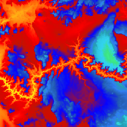
זהו מערך נתוני DEM של 3DEP בארה"ב, עם כיסוי מלא של 48 המדינות הרציפות, הוואי והטריטוריות של ארה"ב. הכיסוי באלסקה זמין באופן חלקי כבר עכשיו, והוא יורחב לכיסוי בכל רחבי המדינה כחלק מיוזמת המיפוי של אלסקה. הרווח בין השורות הוא… 3dep dem elevation elevation-topography geophysical topography -
USGS 3DEP 1m National Map

זהו אוסף של תמונות שמוצגות בצורה של משבצות, עם גודל פיקסל של מטר אחד, מתוך תוכנית 3D Elevation Program (3DEP). מאגר הנתונים של 3DEP משמש כשכבת הגובה של המפה הלאומית, ומספק מידע בסיסי על הגובה לצורך מחקרים במדעי כדור הארץ ויישומי מיפוי בארצות הברית. 3dep dem elevation elevation-topography geophysical topography -
נתוני מיקום (Spatial) של מפת USGS 3DEP National Map 1/3 Arc-Second (10m)

זוהי טבלה עם מטא-נתונים של נכס 3DEP 10m DEM. המטא-נתונים המרחביים של יחידת העבודה (WESM) מכילים את הזמינות הנוכחית של נתוני LiDAR ומידע בסיסי על פרויקטים של LiDAR, כולל רמת האיכות של LiDAR, תאריכי רכישת הנתונים וקישורים למטא-נתונים ברמת הפרויקט. פרטים נוספים… 3dep elevation-topography table usgs
Datasets tagged 3dep in Earth Engine
[null,null,[],[],["The USGS 3DEP dataset offers seamless DEM data for the US, including the 48 contiguous states, Hawaii, and US territories, with partial coverage of Alaska that is being expanded. This data is available at 10m and 1m resolution. The 10m DEM has corresponding metadata table for lidar data availability. This 3DEP information serves as the elevation layer for the National Map and supports earth science studies and mapping applications.\n"]]