وسعت سالانه جنگلهای حرا در جهان (۱۹۸۴-۲۰۲۳) 
مجموعه داده CGMD-Extent30 (دینامیک پیوسته جهانی حرا - وسعت سالانه حرا با وضوح 30 متر) وسعت سالانه جهانی حرا را از سال 1984 تا 2023 ارائه میدهد. این مجموعه داده به صورت یک مجموعه ویژگی موتور زمین واحد توزیع شده است که هر ویژگی نشان دهنده یک چندضلعی حرا نقشه برداری شده برای یک سال خاص است. مجموعه داده ... زیست توده سالانه جنگل ساحلی ، کاربری اراضی ، پوشش اراضی جهانی مشتق شده از لندست پوشش تاجی کسری سالانه جهانی حرا (1984-2023) 
این مجموعه دادهها، پوشش تاجی کسری (FCC) سالانه جهانی جنگلهای حرا را با وضوح مکانی 30 متر از سال 1984 تا 2023 ارائه میدهد تا از تجزیه و تحلیلهای گسترده در مورد پویایی بلندمدت جنگلهای حرا، از جمله تخریب و بازیابی تاج پوشش، ارزیابی کربن آبی و نظارت بر اکوسیستم ساحلی، پشتیبانی کند. FCC نسبت هر لندست ... را کمّی میکند. زیست توده سالانه جنگل ساحلی ، جنگل حرا جهانی مشتق شده از لندست توزیع جهانی جنگلهای حرا، جلد ۱ (۲۰۰۰) 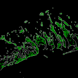
این پایگاه داده با استفاده از دادههای ماهواره لندست از سال ۲۰۰۰ تهیه شده است. بیش از ۱۰۰۰ صحنه لندست که از مرکز رصد و علوم منابع زمین (EROS) سازمان زمینشناسی ایالات متحده (USGS) به دست آمده است، با استفاده از تکنیکهای طبقهبندی تصاویر دیجیتال ترکیبی نظارتشده و نظارتنشده طبقهبندی شدهاند. این پایگاه داده اولین و پرکاربردترین ... تغییرات سالانه در زیست توده جنگلی، جنگل حرا مشتق شده از لندست جهانی تاریخچه طبقهبندی سالانه آب JRC، نسخه ۱.۴ 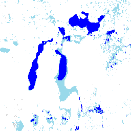
این مجموعه دادهها شامل نقشههایی از مکان و توزیع زمانی آبهای سطحی از سال ۱۹۸۴ تا ۲۰۲۱ است و آماری در مورد میزان و تغییر آن سطوح آب ارائه میدهد. برای اطلاعات بیشتر به مقاله مرتبط در مجله مراجعه کنید: نقشهبرداری با وضوح بالا از آبهای سطحی جهانی و ... تاریخچه سالانه ژئوفیزیک گوگل JRC مشتق شده از لندست MOD44B.061 پوشش گیاهی زمین، مزارع پیوسته، سالانه جهانی، ۲۵۰ میلیون 
محصول Terra MODIS Vegetation Continuous Fields (VCF) یک نمایش در سطح زیرپیکسل از برآوردهای پوشش گیاهی سطحی در سطح جهان است. این محصول که برای نمایش مداوم سطح زمین به عنوان نسبتی از ویژگیهای اساسی پوشش گیاهی طراحی شده است، درجهبندی سه جزء پوشش سطحی را ارائه میدهد: درصد پوشش درختی، درصد ... سالانه ژئوفیزیک جهانی استفاده از زمین-پوشش زمین مدیس ناسا ساختمانهای باز Temporal V1 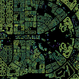
مجموعه دادههای زمانی ۲.۵ بعدی ساختمانهای باز شامل دادههایی در مورد وجود ساختمانها، تعداد کسری ساختمانها و ارتفاع ساختمانها با وضوح مکانی مؤثر ۴ متر (رسترها با وضوح ۰.۵ متر ارائه میشوند) در یک دوره سالانه از ۲۰۱۶ تا ۲۰۲۳ است. این مجموعه از تصاویر منبع باز و با وضوح پایین از ... تولید شده است. آفریقا، آسیا ، ارتفاع ساخته شده سالانه ، ساختمانهای باز جاسازی ماهواره نسخه ۱ 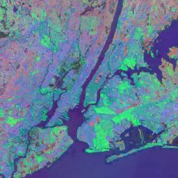
مجموعه دادههای Google Satellite Embedding مجموعهای جهانی و آماده برای تجزیه و تحلیل از جاسازیهای مکانی آموخته شده است. هر پیکسل 10 متری در این مجموعه داده، یک نمایش 64 بعدی یا "بردار جاسازی" است که مسیرهای زمانی شرایط سطح در آن پیکسل و اطراف آن را که توسط مشاهدات مختلف زمین اندازهگیری شده است، کدگذاری میکند... تصاویر ماهوارهای سالانه جهانی مشتق شده از گوگل لندست، مشتق شده از Sentinel1 کامپوزیتهای باند سالانه VIIRS Nighttime Day/Night نسخه ۲.۱ 
مجموعه دادههای سالانه جهانی VIIRS برای روشناییهای شبانه، یک سری زمانی است که از شبکههای میانگین درخشندگی ماهانه بدون ابر از سال ۲۰۱۳ تا ۲۰۲۱ تولید شده است. دادههای سال ۲۰۲۲ در مجموعه دادههای NOAA/VIIRS/DNB/ANNUAL_V22 موجود است. یک مرحله فیلتر اولیه، پیکسلهای روشن از نور خورشید، مهتاب و ابری را حذف کرد و منجر به ترکیبات تقریبی شد که... چراغهای سالانه dnb eog در شب noaa کامپوزیتهای باند سالانه VIIRS Nighttime Day/Night نسخه ۲.۲ 
مجموعه دادههای سالانه جهانی VIIRS مربوط به نورهای شبانه، یک سری زمانی است که از شبکههای میانگین تابش ماهانه بدون ابر برای سال ۲۰۲۲ تولید شده است. دادههای سالهای قبل در مجموعه دادههای NOAA/VIIRS/DNB/ANNUAL_V21 موجود است. یک مرحله فیلتر اولیه، پیکسلهای روشن از نور خورشید، مهتاب و ابری را حذف کرد و منجر به ترکیبات تقریبی شد که شامل ... چراغهای سالانه dnb eog در شب noaa
Datasets tagged annual in Earth Engine
[null,null,[],[],["The datasets provide annual global information on various Earth features. The Open Buildings dataset offers building presence, counts, and heights from 2016-2023. JRC data maps surface water distribution and changes from 1984-2021. Another dataset, based on data from 2000, details mangrove forest distribution. MODIS data provides continuous vegetation cover estimates, including tree cover percentages. Lastly, VIIRS data sets map annual nighttime light composites from 2013-2022, based on cloud-free average radiance grids.\n"]]