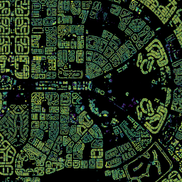
GHSL: ارتفاع ساختمان جهانی 2018 (P2023A) این مجموعه داده شطرنجی فضایی، توزیع جهانی ارتفاعات ساختمان را با وضوح 100 متر، به سال 2018 نشان می دهد. داده های ورودی مورد استفاده برای پیش بینی ارتفاع ساختمان، مدل سطح دیجیتال جهانی ALOS (30 متر)، ماموریت توپوگرافی رادار شاتل ناسا… آلوس ساختمان ساخته شده محیط داخلی ساخته شده کوپرنیک GHSL: مشخصات سکونتگاه جهانی (10 متر) 2018 (P2023A) این مجموعه داده شطرنجی فضایی سکونتگاههای انسانی را با وضوح 10 متر ترسیم میکند و ویژگیهای درونی آنها را از نظر اجزای عملکردی و مرتبط با ارتفاع محیط ساخته شده توصیف میکند. اطلاعات بیشتر در مورد محصولات داده GHSL را میتوانید در گزارش GHSL Data Package 2023 بیابید… ساختمان ساخته شده کوپرنیک ارتفاع ghsl Open Buildings Temporal V1 مجموعه دادههای زمانی 2.5 بعدی ساختمانهای باز حاوی دادههایی درباره حضور ساختمان، تعداد ساختمانهای کسری و ارتفاع ساختمان با وضوح مکانی موثر1 4 متر (راسترها با وضوح 0.5 متر ارائه میشوند) در یک آهنگ سالانه از 2016 تا 2023 است. این از تصاویر منبع باز و با وضوح پایین از… آفریقا سالانه آسیا ساخته شده تا ارتفاع ساختمان های باز
Datasets tagged height in Earth Engine
[null,null,[],[[["\u003cp\u003eThe Open Buildings 2.5D Temporal Dataset provides annual data (2016-2023) on building presence, counts, and heights across Africa and Asia at a 4m resolution.\u003c/p\u003e\n"],["\u003cp\u003eThe GHSL Global settlement characteristics dataset (2018) offers a 10m resolution view of human settlements, detailing their functional and height-related built environment features.\u003c/p\u003e\n"],["\u003cp\u003eThe GHSL Global building height dataset (2018) maps global building heights at a 100m resolution, leveraging data from ALOS and SRTM missions.\u003c/p\u003e\n"]]],["The Open Buildings Temporal Dataset offers annual data from 2016-2023 on building presence, counts, and heights at a 4m resolution, derived from low-resolution imagery. The GHSL dataset provides 10m resolution data on human settlements, detailing built environment characteristics and heights. Another GHSL dataset maps global building heights at 100m resolution for 2018, using data from sources like the ALOS Global Digital Surface Model.\n"],null,["# Datasets tagged height in Earth Engine\n\n-\n\n |-------------------------------------------------------------------------------------------------------------------------------------------------------------------------------------------------------------------------------------------------------------------------------------------------------------|\n | [### GHSL: Global building height 2018 (P2023A)](/earth-engine/datasets/catalog/JRC_GHSL_P2023A_GHS_BUILT_H) |\n | This spatial raster dataset depicts the global distribution of building heights at a resolution of 100 m, referred to the year 2018. The input data used to predict building heights are the ALOS Global Digital Surface Model (30 m), the NASA Shuttle Radar Topographic Mission ... |\n | [alos](/earth-engine/datasets/tags/alos) [building](/earth-engine/datasets/tags/building) [built](/earth-engine/datasets/tags/built) [built-environment](/earth-engine/datasets/tags/built-environment) [builtup](/earth-engine/datasets/tags/builtup) [copernicus](/earth-engine/datasets/tags/copernicus) |\n\n-\n\n |---------------------------------------------------------------------------------------------------------------------------------------------------------------------------------------------------------------------------------------------------------------------------------------------------------------|\n | [### GHSL: Global settlement characteristics (10 m) 2018 (P2023A)](/earth-engine/datasets/catalog/JRC_GHSL_P2023A_GHS_BUILT_C) |\n | This spatial raster dataset delineates human settlements at 10 m resolution, and describes their inner characteristics in terms of the functional and height-related components of the built environment. More information about the GHSL data products can be found in the GHSL Data Package 2023 report ... |\n | [building](/earth-engine/datasets/tags/building) [built](/earth-engine/datasets/tags/built) [builtup](/earth-engine/datasets/tags/builtup) [copernicus](/earth-engine/datasets/tags/copernicus) [ghsl](/earth-engine/datasets/tags/ghsl) [height](/earth-engine/datasets/tags/height) |\n\n-\n\n |--------------------------------------------------------------------------------------------------------------------------------------------------------------------------------------------------------------------------------------------------------------------------------------------------------------------------------|\n | [### Open Buildings Temporal V1](/earth-engine/datasets/catalog/GOOGLE_Research_open-buildings-temporal_v1) |\n | The Open Buildings 2.5D Temporal Dataset contains data about building presence, fractional building counts, and building heights at an effective1 spatial resolution of 4m (rasters are provided at 0.5m resolution) at an annual cadence from 2016-2023. It is produced from open-source, low-resolution imagery from the ... |\n | [africa](/earth-engine/datasets/tags/africa) [annual](/earth-engine/datasets/tags/annual) [asia](/earth-engine/datasets/tags/asia) [built-up](/earth-engine/datasets/tags/built-up) [height](/earth-engine/datasets/tags/height) [open-buildings](/earth-engine/datasets/tags/open-buildings) |"]]