-
Mosaico della Groenlandia del 2000 - Greenland Ice Mapping Project (GIMP)

Questo set di dati fornisce un mosaico di immagini completo con una risoluzione di 15 m della calotta glaciale della Groenlandia derivato da immagini Landsat 7 ETM+ e RADARSAT-1 SAR degli anni 1999-2002. I metodi includono una combinazione di mascheramento delle nuvole delle immagini, nitidezza panchromatic, campionamento e ridimensionamento delle immagini e così via. arctic gimp greenland imagery nasa polar -
Mosaico ArcticDEM V4.1
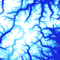
ArcticDEM è un'iniziativa pubblico-privata della National Geospatial-Intelligence Agency (NGA) e della National Science Foundation (NSF) per produrre automaticamente un modello digitale di superficie (DSM) di alta qualità e ad alta risoluzione dell'Artico utilizzando immagini stereo ottiche, calcolo ad alte prestazioni e software di fotogrammetria open source. Include vegetazione, chioma degli alberi, edifici e così via. arctic dem elevation-topography geophysical pgc umn -
Strisce ArcticDEM

ArcticDEM è un'iniziativa pubblico-privata della National Geospatial-Intelligence Agency (NGA) e della National Science Foundation (NSF) per produrre automaticamente un modello digitale di superficie (DSM) di alta qualità e ad alta risoluzione dell'Artico utilizzando immagini stereo ottiche, calcolo ad alte prestazioni e software di fotogrammetria open source. Include vegetazione, chioma degli alberi, edifici e così via. arctic dem elevation-topography geophysical pgc umn -
DEM della Groenlandia - Greenland Mapping Project (GIMP)

Questo modello digitale di elevazione (DEM) è costruito da una combinazione di DEM ASTER e SPOT-5 per la periferia e il margine della calotta glaciale (ovvero al di sotto dell'elevazione della linea di equilibrio) a sud di circa 82,5°N e fotoclinometria AVHRR all'interno della calotta glaciale e nell'estremo nord (Scambos e … arctic elevation-topography gimp greenland nasa polar -
Maschera di ghiaccio e oceano della Groenlandia - Greenland Mapping Project (GIMP)

Questo set di dati fornisce maschere di classificazione complete di ghiaccio terrestre e oceano a 15 m per la calotta glaciale della Groenlandia. La copertura di ghiaccio è stata mappata utilizzando una combinazione di immagini pancromatiche ortorettificate (banda 8) di Landsat 7 Enhanced Thematic Mapper Plus (ETM+), distribuite dall'USGS, e … arctic cryosphere gimp greenland ice nasa -
Velocità del ghiaccio della Groenlandia MEaSUREs: mappe di velocità dei siti dei ghiacciai selezionati da immagini ottiche versione 2

Questo set di dati, parte del programma NASA Making Earth System Data Records for Use in Research Environments (MEaSUREs), è costituito da mappe di velocità medie mensili per le aree di sbocco dei ghiacciai selezionate. Le mappe vengono generate monitorando le caratteristiche visibili tra le coppie di immagini ottiche acquisite da Landsat … arctic cryosphere gimp greenland ice nasa
Datasets tagged arctic in Earth Engine
[null,null,[],[],["The content details datasets from the Greenland Ice Mapping Project (GIMP) and ArcticDEM initiatives. GIMP provides a 15m resolution ice/ocean classification mask and a 2000 image mosaic of Greenland derived from Landsat 7 and RADARSAT-1. It also includes a digital elevation model (DEM) and mean monthly glacier velocity maps. ArcticDEM, a joint NGA/NSF project, offers high-resolution digital surface models (DSMs) of the Arctic, encompassing features like vegetation and buildings.\n"]]