-
BLM AIM TerrADat TerrestrialAIM Point v1
2011 年以降、米国土地管理局(BLM)は、Assessment Inventory and Monitoring(AIM)戦略を通じて、土地の健全性に関する情報を収集してきました。現在までに、BLM の土地で 6,000 を超える陸上 AIM フィールド プロットが収集されています。BLM AIM データ アーカイブは… blm ecosystems hydrology range soil table -
NLCD 2019: USGS National Land Cover Database、2019 年リリース
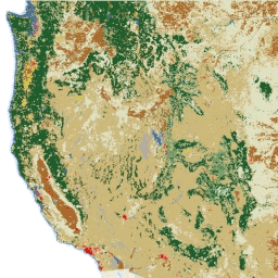
NLCD(National Land Cover Database)は、8 つのエポック(2001 年、2004 年、2006 年、2008 年、2011 年、2013 年、2016 年、2019 年)にわたる 30 m の Landsat ベースの土地被覆データベースです。2021 年の 9 番目のエポックもこちらで確認できます。この画像は、都市部の不浸透性データレイヤに依存しています。 blm landcover landuse-landcover mrlc nlcd usgs -
NLCD 2021: USGS National Land Cover Database、2021 年リリース
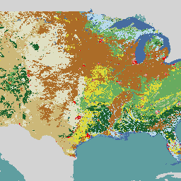
米国地質調査所(USGS)は、複数の連邦機関と提携して、7 つの National Land Cover Database(NLCD)プロダクト(NLCD 1992、2001、2006、2011、2016、2019、2021)を開発し、リリースしました。2016 年のリリース以降、土地被覆プロダクトは 2 ~ 3 年間隔で作成されました。 blm landcover landuse-landcover mrlc nlcd usgs
Datasets tagged blm in Earth Engine
[null,null,[],[],["The Bureau of Land Management (BLM) has collected over 6,000 terrestrial field plots since 2011 to assess land health through its AIM strategy. The USGS, in collaboration with federal agencies, has created the National Land Cover Database (NLCD), available for multiple epochs (2001-2021), updating land cover data. The NLCD utilizes 30-m Landsat-based imagery and is available from multiple years with two to three year intervals from 2016 onward.\n"]]