-
Lượng bốc hơi thực tế ở Úc (CMRSET Landsat phiên bản 2.2)

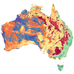
Tập dữ liệu này cung cấp thông tin chính xác về lượng bốc hơi thực tế (AET hoặc ETa) ở Úc bằng thuật toán CMRSET. Dải AET (được đặt tên là "ETa") chứa giá trị trung bình hằng ngày từ mô hình CMRSET cho tất cả các quan sát Landsat không có mây trong tháng đó (được biểu thị bằng giá trị 3 trong Dữ liệu AET … agriculture australia csiro evaporation evapotranspiration landsat-derived -
SLGA: Lưới đất và cảnh quan của Úc (Thuộc tính đất)
Lưới đất và cảnh quan của Úc (SLGA) là một tập dữ liệu toàn diện về các thuộc tính đất trên khắp nước Úc ở độ phân giải 3 giây cung (~90 mét mỗi pixel). Các bề mặt là kết quả của việc mô hình hoá mô tả sự phân bố không gian của các thuộc tính đất bằng cách sử dụng dữ liệu đất hiện có và dữ liệu môi trường … australia csiro soil tern
Datasets tagged csiro in Earth Engine
[null,null,[],[],[]]