طبقهبندی تغییرات جزر و مدی جهانی موری 
مجموعه دادههای تغییرات جزر و مدی جهانی موری شامل نقشههای جهانی از اکوسیستمهای پهنههای جزر و مدی است که از طریق طبقهبندی نظارتشده ۷۰۷۵۲۸ تصویر آرشیو لندست تولید شدهاند. هر پیکسل با ارجاع به مجموعهای از دادههای آموزشی توزیعشده در سطح جهان، به پهنههای جزر و مدی، آبهای دائمی یا موارد دیگر طبقهبندی شده است. ... تصاویر ماهوارهای موری از ساحل ، دادههای جزر و مدی گوگل ، دادههای سطحی-زمینی، آبهای زیرزمینی ماسک دادههای تغییرات جزر و مدی جهانی موری 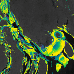
مجموعه دادههای تغییرات جزر و مدی جهانی موری شامل نقشههای جهانی از اکوسیستمهای پهنههای جزر و مدی است که از طریق طبقهبندی نظارتشده ۷۰۷۵۲۸ تصویر آرشیو لندست تولید شدهاند. هر پیکسل با ارجاع به مجموعهای از دادههای آموزشی توزیعشده در سطح جهان، به پهنههای جزر و مدی، آبهای دائمی یا موارد دیگر طبقهبندی شده است. ... تصاویر ماهوارهای موری از ساحل ، دادههای جزر و مدی گوگل ، دادههای سطحی-زمینی، آبهای زیرزمینی بررسی کیفیت تغییرات جزر و مدی جهانی موری، تعداد پیکسل 
مجموعه دادههای تغییرات جزر و مدی جهانی موری شامل نقشههای جهانی از اکوسیستمهای پهنههای جزر و مدی است که از طریق طبقهبندی نظارتشده ۷۰۷۵۲۸ تصویر آرشیو لندست تولید شدهاند. هر پیکسل با ارجاع به مجموعهای از دادههای آموزشی توزیعشده در سطح جهان، به پهنههای جزر و مدی، آبهای دائمی یا موارد دیگر طبقهبندی شده است. ... تصاویر ماهوارهای موری از ساحل ، دادههای جزر و مدی گوگل ، دادههای سطحی-زمینی، آبهای زیرزمینی تغییرات جهانی تالاب جزر و مدی موری نسخه ۱.۰ (۱۹۹۹-۲۰۱۹) 
مجموعه دادههای تغییرات تالاب جزر و مدی جهانی موری شامل نقشههایی از وسعت جهانی تالابهای جزر و مدی و تغییرات آنها است. این نقشهها از یک طبقهبندی سه مرحلهای تهیه شدهاند که به دنبال (۱) تخمین توزیع جهانی تالابهای جزر و مدی (که به صورت باتلاق جزر و مدی، جزر و مدی ... تعریف میشوند) است. اکوسیستم ساحلی، مانگرو مشتقشده از لندست، بین جزر و مدی ، مورای
Datasets tagged intertidal in Earth Engine
[null,null,[],[],["The content describes the Murray Global datasets, which map tidal wetland and intertidal flat ecosystems. The Tidal Wetland Change Dataset estimates the global distribution of tidal marshes and other tidal ecosystems. The Intertidal Change datasets classify pixels from 707,528 Landsat images into tidal flat, permanent water, or other categories. These datasets use a globally distributed training data to classify and map the global extent of intertidal areas and track changes.\n"]]