-
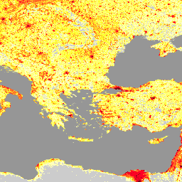
ウクライナの LandScan 高解像度データ(2022 年 1 月)
LandScan 高解像度(HD)は、3 秒角(約 100 m)の解像度でグリッド化された人口推定値を提供します。各 LandScan HD セルの値は、アンビエント(24 時間平均)の推定人口数を表します。このようにして、コース全体でユーザーの潜在的なアクティビティ空間を完全にキャプチャします。 landscan population -
LandScan 人口データ(世界 1 km)
Oak Ridge National Laboratory(ORNL)が提供する LandScan データセットは、包括的で高解像度のグローバルな人口分布データセットであり、幅広いアプリケーションに貴重なリソースとして活用できます。LandScan は、最先端の空間モデリング手法と高度な地理空間データソースを活用して、詳細な … community-dataset demography landscan population sat-io
Datasets tagged landscan in Earth Engine
[null,null,[],[[["\u003cp\u003eLandScan HD provides high-resolution (approximately 100m) gridded population estimates for Ukraine, reflecting the average daily population distribution.\u003c/p\u003e\n"],["\u003cp\u003eLandScan Global offers a 1km resolution global population distribution dataset using advanced spatial modeling and various data sources.\u003c/p\u003e\n"],["\u003cp\u003eBoth datasets are valuable resources for diverse applications requiring population data, with the former focusing on Ukraine and the latter providing a global perspective.\u003c/p\u003e\n"]]],["LandScan HD provides population estimates for Ukraine at a 3 arc-second (~100m) resolution, representing a 24-hour average population count per cell. LandScan Global, from Oak Ridge National Laboratory, offers a high-resolution global population distribution dataset. It utilizes spatial modeling and geospatial data to provide detailed population information for diverse applications. Both datasets are tagged with \"landscan\" and \"population,\" indicating their focus on population distribution analysis.\n"],null,["# Datasets tagged landscan in Earth Engine\n\n-\n\n |----------------------------------------------------------------------------------------------------------------------------------------------------------------------------------------------------------------------------------------------------------------------------------------------------------------------|\n | [### LandScan High Definition Data for Ukraine, January 2022](/earth-engine/datasets/catalog/DOE_ORNL_LandScan_HD_Ukraine_202201) |\n | LandScan High Definition (HD) provides gridded population estimates at 3 arc-second (\\~100m) resolution. Values for each LandScan HD cell represent an ambient (i.e. 24 hour average) population count estimate. In this way, the data capture the full potential activity space of people throughout the course ... |\n | [landscan](/earth-engine/datasets/tags/landscan) [population](/earth-engine/datasets/tags/population) |\n\n-\n\n |-----------------------------------------------------------------------------------------------------------------------------------------------------------------------------------------------------------------------------------------------------------------------------------------------------------------------------------------------------------------|\n | [### LandScan Population Data Global 1km](/earth-engine/datasets/catalog/projects_sat-io_open-datasets_ORNL_LANDSCAN_GLOBAL) |\n | The LandScan dataset, provided by the Oak Ridge National Laboratory (ORNL), offers a comprehensive and high-resolution global population distribution dataset that serves as a valuable resource for a wide range of applications. Leveraging state-of-the-art spatial modeling techniques and advanced geospatial data sources, LandScan provides detailed ... |\n | [community-dataset](/earth-engine/datasets/tags/community-dataset) [demography](/earth-engine/datasets/tags/demography) [landscan](/earth-engine/datasets/tags/landscan) [population](/earth-engine/datasets/tags/population) [sat-io](/earth-engine/datasets/tags/sat-io) |"]]