-
GLOBathy グローバル湖沼水深データセット
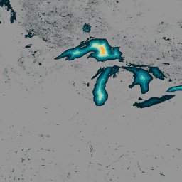
140 万を超える世界の水域に関するデータで構成される GLObal Bathymetric(GLOBathy)データセットは、広く認知されている HydroLAKES データセットと調和するように綿密に開発されています。GLOBathy は、高度な地理情報システム(GIS)ベースのフレームワークを使用して、最大深度の推定値と幾何学的/地球物理学的なデータを統合することで、詳細な水深図を作成します。 深浅測量 コミュニティ データセット hydrology sat-io surface-ground-water -
LandScan 人口データ グローバル 1 km
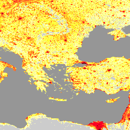
オークリッジ国立研究所(ORNL)が提供する LandScan データセットは、包括的で高解像度のグローバル人口分布データセットであり、幅広い用途で貴重なリソースとして活用できます。LandScan は、最先端の空間モデリング手法と高度な地理空間データソースを活用して、詳細なデータを提供します。 community-dataset demography landscan population sat-io -
米国干ばつモニター
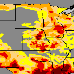
米国干ばつモニターは、毎週木曜日に公開される地図で、米国で干ばつが発生している地域を示しています。この地図では、干ばつが始まる可能性のある地域や干ばつから回復しつつある地域を示す異常乾燥(D0)と、4 つのレベルの干ばつという 5 つの分類を使用しています。 community-dataset drought noaa precipitation sat-io usda
Datasets tagged community-dataset in Earth Engine
[null,null,[],[],["The provided information describes three distinct datasets. GLOBathy offers bathymetric maps for over 1.4 million global waterbodies, harmonized with the HydroLAKES dataset, using GIS and depth estimates. LandScan, from ORNL, is a high-resolution global population distribution dataset developed through spatial modeling. The U.S. Drought Monitor is a weekly map classifying drought conditions across the U.S., utilizing five categories from abnormally dry to four drought levels. Each dataset is tagged as community dataset and sat-io.\n"]]