-
NLCD 2019: מסד הנתונים הלאומי של USGS בנושא כיסוי פני השטח, מהדורת 2019
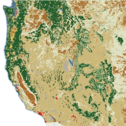
NLCD (מסד הנתונים הלאומי של כיסוי הקרקע) הוא מסד נתונים של כיסוי קרקע ברזולוציה של 30 מטר שמבוסס על נתוני Landsat, ומכיל נתונים מ-8 תקופות (2001, 2004, 2006, 2008, 2011, 2013, 2016 ו-2019). כאן זמין גם עידן תשיעי לשנת 2021. התמונות מבוססות על שכבת הנתונים של עמידות למים באזור העירוני… blm landcover landuse-landcover mrlc nlcd usgs -
NLCD 2021: מסד הנתונים הלאומי של USGS לגבי כיסוי פני השטח, מהדורת 2021
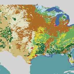
הסקר הגיאולוגי של ארה"ב (USGS), בשותפות עם כמה סוכנויות פדרליות, פיתח ועכשיו השיק שבעה מוצרים של מסד נתונים לאומי של כיסוי פני השטח (NLCD): NLCD 1992, 2001, 2006, 2011, 2016, 2019 ו-2021. החל מהמהדורה של 2016, מוצרים של כיסוי פני השטח נוצרו במרווחי זמן של שנתיים עד שלוש שנים… blm landcover landuse-landcover mrlc nlcd usgs
Datasets tagged mrlc in Earth Engine
[null,null,[],[],["The USGS National Land Cover Database (NLCD) provides 30-meter land cover data from Landsat imagery. It includes nine epochs: 2001, 2004, 2006, 2008, 2011, 2013, 2016, 2019, and 2021. NLCD products have been released for seven datasets : 1992, 2001, 2006, 2011, 2016, 2019 and 2021. The 2016 release started using two-to-three-year intervals. The data, which relies on imperviousness layers for urban areas, are created in partnership with federal agencies.\n"]]